Texas Railroad History - Tower 54 - Rockdale
A Crossing of the International & Great Northern Railroad and the San
Antonio & Aransas Pass Railway

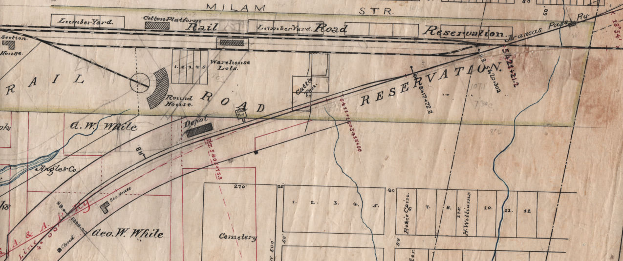
Above: Facing west, Tower 54 is shown in detail in this photograph
taken by railroad executive John W Barriger III from the rear platform of his
business car eastbound through Rockdale, probably in the mid to late 1930s. A switch into the International
- Great Northern Railroad yard is visible on the west side of the Plum St. grade
crossing. Barriger has just passed over the diamond of the former San Antonio &
Aransas Pass railroad, which had been acquired by Southern Pacific in 1925.
Rockdale was founded in 1873 as the International Railroad was building a rail line from Hearne to
Austin. By that time, the International had already
agreed to merge with the Houston & Great Northern (H&GN) Railroad to create the
International & Great Northern (I&GN) Railroad. The two railroads were
already led by a combined management team, but the merger required approval by
the Texas Legislature which was not yet forthcoming.
The H&GN had been chartered first, in 1866, by
Houston interests with a plan to build north to the
Red River. Construction was delayed for several years as major New York banks
were reluctant to lend money to a Texas railroad during the initial
Reconstruction period after the Civil War. Work finally began in Houston in
December, 1870, and by May, 1873, the tracks had reached
Palestine, 151 miles north. The H&GN's construction
team was the third such crew to reach Palestine
in less than a year! The other two belonged to the International, which had built
into Palestine from opposite directions. The International's goal was to
establish a route from Texarkana to the Mexican
border, hence the "International" name. Much of its financial backing came from
investors of the St. Louis, Iron Mountain & Southern (SLIM&S) Railway which was
building from St. Louis to Texarkana. The International had been chartered in August,
1870 to be essentially a Texas extension of the SLIM&S that would run through
Austin and San Antonio to Laredo.
The
International had commenced construction at both Hearne and Longview, in 1871.
In his reference tome A History of the Texas Railroads
(St. Clair Publishing, Houston, 1941), author S. G. Reed explains why.
Longview was selected instead of Texarkana as the Texas & Pacific [T&P]
was planning to build from Texarkana to Longview. Hearne was selected because
the H. & T. C. [Houston & Texas Central]
had reached that point. All the materials except ties, timber and piling, came
by steamer to Galveston and by barge or G. H. & H. [Galveston,
Houston & Henderson] to Houston, thence
to Hearne over the H. & T. C. By December 13, 1871, 50 miles had been completed
and by July 12, 1872, Palestine, 90 miles from Hearne, was reached. In the
meantime equally rapid progress was made on the line from Longview to Palestine,
which was completed January 31, 1873.
Before the H&GN had even reached Palestine, the
management of the International saw the value in a combined railroad that would
eventually serve Houston, Austin, San Antonio and Laredo, with favorable
connections to Galveston and Texarkana. In
December, 1872 (by which time only one of the three construction crews had
actually reached Palestine), the two railroads began operating under a combined
management structure headquartered in Houston while awaiting legal permission to
merge. With the lines into Palestine complete, the
International resumed construction, building south from Hearne toward Austin.
Land for the Rockdale townsite was acquired by the railroad in 1873,
reportedly including a large rock outcropping that inspired the town's name. A
sale of town lots was held on September 3rd, several months before the rails
reached Rockdale on January 28, 1874. Farming in the region had grown substantially
during the recovery from the Civil War, and the town quickly developed into a shipping point for local agriculture. In the 1890s,
lignite mines were dug in the vicinity, adding to the local economy.
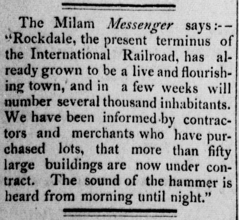 |
Left:
Quoting the Milam Messenger,
the Denison Daily News of
February 21, 1874 reported the rapid development at Rockdale. Since the Texas
Legislature had not yet granted a charter for their proposed I&GN
combination, the newspaper was correct that it was the International
Railroad that had reached the town. Getting a charter bill passed for
the I&GN required significant debate, drama and compromise in the
Legislature.
 There
was a major issue regarding the International's claim for construction
subsidy bonds to be issued by the state. Claiming corruption, the Texas
Comptroller had refused to countersign and register the bonds despite
the state engineer's report that the work covered by the bonds was of
high quality and met the requirements of the International's charter. As
legal proceedings moved slowly, a lengthy debate raged
statewide. Much ink was spilled as
to whether the bond issuance was in accordance with state law, or
instead constituted a demand by the International for an
unconstitutional subsidy. Legislators are usually responsive to
their constituents, and those constituents wanted railroads
now. This was certainly true in Austin,
which only had a line to Houston, and in San Antonio, which had no rail
lines at all. A compromise was ultimately found, and the charter
was issued. There
was a major issue regarding the International's claim for construction
subsidy bonds to be issued by the state. Claiming corruption, the Texas
Comptroller had refused to countersign and register the bonds despite
the state engineer's report that the work covered by the bonds was of
high quality and met the requirements of the International's charter. As
legal proceedings moved slowly, a lengthy debate raged
statewide. Much ink was spilled as
to whether the bond issuance was in accordance with state law, or
instead constituted a demand by the International for an
unconstitutional subsidy. Legislators are usually responsive to
their constituents, and those constituents wanted railroads
now. This was certainly true in Austin,
which only had a line to Houston, and in San Antonio, which had no rail
lines at all. A compromise was ultimately found, and the charter
was issued.
Left:
Galveston Daily News, March 26,
1875
After a year's delay, construction commenced out of
Rockdale on May 22, 1876, and the I&GN rails reached Austin seven months
later on December 16th. |
The second railroad through
Rockdale was the San Antonio & Aransas Pass (SA&AP) Railway. The SA&AP
had completed its initial main line between San Antonio and
Corpus
Christi in 1886, and then promptly began a plan for
additional construction. One of the new lines branched off the main at Kenedy and built as far as Wallis in 1887,
eventually to reach Houston. A branch from
the Wallis line was built north toward
Waco. It reached
West Point in late 1887 where work stopped
while a bridge was contemplated for the Colorado River two miles to the north.
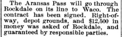
Right: The June 23, 1888 edition of
the San Antonio Daily Light
announced the route of the SA&AP through Rockdale.
The
Colorado River bridge was finished in 1889 and that year, the line was extended north to Lexington,
18 miles shy of Rockdale. A track segment from Waco south to
Lott, about 40 miles north of Rockdale, was also completed in 1889. The
SA&AP went into receivership in the summer of 1890, and the final 58-mile segment, from Lexington through Rockdale to Lott, was completed
during its bankruptcy in 1891, but not without difficulty. Track-laying
between Cameron and Lott was held up by a lawsuit filed by a contractor
for claims of unpaid grading work. After the suit was resolved and the
line completed, the
Brenham Weekly Banner
of October 29, 1891 simply reported "The gap between Cameron and Waco has been
closed." |
 |
 |
Tower 54 was authorized for operation by the Railroad
Commission of Texas (RCT) on September 1, 1904 to control the crossing of the
SA&AP and I&GN at Rockdale. It housed a 15-function mechanical interlocker built by
Union Switch & Signal Co. The fifteen functions implies additional control
beyond the minimum standard (12) for a basic crossing of two railroads, most
likely an exchange track. The function count decreased by one in 1916 and
remained at fourteen through the end of 1930 (after which, RCT no longer
published such data regularly.)
As the crossing had existed prior to
passage of Texas' interlocker law in 1901, the railroads were required to split
the capital cost of the tower and interlocker evenly. RCT documentation from 1916
states that the I&GN was responsible for the tower's operations and maintenance
(O&M) staffing, and this tends to imply that the I&GN had also taken the lead in building
the tower and acquiring the interlocking plant. The recurring O&M expenses
would have been
split between the two railroads on a "weighted function" basis, i.e. the
percentage of the interlocker's total functions assigned to each
railroad.
Barriger's Tower 54 photo
provides the
best available example of an I&GN tower. Though involved in numerous
towers, the I&GN took the construction lead on relatively few, and there is only one,
Tower 9 at Navasota, for which a photo has been
found.
Left:
This map shows only the I&GN and SA&AP rail lines, but there were
numerous others in the vicinity of Rockdale. Every town marked on this
map had an interlocker controlling the grade crossing of two railroads:
Tower 15 (Hearne),
Tower 23 (Milano), Tower 52 (Cameron),
Tower 132 (between Round Rock and Austin).
and Tower 205 (Austin.) Waco had four
interlockers: Tower 59
in downtown and Towers 8, 21 and 144 in
East Waco.
|
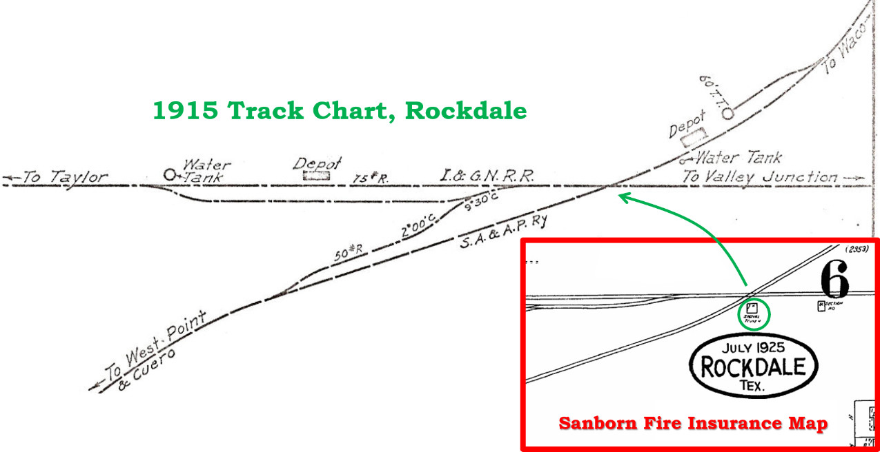
Above: This 1915 track chart
(courtesy Ed Chambers) from the Office of the Chief Engineer of the Missouri,
Kansas & Texas Railroad illustrates the crossing at Rockdale. Tower 54 is not
marked on the map, but an inset image from the July, 1925 Sanborn Fire Insurance
map of Rockdale has been added to show the location of Tower 54 (identified as
"Signal Tower" under magnification.) It also shows an I&GN "Section Ho" (house) east of the
tower. At least by 1915 and probably from the initial commissioning date for the
interlocker, there was an exchange track between the two railroads. Both
railroads developed small yards at Rockdale with multiple tracks. The I&GN's
yard was immediately west of Tower 54 (see Barriger's photo at top of page); the
SA&AP's yard was southwest of the tower.
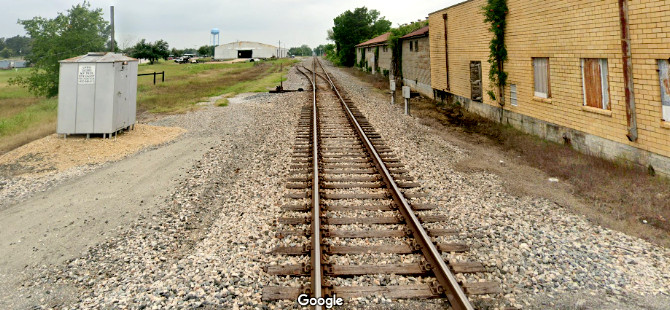
Below
Left: The tower foundation is visible on the south side of the
former I&GN tracks, now owned by Union Pacific. (Jim King photo c.2005)
Below Right: This Google
Street View taken in May, 2023 facing west from the Plum St. grade crossing
(literally atop the former location of the diamond)
approximates Barriger's view.

The I&GN proceeded to complete its line through San
Antonio to Laredo. It also added shared ownership of a rail line into
Galveston, and later built a main line from Houston
to Fort Worth. For many years, it was the largest railroad in
Texas. It was acquired by rail baron Jay Gould in 1880 but he briefly lost
control in the late 1880s. He reacquired the I&GN in 1891, and his son George
ran it for the next 25 years. Coming out of a lengthy receivership in 1922, the new
company formed to acquire the assets took on a slightly different name:
the International - Great Northern (I-GN) Railroad. The I-GN was acquired by
Missouri Pacific (MP) on January 1, 1925, but continued to operate under the
I-GN name until 1956. In 1982, MP was acquired by Union Pacific (UP), but continued to operate
separately until it was merged into UP in 1997. The I-GN line to Fort Worth is
mostly abandoned, but all of the other main line routes of the I-GN remain in
service under UP ownership.
The SA&AP
line became
a Southern Pacific (SP) property in 1925 and continued in operation for many
years. SP abandoned the line from Giddings
through Rockdale to Cameron in 1959, at which time Tower 54 was decommissioned.
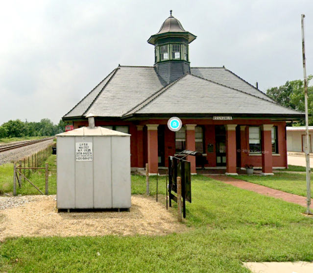
Above: The I&GN depot
still sits beside the tracks, now a museum.
(Google Street View) |

Above: The former
SA&AP depot has been repurposed for a business. (Google Street View) |
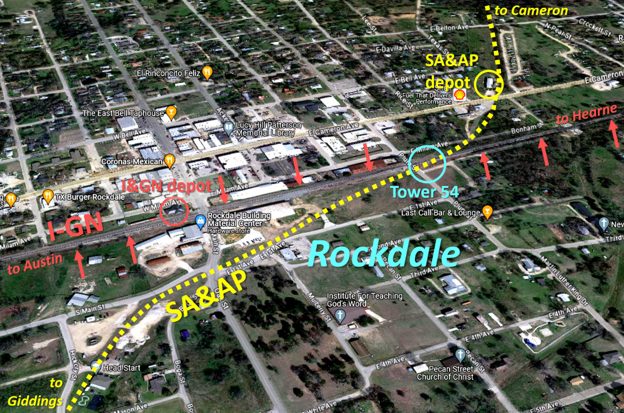
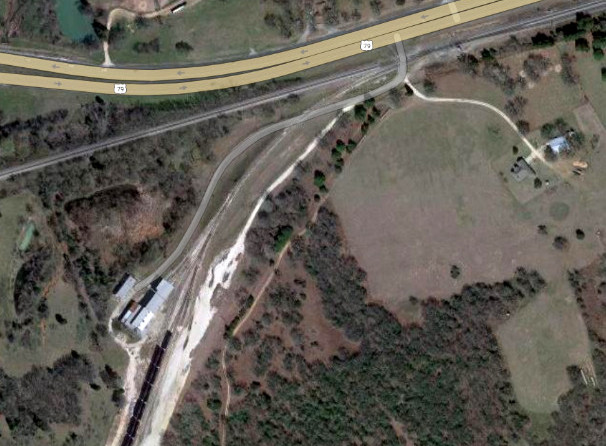
Above: This Google Earth satellite image of Rockdale
shows the SA&AP right-of-way curved to form an acute angle as it crossed the
I-GN at the Plum St. grade crossing. The former I-GN tracks (red arrows) remain heavily used as a major UP
route between the Midwest and Mexico. Below:
This image snippet from an undated rail map of Rockdale (Stuart Schroeder
collection) covers much of the same ground as the satellite image above. The map
does not show a structure at the SA&AP/I&GN crossing (upper right corner) so it
may have been drawn before the installation of Tower 54 in 1904. The crossing
shows a connection between the SA&AP main line and an I&GN siding, a connection
that does not appear on the 1915 track chart. Note the depot marked beside the
SA&AP tracks near the I&GN roundhouse. It apparently preceded the depot that
survives today in a different location (see above.) Under magnification, the
small square located trackside to the right of the depot says "Stock Pen".
"Cattle Pens" farther to the right appear to have been loaded from the I&GN
tracks. The pens overlap the SA&AP tracks but this does not seem likely, and it
is unknown whether there was a loading capability on the SA&AP side. Two
L-shaped section houses appear on the map, one for each railroad.
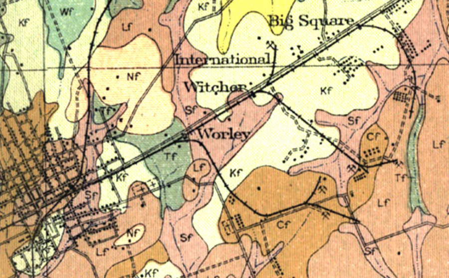
Above Left: Lignite was discovered
near Rockdale, and several mines opened, served by the I&GN. The
closest to Rockdale was a spur to
the Worley Coal Co. mine, only about a mile east of Tower 54. The Rockdale Lignite Co.
(Witcher mine), the International Coal Co. and the Big Square Coal Co.
all had spurs immediately east of the Worley spur, and the Big Lump Lignite Co.
had a spur about two miles farther east. (US Dept. of Agriculture 1913
Soil Map, courtesy Texas Transportation Archive)
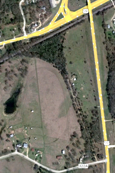
Above Right: The Worley spur, only a mile from the I&GN yard,
eventually incorporated a wye, perhaps for the convenience of the yardmaster;
the 1915 track chart does not show a wye in Rockdale but it does show a
turntable for the SA&AP. (Google Earth, March 2022)
When lignite was found west of Rockdale, the Federal
Fuel Co. opened a mine in 1919 and built a six-mile mine spur off the I&GN. In
1924, the mine's new owners chartered the spur as a common carrier railroad, the
Rockdale, Sandow & Southern
(RS&S), and applied to the Interstate Commerce Commission (ICC) for authority to
set interstate rates. This would allow the RS&S to negotiate divisions and
allowances with the I&GN which would result in receiving a percentage of the total revenue generated
from any interstate shipment from the mine, even though the length of RS&S' haul would always be the same.
This situation, where a railroad was owned by the company whose products it
shipped, had been litigated extensively in the Tap
Line Cases over the prior two decades. In Texas and the South, it was mostly
in regard to timber companies and sawmill trams failing to fulfill the
obligations of a common carrier. In the eastern U.S., it was railroads
owned by coal companies that had abused the railroad rate system with
unreasonable demands, leading to action by Congress.
The Hepburn Act of
1906 gave the ICC authority to set "just and reasonable" rates for railroad
transportation. It also outlawed railroads shipping products or commodities in
which they held a financial interest, although "...timber and the
manufactured products thereof..." were exempted from this provision. The
ICC had initiated litigation against numerous southern railroads owned by timber
companies, and many such tap lines were found to be non-compliant with
various obligations of common carrier status [Common carriers
had two significant legal obligations: they were required to offer
transportation services to the public without discrimination, and they had to
set public tariffs and charge fees for all of their services, i.e. mills that
owned railroads still had to pay them for the transportation services they
performed.] As long as common carrier obligations were met, the hauling
of logs and wood products to and from a mill that owned the railroad was legal
by the Hepburn Act, and the ICC's efforts to claim otherwise failed to gain
traction in court. As Ernest M. Teagarden described it in
The History of Federal Regulation of Railroad Joint
Rate Divisions (Bowling Green State University, Ohio, June, 1955) "In
the final analysis, about all the Commission had accomplished toward a solution
of the tap line problem was to have its power defined by the Supreme Court.
Commission policy had been shifted from a policy of preventing proprietary
divisions to one of regulating them." The ICC ultimately refused to grant
the RS&S the interstate rate-setting permission it sought. The RS&S continued to
serve the mine, but without the benefit of divisions and allowances
negotiated with the I&GN for interstate shipments (not that there were any;
lignite is a low energy fuel, hence larger volumes are required, limiting its
viability to short hauls.) Lignite was eventually overtaken by more efficient
fuels, and the RS&S carried its last load of lignite in 1950.
That was
not, however, the end of the RS&S. In 1952, Aluminum Co. of America (Alcoa) built
a smelter near the mine, excavating and burning the lignite on site to generate
the large amount of electricity needed for the plant. Aloca upgraded the RS&S to support shipping aluminum ores and products to and
from various Aloca sites. The nature of the shipping requirements and other
factors allowed the ICC to
grant interstate rate authority to the RS&S. The Rockdale smelter reportedly
became the largest aluminum smelter in the world, but eventually the pollution
that resulted from the burning of lignite caused the plant to fall out of
compliance with the Clean Air Act. Aloca shut down the smelter in
2008 and sold all of the property to a real estate investment company in 2021.
Plans to develop 3,300 acres of the property into an industrial site with 50
million square feet of space were announced in July, 2023. The former RS&S tracks
remain intact, presently out of service.
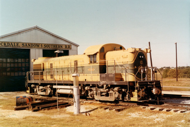
Below Left: The RS&S switch
off the I&GN is located about six miles west of the Tower 54 crossing. A small
engine house and maintenance yard is located near the switch.
Below Right: An Alco RS-3,
RS&S #10, sits outside the engine house in October, 1970. (Murry Hammond
collection, Texas Transportation Archive)