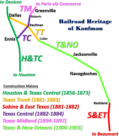
Texas Railroad History - Tower 39 - Kaufman
A Crossing of the Texas & New Orleans Railway and the Texas
Midland Railroad
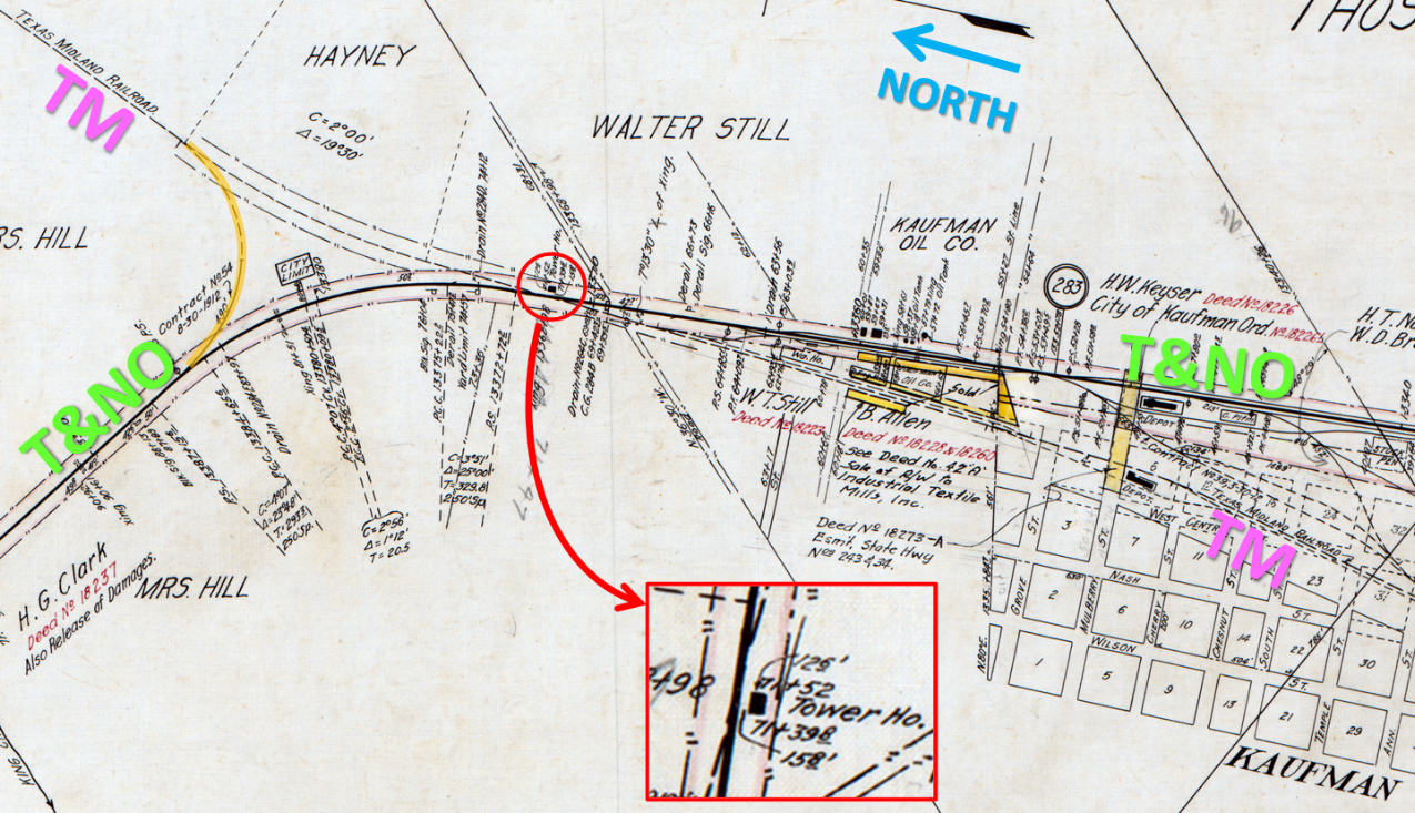
Above: This map produced by the Texas & New Orleans
(T&NO) Railroad shows the details of its right-of-way ownership and easements
through the town of Kaufman. The map was drawn with North generally to the left;
the T&NO right-of-way through town ran nearly due north/south. In the early
1900s, maps of this nature were maintained by draftsmen who added and erased
features as changes occurred. Neither the map's creation date nor its date of
last modification are known. The connecting track (orange) between the T&NO and
the Texas Midland (TM) Railroad is annotated with "Contract No. 54, 8-30-1912",
the most recent date that appears on the map. Significantly, the map shows Tower 39,
identified as "Tower Ho." (house) measuring 15 ft. 8 in. by 12 ft. 6 in.,
at a trackside location directly east of the TM / T&NO diamond (red inset,
rotated with North up.) This is the only
source found thus far that shows the size and location of the tower. (map
courtesy Temple Railroad and Heritage Museum collection)
The town of Kaufman was originally known as Kingsboro
when the settlement was founded in the 1840s. In 1848, Kaufman County was organized by
the State of Texas and the town was renamed for the county which had been named
for David Kaufman, a political leader of the Republic of Texas. Kaufman got its
first rail service in August, 1881 when the Texas Trunk (TT) Railroad
arrived from Dallas, 36 miles away. The Trunk had been chartered two years earlier
to build from Dallas to Sabine Pass on the Gulf of Mexico, but after reaching
Kaufman, it went into receivership. Briefly out of receivership, the tracks were
extended sixteen miles southeast to Cedar in 1883. In and out of receivership
two more times with no further construction, the fate of the Trunk was not
resolved until 1898 when it was purchased by the Texas & New
Orleans (T&NO) Railway, a subsidiary of Southern Pacific (SP). Even then,
the fate of the Trunk was not finally resolved because the acquisition still
needed to be approved by the Texas Legislature.
 |
Left:
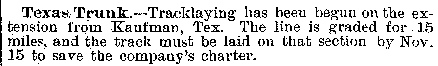
This item in The Railroad Gazette
of November 2, 1883 suggests that the Texas Trunk extension to Cedar was
necessary "...to save the company's charter." In A History of the
Texas Railroads (1941, St. Clair Publishing), author S. G.
Reed described Cedar as an agricultural area, but makes no mention of a
charter issue. |
The railroad that became the T&NO had been chartered by a
lumber company seeking to connect southeast Texas sawmills to
Galveston. Shortly before the Civil War, the T&NO
name was adopted when the vision for the railroad expanded toward building a
Houston - New Orleans rail line. The War
substantially damaged the T&NO, but it was rehabilitated and it operated a
train between Houston and
Orange in November, 1876. Scheduled service between
Houston and New Orleans with stops in Beaumont and Orange commenced in 1880,
making it very attractive to SP, which wanted to assemble a southern
transcontinental rail line between California and New Orleans. SP proceeded to acquire the T&NO
in 1881. To capitalize on lumber mills opening in the forests of east Texas north of Beaumont,
SP
acquired the Sabine & East Texas (S&ET) Railway and assigned it
to the T&NO. The SE&T had laid tracks
from Sabine Pass on the Gulf of Mexico through Beaumont to Rockland.
Despite the availability of capital resulting from SP's ownership, the SE&T
conducted no further construction north of Rockland.
|
To approve T&NO's 1898 acquisition of the Texas Trunk,
the
state law passed in 1899 mandated
that T&NO complete a continuous line between Dallas and Beaumont by
closing the gap from Cedar to Rockland. Rockland's location is
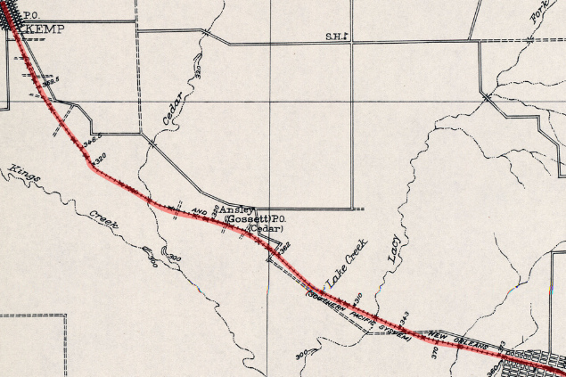
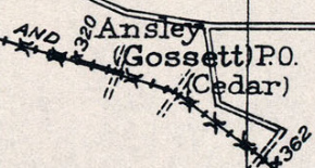
well-known, but where was Cedar? It is known to have been the endpoint of 15.7 miles of track laid by the Texas Trunk in 1883, placing it in southern Kaufman County
between Kemp and Mabank. In A History of the
Texas Railroads, S. G. Reed described Cedar as an agricultural area. "...The principal
farmer around there was M. H. Gossett, who later became a prominent
lawyer... The station of Cedar was later changed to Gossett in his
honor."
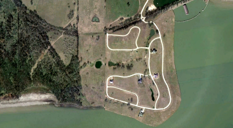
Left: This snippet of a 1919
Army Corps of Engineers topographic map (courtesy University of Texas
Perry-Castaneda Library) shows the location of Cedar along the T&NO
rail line (red highlight) between Kemp and Mabank. The magnified
map (below left) shows
that by 1919, Gossett had been renamed Ansley, and that it had a Post
Office. Today, the former site of Cedar (below
right) is a residential area on a peninsula into Cedar
Creek Reservoir.
 |
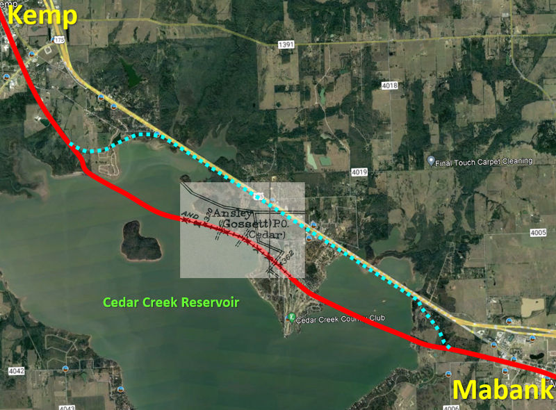 |
Left:
Adding the above map and graphics to Google Maps satellite imagery yields a
pictorial representation of where Cedar was located in today's context.
The 1961 construction of Cedar Creek Reservoir caused the T&NO to
relocate its tracks (light blue) to the U.S. Highway 175 right-of-way
between Mabank and the southeast outskirts of Kemp.
Above: Near the
lakeshore southeast of Kemp, the new T&NO right-of-way turned abruptly
to the northeast to reach the Hwy 175 alignment.
Below: The east connection
was on the west outskirts of Mabank.
 |
The law authorizing T&NO's
acquisition of the Texas Trunk mandated several requirements. One unusual
provision was that the tracks through Henderson County
were to use a right-of-way
at least 100 ft. wide to be donated by the county, with the title conveyed to
the T&NO. The depot grounds at
Athens, the county seat, were to be provided by the town and also conveyed by title to the
T&NO. Why was Henderson County alone singled out for the requirement to
provide a right-of-way and depot grounds when there were many other counties
through which the line would pass? Was this a means of forcing T&NO to build
through Athens? (A more direct path would have routed farther south through
Palestine and Lufkin.) The answer may lay in the Sabine Pass & Northwestern
Railroad. It had been chartered in the summer of 1877 by investors from Kaufman
and Lawrence, a tiny community between Terrell and
Forney ten miles north of Kaufman. S. G. Reed notes that the Sabine Pass &
Northwestern appeared in the gold standard of railroad business
publications, Poor's Manual, but that
Poor's Manual...
...apparently ... was misinformed
about this enterprise. In its issue for 1879, it reports that 11 miles from
Lawrence, Texas to Kaufman was completed, already graded from Lawrence to
Athens, 50 miles... that the whole road was under contract from Sabine Pass to
Denison... However, in subsequent issues no mention is made of this road... The
author has sought information from old timers in the sections where this road is
supposed to have been graded and in operation. From these sources it is learned
that a few miles of grade was thrown up out of Lawrence toward Kaufman but no
rails were laid, and the project was abandoned about 1880.
A Denison Daily News
article from October 22, 1878 asserts that the Sabine Pass & Northwestern had "...fifty-one
miles, connecting Lawrence and Athens, graded, bridged and ties placed ready for
the iron..." Whatever the real truth, it seems likely that at least
some level of survey work and easement development had been performed in
Henderson County between Cedar and Athens. If the grade actually existed, it's
possible that the Texas Trunk followed it building from Kaufman to Cedar.
Assuming the Legislature was aware of a survey (and perhaps a grade) into
Athens, they might have wanted to simplify the T&NO's acquisition of a right-of-way
through Henderson County by forcing the county to condemn the path that had
already been identified. And there's no doubt that Henderson County's
legislators would have wanted to force the T&NO to build through Athens, even if
it required condemning land.
Beyond the Henderson County requirements, the
1899 law further mandated a minimum of fifty miles of track to be laid by T&NO in each of the first two
years after the passage of the law. T&NO accepted its obligations and
began construction
at Cedar, reaching Athens (26 miles) in 1900, Frankston (22 miles) in 1901, and
Jacksonville (15 miles) in 1902. On the south end,
T&NO started at Rockland and laid 57 miles of track by 1902, reaching a location
six miles beyond Nacogdoches. From there, T&NO built the final 38 miles to
Jacksonville in 1903. Several towns with SP-inspired names were founded during construction, e.g.
Cushing, named for SP Assistant General Manager Edward Cushing, and Poyner,
named for D. A. Poyner, a T&NO surveyor.
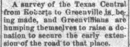
The Texas Trunk had been the first railroad to reach Kaufman, but it arrived only a year
ahead of the Texas Central (TC) Railroad. The TC passed through
Kaufman as it built the initial 38 miles of its "northeast branch" from Garrett to
Terrell, with work trains operating into Terrell by August, 1882 (according to
the Brenham Daily Banner of August 19, 1882.) Garrett was a junction a few miles north of Ennis on
the main line of the Houston & Texas Central (H&TC) Railroad which ran between
Houston
and Denison. The TC had been chartered in 1879 by
H&TC's owners/investors as they sought to isolate the financial impact of building two major branch lines
for the H&TC. The other was the TC's "northwest branch", which actually began at
Bremond on the H&TC main line but the first 55 miles through
Waco to Ross were owned by an H&TC subsidiary, the Waco & Northwestern (W&NW). Ostensibly heading for the Texas Panhandle, the TC
had extended the northwest branch 178 miles from Ross to Albany in 1879-1881,
crossing the Brazos River, a major undertaking, near
Morgan. No further construction was done on the northwest
branch, but by early 1883, the northeast branch had been
extended fourteen miles north from Terrell to Roberts (with work trains
operating into Roberts by November 11, 1882 as reported by the
Galveston Daily News.) Roberts was established
by the railroad on land acquired in October, 1882 from then Governor Oran M.
Roberts. It was nineteen
miles south of Greenville, and it later faded away
when the nearby town of Quinlan was established.
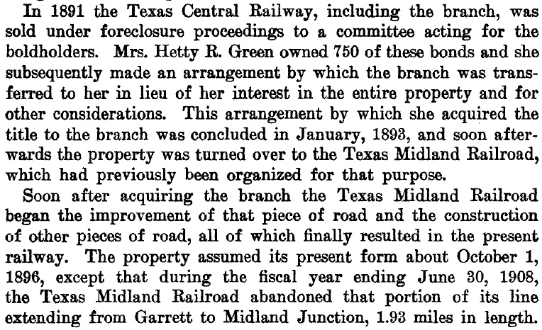 |
Left: This succinct
history of the founding of the Texas Midland Railroad is taken from a
Valuation Report
generated by the Interstate Commerce Commission (ICC) staff on June 30,
1914 and ratified by the ICC on July 31, 1918. The delay resulted from
numerous challenges to the methodology used in computing the railroad's value.
The
Depression of 1882-1885 hit railroads particularly hard, resulting
in the H&TC entering receivership in February, 1885. This was
followed quickly by receivership for the TC on April 4, 1885. Both
railroads stayed in bankruptcy proceedings for several years and there
was
substantial overlap among their bondholders. In April, 1890, the H&TC
was reorganized and sold to SP, but the W&NW branch
(Bremond to Ross) was not part of the sale. A year later, the TC was sold to a committee of bondholders who chartered a new TC to
operate the northwest branch. Wealthy Wall St. investor Hetty
Green, a major bondholder of both TC and H&TC bonds, negotiated to
relinquish her substantial interest in the northwest
branch in exchange for title to the northeast branch consisting of 52 miles of track
from Garrett to Roberts. She sent her son, Edward H. R. "Ned" Green, to
manage her interests and he chartered the Texas Midland (TM) Railroad to operate and
extend the northeast branch. When the W&NW was put up for auction by
the bankruptcy judge, Ned
Green won it with a high bid of $1.365 million, planning to consolidate
the TM and the W&NW into a new Texas railroad. Unfortunately for
Green, the terms of the sale were
challenged successfully in court and the auction was set aside. After a
lengthy court battle, Green gave up and did not participate in the
subsequent W&NW auction, which was won by SP.
|
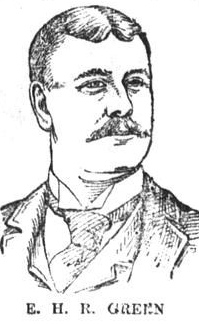 |
Left: A profile of E. H. R. Green in the
El Paso International Daily Times
of May 30, 1891 (nearly a year before Green arrived in Texas) described him as a savvy businessman who had already
amassed a personal net worth of $10 million despite being only 24 years
old. Green ran his railroad from Terrell, and became notorious for
bringing the first automobile to Texas, which he drove to Dallas
periodically to visit his girlfriend (she could not live in Terrell due
to her unsavory past.) Green carried his large frame (6'4", ~ 275 lbs.)
on an artificial leg resulting from an amputation in 1887. Although
Green was awarded the honorary title of Colonel by his friend Texas
Governor Oscar Colquitt after the 1910 election, an article in the
Forney Tribune
of September 21, 1892 shows that, nearly twenty years earlier, he was
already being addressed as Col. Green. Perhaps the Governor wanted to
make it official...
Green's
most significant undertaking may have been due to his concern that
Texas' cotton crop was doomed unless the boll weevil could be
eradicated. Hauling cotton was the lifeblood of his railroad, so Green financially supported experimental cotton farms near
Terrell to test cotton hybrids and new methods of cultivation.
This ultimately led to success in the fight against the boll weevil and
became the impetus for the establishment of the
County Extension Service
across Texas managed through Texas A&M University. |
Above: Although title
to the TC's northeast branch was not finalized until 1893, Hetty Green
wasted no time once the 1891 agreement with its bondholders had been
consummated. E. H. R. Green arrived in Texas in 1892, and he was soon funding the efforts to extend the northeast branch to
Greenville. The first train reached Greenville on August 25, 1894. (Forney Tribune,
February 24, 1892) |
Under Green's leadership, the TM
immediately established a new connection with the H&TC at Ennis. This
involved building a 4-mile track south to Ennis that departed the TM's
existing line two miles east of Garrett. (The leftover two miles of main
line into Garrett was abandoned in 1907.) Green followed
up by building nineteen miles of track from Roberts to Greenville (a
town for which Green had an obvious affinity.)
Greenville was already served by the St. Louis Southwestern ("Cotton
Belt") and Missouri, Kansas & Texas ("Katy") railroads,
which would be potential interchange partners for traffic destined to
Houston / Galveston via Ennis, bypassing congestion in Dallas.
Green was only 27 years old and he began relying on the advice of B. F.
Yoakum, a 36-year old rising star among Texas railroad executives who
was in the process of becoming the General Manager of the St. Louis - San Francisco ("Frisco")
Railway, a major Midwest railroad. Yoakum advised Green to build to
Paris, so Green procured rights to use the
Cotton Belt tracks between Greenville and Commerce. From Commerce, Green built 37 miles
north to Paris, arriving in 1896. Yoakum's advice proved both prescient
and self-serving; the TM's tracks provided an efficient connection
between the Frisco at Paris and the H&TC at Ennis for traffic to south
Texas. Soon, the Frisco, the H&TC and the TM combined to run first class
Lone Star Limited passenger service between St. Louis and Houston, with the Ennis - Paris
segment operated by the TM.
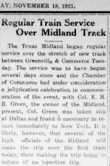
Right:
In November, 1921, the TM dropped its rights on the Cotton Belt and
began operating on its own 14-mile line between Greenville and Commerce.
The impetus for building this track segment is undetermined, but Green
had been pondering it for many years. TM accounting records report a
preliminary survey (valued at $444.25!) had been completed prior to
1914. The new line was no shorter since it paralleled the Cotton Belt
for the entire distance, thus the cost of trackage rights and/or
congestion delays was presumably the principal motivation. Parallel
lines of this nature were generally frowned upon by RCT, but this
segment was encompassed within the route approved in TM's charter, hence
no additional authority was needed. This newspaper article goes on to
list a new "time card" for the four daily trains through Cooper (located
between Commerce and Paris) but does not state whether the schedule
change was a direct result of the new track segment. (Cooper
Review, November 18, 1921)
Starting around 1910, Ned Green began
spending much of his time in New York helping his mother with her complex
business affairs and assisting in managing her estate. She was 76 years old at
the time, and she died in 1916 at age 81. Ned Green inherited half of his
mother's estate (the other half went to his sister), and he was finally able to
marry his longtime girlfriend who was still living in Dallas (his mother opposed
the marriage, hence Green waited, lest he jeopardize his massive inheritance.)
Green continued to own and operate the Texas Midland until 1928 when he sold it
to SP, which merged it into the T&NO. |
 |
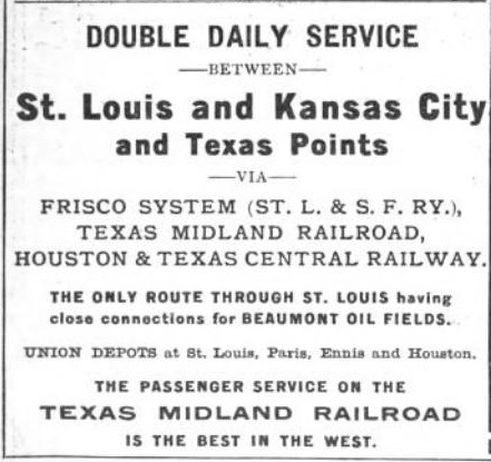
Above: This Texas Midland ad for St. Louis - Galveston passenger service is from the 1902
Official Railway Guide. Note the
reference to "Beaumont Oil Fields" in the ad; the Spindletop Oil Field
had been
discovered at Beaumont in January, 1901, producing 17.5 million barrels
of oil in 1902.
Left:
railroad heritage of Kaufman
Right:
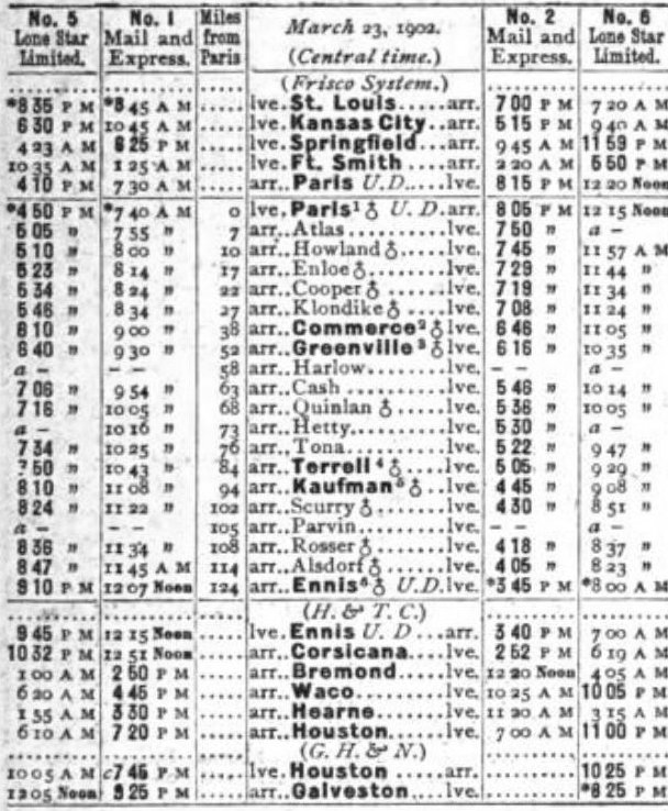
TM's St. Louis - Galveston passenger service schedule from the 1902
Official Railway Guide. Waco was on the
W&NW branch from Bremond, not the H&TC main line, but it was large
enough to justify showing the connection.
|
Right:
These disconnected excerpts are taken from a lengthy article about the
Texas Midland in the June 1, 1895 issue of the
Greenville Banner. Green had
been on the job only a couple of years and had little practical knowhow
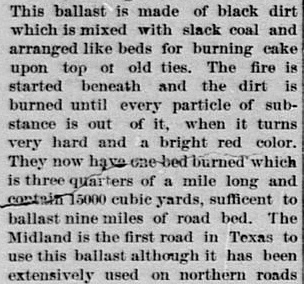
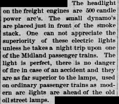
in railroading, yet he brought numerous innovations to Texas, starting with two beds built north
of Kaufman in which to produce burnt ballast. Its hardness and water absorption
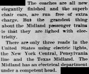
properties improved the roadbeds through the "black gumbo" soil in east Texas for faster and smoother passenger travel. Green
was the first in Texas to employ dynamos on the smoke stacks of his
locomotives to produce electrical power for the train's headlights and
to light its passenger cars. He also began using steel
boxcars to improve freight handling and reliability. |
 |
 |
 |
In 1901, a new state law took effect authorizing RCT to manage the safety aspects of grade crossings of two
or more railroad companies (it also had jurisdiction over grade-separated
crossings, but found little need to promulgate such regulations.) RCT
immediately ordered all grade crossings outfitted with swing gates pending the installation of interlocking plants. Even at gated crossings, the
law continued to require that all trains stop before crossing another railroad at grade.
This was later changed to allow trains to approach gated crossings at restricted
speed such that a full stop could be accomplished if the gate was observed
to be lined against the train. The crossing in Kaufman was addressed relatively
early with Tower 39 approved for operation by RCT on June 16, 1904. The tower is
known to have been 15 ft. 8 in. by 12 ft. 6 in size, indicative of a typical
2-story, manned facility. Its mechanical interlocking plant built by Union
Switch & Signal Co. initially had only ten functions, two fewer than the
standard twelve functions of a basic crossing.
 |
Left: SP used this form
(courtesy Carl Codney collection) to record a summary of the functions
and expense sharing for each interlocking plant in which they had a
financial interest. This one, for Tower 39 at Kaufman, was originally
drafted on January 15, 1904, five months before the plant became
operational. The form was amended and retyped over a period of ~ 25
years to incorporate various revisions, most notably that the
interlocker was taken out of service on April 9, 1928, a move T&NO
made as soon as SP had acquired the TM. Comments in the
REMARKS column state that the plan for the interlocker was dated
September 30, 1907, more than three years after Tower 39 became
operational. This was perhaps merely an "as installed" update to the
drawing to incorporate any changes that had occurred during installation and
initial operation.
Of particular significance is that the form
was "Revised effective Jan. 19, 1924 account installation of
movable point crossing frog." An earlier version of the form showed
Levers 5 and 6 blank, reserved as spares. The addition of two moveable point
frogs and two facing point locks onto these spare levers
indicates that the crossing was redesigned to eliminate a fixed diamond
in favor of two switches and a short section of shared track. RCT's list
of active interlockers dated December 31, 1923 raised Tower 39's
function count to twelve, undoubtedly related to these changes which would
take affect in January. Although the form shows fourteen functions, they
are assigned to twelve levers. Prior to the change, there were ten
functions controlled by ten levers.
The form lists only two
distant signals; a basic crossing had four, one in each direction on
both tracks. This accounts for the initial function count being ten
instead of twelve. For Kaufman, the passenger depots being only 0.42
miles south of the crossing eliminated the necessity for distant signals
farther south. When approaching from the south, trains did not need to
know if the interlocker was lined against them because they
would always slow and most often stop at the stations anyway (even
freight trains that might otherwise not need to stop in Kaufman would
slow and perhaps
stop to take on water.) Trains would either be stopping at the
station or moving slowly in its vicinity, hence they could depend on the
home signal to advise the status of the interlocking when approaching
from the south, eliminating the need for a distant signal.
One
peculiarity on the form is that TM is listed as the SENIOR COMPANY. The
Texas Trunk arrived in Kaufman first (1881), and it is apparent from the depot locations that
the track had already passed
through the future crossing site prior to the arrival of the Texas
Central in 1882. The tracks of the Texas Trunk and Texas Central became
owned by T&NO and TM, respectively, but as corporations operating in
Kaufman, TM preceded T&NO.
Typically, SENIOR COMPANY status
was important only for crossings established after 1901 because it
impacted the capital outlay for the tower and interlocking plant. Since
the Kaufman crossing existed prior to 1901, by rule the capital expenses
would be shared equally by both railroads. The form shows the tower was
operated and maintained by the TM. The recurring costs were shared 50/50
because each railroad used half of the interlocking functions.
Typically, the railroad that operated and maintained a 2-story tower was
also the one that had designed and built it. TM had no experience with interlocking
towers so Green might have asked SP to take the construction lead. The
costs would be shared equally either way, and it would have provided TM
with the opportunity to observe the process and be prepared to handle
operations and maintenance. Due to SP's
familiar tower
architecture, a photo of Tower 39 would confirm whether SP led the
construction effort, but none has been found. |
After the 1928 acquisition, T&NO operated the former TM
tracks in both directions from Kaufman, but they
gradually became unnecessary for SP. In 1933, SP gained control of the Cotton
Belt and immediately abandoned TM's Greenville - Commerce track segment built in 1921;
all traffic used the parallel Cotton Belt tracks. Much of Texas Highway 224 sits
atop the abandoned TM right-of-way (the former Cotton Belt tracks are
still operational.) The remainder of the TM line was abandoned in phases
beginning with the tracks from Ennis to Kaufman in 1942, followed by the segment from Kaufman to Greenville in 1958. The former TM
tracks between Commerce and Paris survived until abandonment by SP
in 1975. On the original (ex-Texas Trunk) T&NO line
through Kaufman, operations continued until 1981 when 137 miles between Bonita Junction (near
Nacogdoches) and Seagoville (near Dallas) was abandoned. Since then, there have
been no active
tracks in Kaufman.
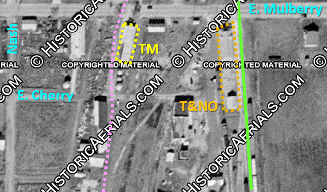
These aerial images of the
Kaufman crossing (right)
and depots (below)
were taken in 1957
((c) historicaerials.com), long after the former TM tracks to the south had
been abandoned by T&NO. Hence, this image shows no tracks on the TM
right-of-way (pink) south of the crossing. The TM and T&NO lines
approached the crossing nearly parallel, resulting
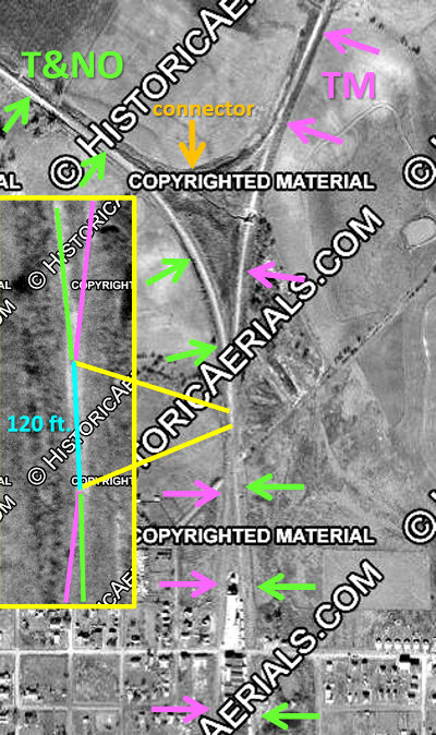
in a highly acute angle for the diamond. The addition of movable
point frogs and facing point locks on January 19, 1924 indicates the railroads chose
to remove the diamond in favor of a straight track with
switches at each end (this has since been done
elsewhere.) A movable point frog is a switch
point located where the diverging rails connect that rotates
slightly to produce superior
wheel support and reduced maintenance costs.
A facing point lock is used to physically lock a switch point within
specific tolerances against the rail, improving reliability. Analyzing the magnified aerial image produces a
"best guess" of at least 120 ft. of straight track between the
two switches.
The T&NO depot was used for both
lines after the TM acquisition in 1928. Since Tower 39 is known to have
been retired at that time, it is likely that the south switch was taken
out; only the T&NO track (green) was needed to reach the depot. The
interlocker was removed because the crossing no longer
existed; it had become simply a straight track with one switch on the
north end. Until 1942 when the Ennis line was abandoned, a
crossover between the TM and T&NO tracks south of the T&NO depot
facilitated train movements to or from the Ennis line. The TM tracks north to
Greenville were abandoned in 1958 and the north switch was removed.
 |
 |
 Left:
A snippet of the 1920 Sanborn Fire Insurance map of Kaufman showing the two
passenger depots has been superimposed on a Google Maps satellite image dating from 2021.
The TM
and T&NO railroad stations were across from one another about a hundred
yards apart immediately south of Mulberry St. There was no Union Depot, despite
a lawsuit filed in 1891 to force construction of one. The T&NO map at the top of the
page shows a more comprehensive view of the tracks near the depot, including
additional crossover tracks south of it.
Left:
A snippet of the 1920 Sanborn Fire Insurance map of Kaufman showing the two
passenger depots has been superimposed on a Google Maps satellite image dating from 2021.
The TM
and T&NO railroad stations were across from one another about a hundred
yards apart immediately south of Mulberry St. There was no Union Depot, despite
a lawsuit filed in 1891 to force construction of one. The T&NO map at the top of the
page shows a more comprehensive view of the tracks near the depot, including
additional crossover tracks south of it.
The T&NO main line right-of-way has been repurposed as a city street,
Old Rail Rd. On the south side of both depots, Cherry St. appears as a vague
dirt path in the 1957 imagery above, but it was never established as a public
road east of Nash St. and there's no trace of it now.
The TM depot was
no longer needed after TM's acquisition by T&NO in 1928, but it continued to
stand until at least 1962 based on historic aerial imagery. This was presumably
the same TM depot that
the
Houston Daily Post of November 20, 1899
briefly mentioned as having been recently finished. A 1948 update to the 1920
Sanborn Map shows that it had been repurposed as "Hay & Feed W. Ho." The next available aerial imagery
is from 1981 by which time the T&NO depot was definitely gone and the TM depot
had either been cut back to a much smaller building or replaced by one. No information
has been found regarding the demise of either depot.
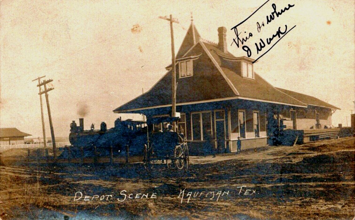
| Right:
This undated photo from the Dennis Hogan collection shows the front
(north) and west side of the TM depot. The photographer was standing on
Mulberry St. looking south-southeast. The elevated platform visible to
the right indicates the west side of the depot was used for freight.
The south end of the T&NO depot can be seen in the distance at left. |
 |
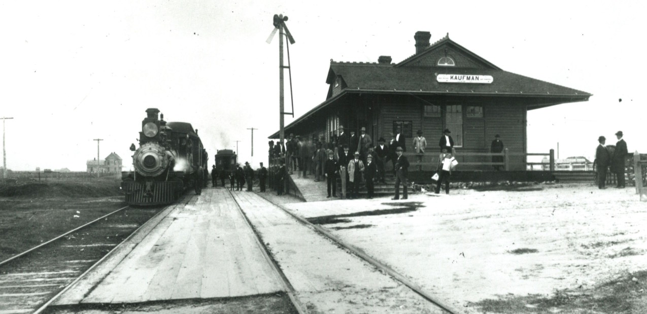
Above: This undated photograph
of the T&NO depot in Kaufman is from DeGolyer Library (Dennis Hogan collection),
photographer unknown. Notes on the photo state that the locomotive is SP #135,
which had originally been Galveston, Harrisburg & San Antonio Railway #34. The
view is toward the south from the Mulberry St. grade crossing, assuming that the
street actually existed at the time. The long side roofline suggests that the
depot's length was roughly twice its width whereas the 1920 Sanborn Map depicts
a longer depot. The photo probably dates from the very early days of T&NO
operations in Kaufman c.1903. Despite the longevity of the T&NO depot, this is
the only photo of it found so far (thanks, Dennis!)

Above: Looking southwest, this
Google Street View image shows the street signs at the intersection of E.
Mulberry St. and Old Rail Road. The building and parking lot
occupy the site of the T&NO passenger station.
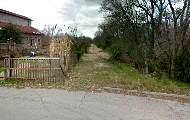
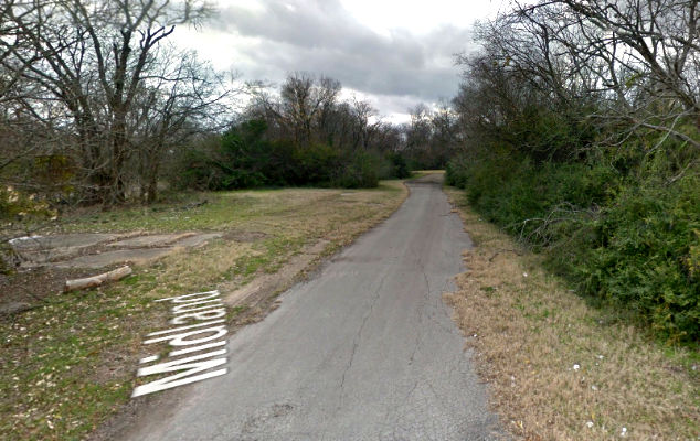
Below: Approximately 1,100 ft. north
of the depots, both railroads crossed East 1st North St. at
grade. The Google
Street View at left looks north along the T&NO right-of-way.
The view at right looks south along the TM right-of-way
which is approximately 135 ft.
west of the T&NO right-of-way at this point. Google Street View superimposes
the street name, Midland, and there are numerous railroad-related concrete foundations.