Texas Railroad History - Tower 58 - Alvarado
A Crossing of the Gulf, Colorado & Santa Fe Railway and the
Missouri, Kansas & Texas Railway
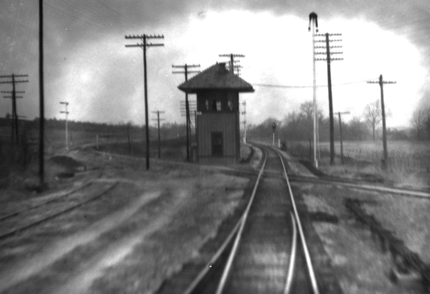
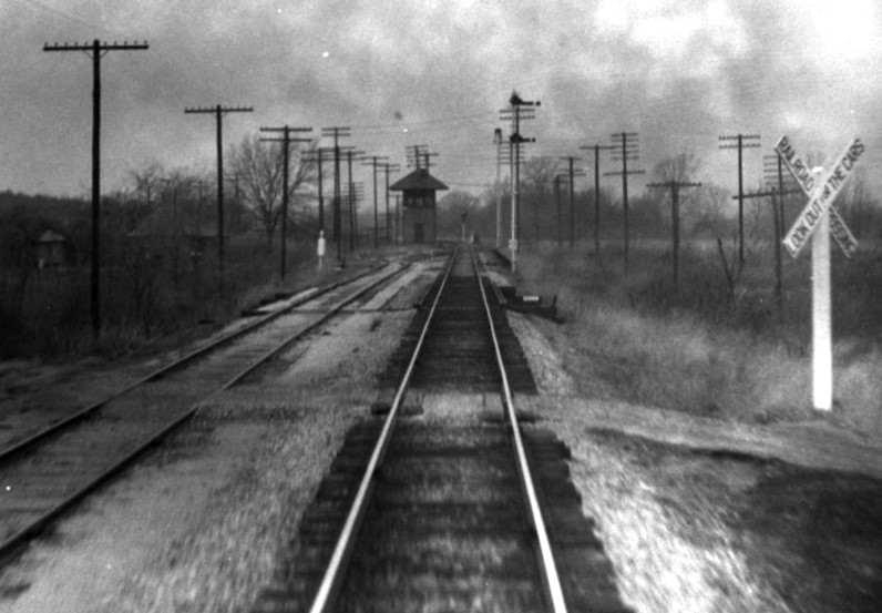
These two photos were shot sequentially from the rear platform of John W
Barriger III's business car, probably in the late 1930's or early 1940's, as he
headed south through Alvarado toward Waco. Both are views of Tower 58 looking
northwest along the Missouri - Kansas - Texas Railway [MKT, known prior to 1923 as the
Missouri, Kansas & Texas (MK&T) Railway, but it was
always "the Katy".] In the photo
above left, the Gulf, Colorado
& Santa Fe Railway tracks cross at an angle in the foreground. To the left of
the tower, the Santa Fe curves back to the northwest beside the Katy. Note the exchange
track at far left which comes off the Santa Fe near the tower and parallels the
Katy to the south. The tracks in the immediate foreground show that Barriger is directly above
a switch for a short connecting track
that went to his left and merged into the exchange track. At the far south end,
the exchange track merged into the Katy. This provided maximum switching
flexibility for the Katy, allowing trains in either direction to move cars on or
off the exchange track easily. Above right,
Barriger's photo taken a few seconds later shows a better view of the exchange track. The short connecting track is
barely visible in the distance where the
exchange track begins its curve to the left to join the Santa Fe.
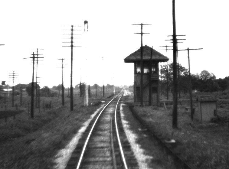 |
Left: This photo of Tower 58 was taken by Barriger
looking south down the Katy on a different trip. The Santa Fe track crosses behind the tower and the switch
for the short connector to the exchange track is vaguely visible just beyond the diamond.

Above:
This excerpt from a 1945 Santa Fe employee timetable (ETT) describes the
semaphore signals controlling Santa Fe access to the exchange track.
Below: In the
Barriger photo above left, the semaphores are visible along the left
side.
On the image at left, they are just off the right edge.
 |
Alvarado, reportedly named by the local sheriff for a
town in Mexico, has existed since the early 1850s, pre-dating the arrival of the
railroads by thirty years. The town did not incorporate until 1878 when plans
for railroads through the vicinity were being promoted by various interests. Locals began
to anticipate rail service in the mid 1870s, but it did not materialize until July 26, 1881.
Technically, the first tracks into Alvarado were owned by the Missouri, Kansas
& Texas ("Katy") Railway coming south out of Fort Worth,
but the Katy was under
lease to the Missouri Pacific (MP) Railroad at the time and all track
construction was publicized as MP activity. MP was controlled by rail baron Jay
Gould who had been named President of the Katy in December, 1879 after a lengthy
effort to infiltrate Katy executive ranks with Gould loyalists. With little
personal ownership of Katy stock, Gould could best reap the benefits of its
profitability by leasing the Katy (in December, 1880) to MP which he controlled
through a large ownership position acquired in 1879. MP was based in St. Louis
and did not have a presence in Texas, but it
controlled a major line between Texarkana and St.
Louis through the St. Louis, Iron Mountain & Southern (SLIM&S) Railway,
an Arkansas / Missouri railroad. Its management had capitulated to Gould's 30%
ownership and allowed it to be leased by Gould to MP. The Katy lease
used
accounting policies tilted heavily toward MP, enabling MP stockholders (Gould in
particular) to enjoy Katy profits siphoned into MP at the expense of Katy
stockholders (who were not happy when they
eventually figured out what was happening.)
MP lacked a
Texas headquarters and a Texas railroad charter, hence the title to all of MP's
new track construction was assigned to the Katy. The Katy
also lacked both of those items (it was headquartered in Kansas) but it
did have permission granted by a Texas law passed in 1870
that allowed it to rely on its
Kansas charter for the privilege of building into Texas across the Red River at
Denison. The law also allowed the Katy to build
"...in the general direction of Waco and Austin, to the Rio Grande..." The
headquarters requirement had been added to the Texas Constitution in 1876, but
Gould was unfazed -- the 1870 law was still on the books and he would rely on it
if anyone questioned his right to build MP (Katy) tracks in Texas. Gould also
knew that politicians were not interested in finding reasons to
stop railroad construction; they always wanted
more railroads, and he was happy to oblige.
The Katy had bridged the Red River into
Denison in late 1872, but little additional construction was
accomplished during
the remainder of the decade. That changed significantly with Gould in
control. MP (Katy) reached Fort Worth from Denison in the spring of 1881,
and Gould directed that the effort continue south toward
Waco, Temple
and Taylor. It was this construction that
brought MP (Katy) rails to Alvarado in July, 1881.
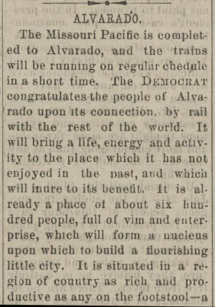
Right: The
Fort Worth Daily Democrat
of July 26,
1881 celebrated the arrival of the MP tracks into Alvarado. As always
under Gould, the Katy's name was nowhere to be found.
Left: The
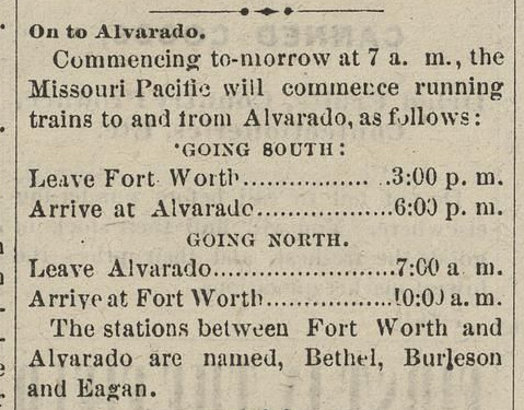
commencement of MP passenger service between Fort Worth and Alvarado was published by the
Fort Worth Daily Democrat
of August 7, 1881.
Farther south, Gould sent construction crews to
Waco to establish rights-of-way and to begin building the Brazos
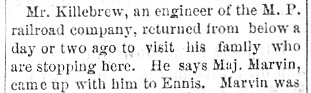
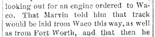
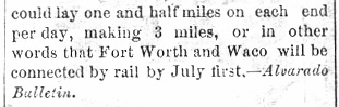
River bridge into downtown. There was a plan to lay tracks north from Waco (noted
below
in the Fort Worth Daily
Democrat of June 7, 1881 quoting the
Alvarado Bulletin) but no
evidence has been found to show that any track-laying was performed in a
northerly
direction.
 |
 |
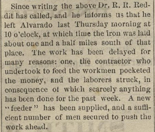 |
Left: MP
(Katy) track-laying continued south from Alvarado. The
Fort Worth Daily Democrat of August
2, 1881 quoted a correspondent reporting that "...iron was laid about one and
a half miles south of that place."
The next major town
south of Alvarado was Hillsboro; tracks
reached the town in September. The Fort Worth
Daily Democrat of October 11, 1881 reported that the first round
trip passenger train to Hillsboro had returned to
Fort Worth
"...bringing quite a number of passengers." Waco was next, 32 miles
from Hillsboro, and the tracks arrived in East Waco in mid December. The
first construction train crossed MP's new Brazos River bridge into
downtown Waco on December 22, 1881. |
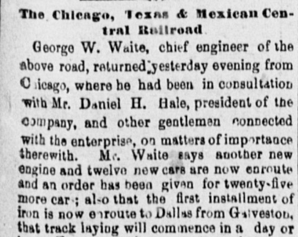
Long before MP (Katy) built from Denison to Fort
Worth and continued south, the Chicago, Texas & Mexican
Central (CT&MC) Railway had been trying to build a rail line from
Dallas to
Cleburne via Alvarado, a lengthy saga best told
elsewhere. The first Dallas - Cleburne charter dated to 1876, and Fort Worth
newspapers had long ridiculed the CT&MC and its predecessors' poor
attempts to build the line. This was another manifestation of the
obsession that Fort Worth (or at least its newspapers) had with Dallas
as a railroad rival. It
was mostly scorn derived from a jealous lament that no investors
had stepped up to build a Cleburne - Fort Worth line, a much shorter
distance. Fort Worth newspapers joked frequently
about the CT&MC's numerous grand pronouncements of planned work on the
Dallas - Cleburne line, most of which never materialized. The idea that
the CT&MC would become the key middle segment of a Chicago to Mexico
City rail line was laughable.
Right: In this note
from April 19, 1881, the Fort Worth Daily Democrat
had snide commentary on a recent editorial by the
Alvarado Bulletin
(reproduced in full) anticipating the
construction of the CT&MC. The
Alvarado Bulletin
had only recently begun publication and it was related to the
Cleburne Bulletin
which had been founded in August, 1880 by Andrew Julian Byrd, hence the
"Byrd singing" reference to his prior criticism of the CT&MC's
lack of progress. Byrd left the newspaper business when the
Cleburne Bulletin
was sold in November, 1880, and he died in October, 1881, not living to
see the CT&MC reach Alvarado.
In the summer of 1880, the Gulf, Colorado & Santa Fe (GC&SF) Railway
chose Fort Worth to be the terminus of its Northern Branch
(from Temple) with a route via Cleburne. GC&SF grading had commenced
from
Fort Worth south toward Cleburne and the Brazos River in November, 1880, but
full construction and track-laying only went north out of Temple. GC&SF tracks reached Cleburne
at the end of October, 1881 and by Thanksgiving, its tracks were
"within six miles" of Fort Worth and "...will reach this place
by December 1st." (Fort Worth Daily
Democrat, November 25, 1881.)
|
 |
 |
To collect a bonus, the CT&MC was racing to complete fifty miles of
track from Dallas toward Cleburne by the end of 1881. From Alvarado, the
remaining distance to Cleburne was approximately thirteen miles of which
ten needed to be complete by December 31. That the CT&MC completed its
required fifty miles of track on the last day of 1881 (and earned its
bonus, either $40,000 or $50,000, depending on the newspaper account)
suggests that work trains were operating through Alvarado by mid
December.
Left:
The Dallas Daily Herald of
December 27, 1881 quoted an Alvarado
Bulletin announcement of the completion of the CT&MC line
into Alvarado. Perhaps this represented the start of limited Dallas -
Alvarado service since work trains had to have been passing through
Alvarado and nearing Cleburne well before this date.
Suffice to say that despite numerous corporate missteps
along with various operational and financial difficulties, the CT&MC was
ultimately a successful rail line, but only because it was procured and rehabilitated by the much larger (and vastly more
capable) GC&SF. The GC&SF
wanted the rail line for service to Dallas, but also had the intention of
continuing the line northeast to Paris which was
expected to become the southern terminus of a St. Louis & San Francisco
("Frisco") Railway line from Missouri. This would ...someday...
make Paris another Midwest gateway for Texas (the other two, Denison and
Texarkana, were effectively controlled by Gould.)
|
At Cleburne, work on the GC&SF / CT&MC track connection did not finish until
January 7. On January 8, 1882, the GC&SF schedule advertisement
in the Fort Worth Daily Democrat began to list
a connection "At CLEBURNE, with C. T. & M. C. Ry. for Alvarado, Dallas and
all points on that line." There were reports that the two railroads had
also agreed on railcar interchanges, mail routes and other elements of railroad
cooperation.
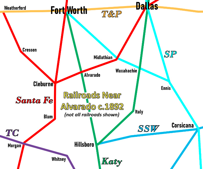
Right:
Rail lines near Alvarado c.1892 (not all rail lines shown)
The GC&SF bought the CT&MC in July, 1882; its assets (the Dallas - Cleburne rail line and little else) were
absorbed into the GC&SF which instituted successful service to Dallas over
the line. The GC&SF
extension to Paris was accomplished in 1886, one of three specific projects the
GC&SF had to perform as part of an agreement to be acquired by the much larger
Atchison, Topeka & Santa Fe Railway under favorable terms (the
others were an extension from Fort Worth to Purcell, Oklahoma and a line
from Cleburne to Weatherford.) The GC&SF
became a wholly-owned subsidiary of AT&SF in 1887, and because of the common
term in both railroads' names, everyone just called it Santa Fe. In
addition to the Katy and Santa Fe lines, others that appear on this map
are:
Southern Pacific (SP)
- large western railroad system that began to acquire Texas railroads in
the early 1880s; the line through Dallas went from
Houston to Denison
where it connected with the Katy
Texas & Pacific (T&P)
- major railroad taken over by Gould in 1881; Gould completed the
segment from Fort Worth to
El Paso by negotiating to share SP's track
west of Sierra Blanca
St.
Louis Southwestern (SSW) - more commonly known as the
Cotton Belt. The main line from
Texarkana to Corsicana continued to
Waco with a branch line to Hillsboro. The SSW became a Gould railroad in 1891,
run by his son Edwin for 30+ years
Texas Central (TC) - main line from Waco to
Albany crossed the Santa Fe at Morgan; it became part of the Katy c.1914
In addition to Tower 58 at Alvarado, interlocking towers were
eventually located at Morgan,
Hillsboro,
Cleburne, Midlothian,
Waxahachie, Italy
and Corsicana, in addition to numerous such
towers in Fort Worth and
Dallas. |
 |
 |
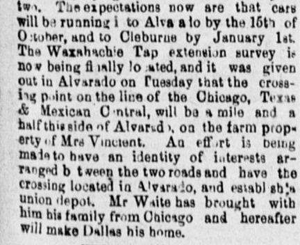 |
Left:
(Dallas Daily Herald, August
4, 1881) There was a persistent rumor that the Waxahachie Tap Railroad
would extend its tracks from Waxahachie west to Alvarado and Cleburne
and continue northwest to Weatherford. Although the idea of a Cleburne -
Weatherford line had value and was eventually built by Santa Fe, the
rest of the "plan" made no sense. To avoid duplication, presumably the
Tap intended to use trackage rights on the CT&MC between Alvarado and
Cleburne (perhaps the "effort ... being made to have an identity of
interests arranged between the two roads...".) If so, the Alvarado
junction would be a switch, not a crossing (and if not, the two
railroads would be competing in the Alvarado - Cleburne market.) The
idea that the Tap would cross the CT&MC "a mile and half this side of
Alvarado" (presumably east) is also problematic. Waxahachie was south of
the CT&MC line and Cleburne was slightly farther south; there didn't
need to be a crossing at all. Like many such reports related to the
CT&MC, nothing ever happened. |
In May, 1888, Katy stockholders were finally able to
summon a quorum to a special meeting at which they fired Gould for malfeasance
associated with the MP lease. The new Katy management
immediately sought bankruptcy protection and asked that MP's lease be revoked. In 1890, the Texas Supreme Court affirmed a
lower court's order dissolving the MP lease, but it confirmed that the Katy was
still a "foreign" railroad because it lacked a Texas charter and a Texas
headquarters. To solve the problem, a new state law in October, 1891 chartered the Missouri, Kansas
& Texas of Texas Railway with a headquarters at Denison, a wholly-owned subsidiary of the parent Katy
railroad. For nearly the next hundred years,
the Katy remained independent until it was acquired by Union Pacific (UP)
in 1988. UP had purchased MP in 1982, so the Katy was integrated into MP,
reuniting the two railroads nearly a hundred years after MP's lease had ended.
In 1901, a new state law gave the
Railroad Commission
of Texas (RCT) the authority to mandate safety systems for all railroad crossings,
and to dictate whether crossings would be "at-grade" or "grade-separated". The Alvarado crossing
at grade was interlocked on November 21, 1904 when Tower 58 was commissioned for
operation with a 20-function mechanical interlocker. Twelve was the standard
minimum function count, so the additional functions most likely pertained to
switches,
signals and derails for the exchange track visible in Barriger's photos. RCT documentation states that the interlocking tower was installed
by the Katy, which also had responsibility for staffing it. Since the crossing
existed prior to 1901, the railroads would have split the capital cost of the
tower and interlocking plant. They would also share the recurring maintenance and
operations costs on a "weighted function" basis. The precise
interlocking function
allocation is unknown, but the sharing for Tower 58 would likely have been
50 / 50, or close to it.
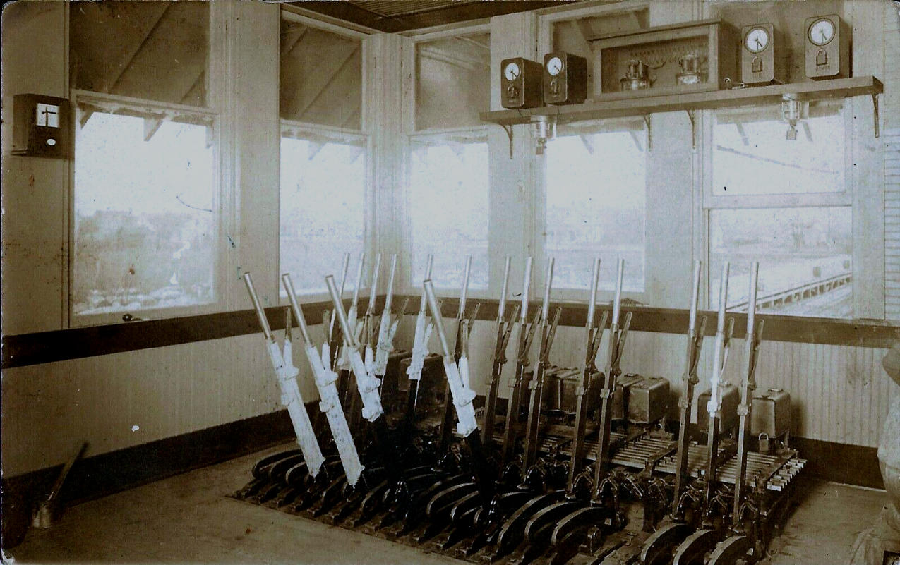
Above: interior view of the
mechanical "armstrong" levers for Tower 58's interlocking plant c.1910 (Dennis Hogan collection)
Alvarado had existed for three decades before the
railroads arrived and this affected the choice of rights-of-way. There were
approximately 400 people in Alvarado in 1880, sufficient population to make
building through the town too expensive for the benefit gained. MP chose a route that passed along the west side of Alvarado and they
built their depot three quarters of a mile southwest of downtown. The location
was inconvenient, but the town did grow toward the depot. For the CT&MC, the
natural route would have been across the north side of town, but they chose to
make a right angle curve to the south to pass a quarter mile east of downtown
where they located their depot. The tracks continued south for a short distance,
made a long sweeping curve back to the west, and then angled northwest to cross
the Katy just under a mile southwest of downtown. The crossing was at an acute
angle, about 0.9 miles north of the Katy depot.
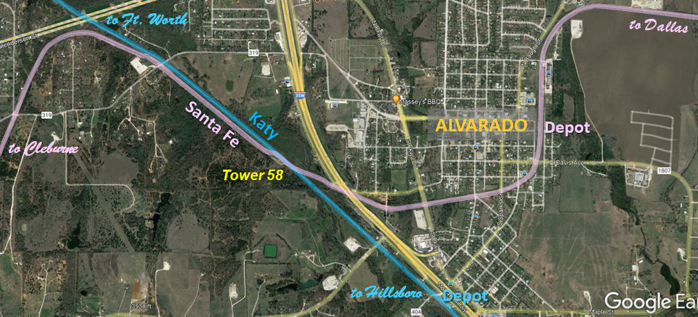
| Right:
This post-1996 satellite image of the vicinity of Alvarado has been annotated to show the rail
lines, depot locations and the site of Tower 58. Having elected to curve around the south
side of town, the CT&MC could have proceeded west-southwest directly to
Cleburne (which has a latitude four miles south of Alvarado's.) That they did not do so suggests that the
decision to build the depot near downtown and curve around the south side of
Alvarado might have been made while construction was in progress, making it easier to return
north and rejoin the planned right-of-way rather than survey a new one and obtain
new easements.
There were no natural barriers on a straight line to Cleburne from the
southwest side of Alvarado, but the CT&MC had
no time to waste due to the critical need to achieve the promised bonus from the city of Dallas. |
 |
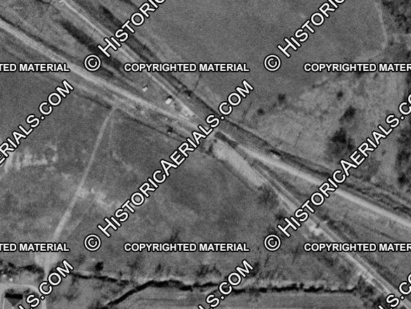 |
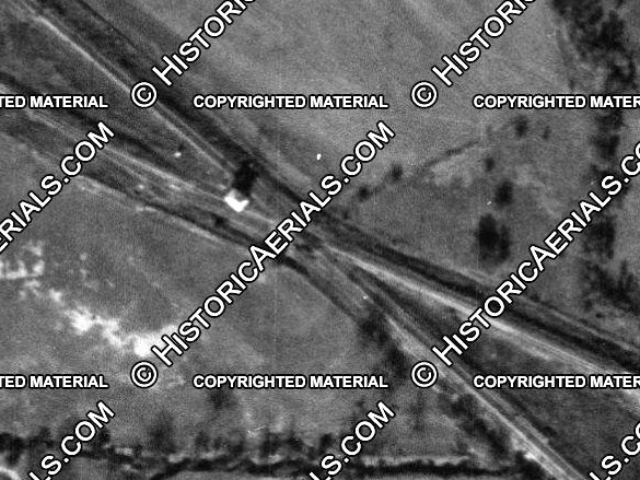
Left: Historic aerial imagery ((c) historicaerials.com) shows that Tower 58 was likely decommissioned
between 1956 (far
left)
where it is clearly visible casting a shadow to the north across the Katy
tracks, and 1958 (near left) where
it is no longer visible. It was replaced by an automatic interlocking
plant. |
In 1995, Santa Fe merged with Burlington Northern to create
Burlington Northern Santa Fe (BNSF), and about a year later, UP
acquired SP. Approvals of both mergers required significant grants of rights
between the two systems to ensure competition since they each controlled a
sizable percentage of Texas rail activity. These requirements may have been the
impetus for changes to the crossing at Alvarado. The diamond was removed in
1996, replaced by two switches and a short section (~ 100 feet) of shared track.
This gave both UP and BNSF the ability to crossover to the other's tracks in
certain directions.
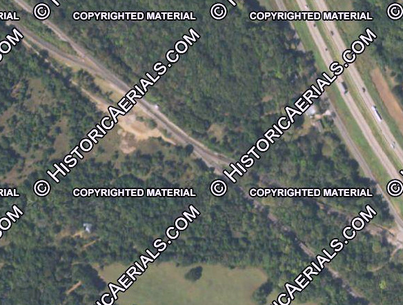 |
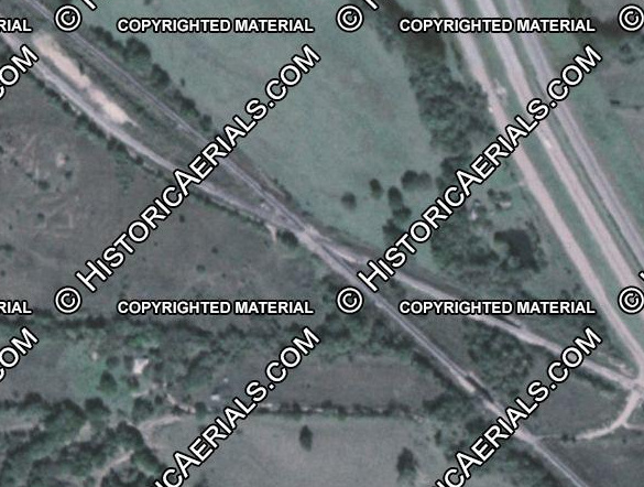
Left: The merger-related track
changes at the Tower 58 crossing are evident in these images ((c) historicaerials.com) from pre-merger
1981 (left) to post-merger
2016 (right). |

Above Left: Looking north, this is the post-merger track
arrangement at the Tower 58 crossing with UP tracks (left) and BNSF tracks
(right) coming south off the bottom of the image. (Jim King photo, c.2005.)
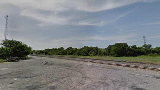
Above Right: The Katy depot
was located here on the east side of the tracks, just under a mile south of
Tower 58. The date it was removed has not been determined. (Google Street View,
2015) Below: photos of the
Alvarado depots from the H. D. Connor Collection.
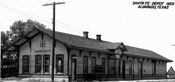

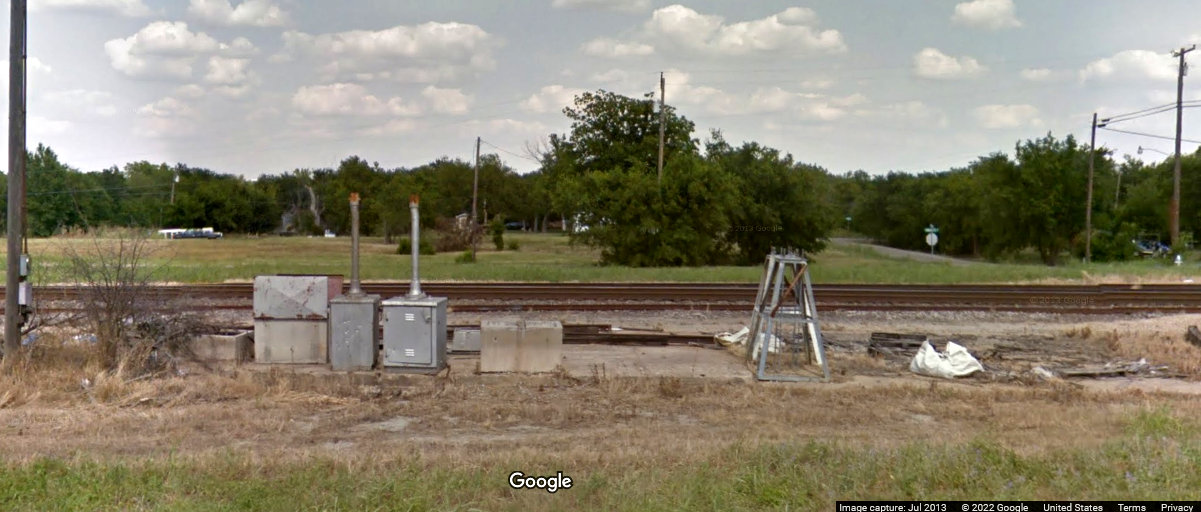
Above: The foundation of the
Santa Fe depot on the east side of Alvardo had become a convenient collection spot for assorted railroad
refuse when this Google Street View image was captured in 2013.
