Texas Railroad History - Tower 35 - Dallas (Hiland)
A Crossing of the Houston & Texas
Central Railway and the
Missouri, Kansas & Texas Railroad
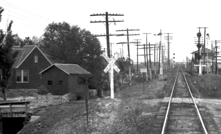
Above Left: This image showing
Tower 35 is cropped from a photo provided by the John W Barriger III National
Railroad Library. The photo was taken by railroad executive John W. Barriger III
from the rear platform of his business car as his train sped southbound toward
Dallas Union Station on tracks of the Missouri - Kansas - Texas ("Katy")
Railway. The date is unknown but it was sometime in the 1930s. The presence of
three-position searchlight signals is consistent with an update to the Tower 35
interlocking plant that became effective on October
9, 1930. The tower was
located a few miles north of downtown Dallas where it controlled the Katy's
crossing of Southern Pacific's north / south main line between Houston and
Denison. Barriger's camera is pointed northeast; from his vantage point, SP's
tracks pass behind the tower. A switch for a northwest quadrant
connector installed in 1916 is visible in the track ahead. Barriger's business car
has just passed over the Airline Road grade crossing in the
foreground, and the house to the left which fronts Airline remains standing
today though substantially updated.
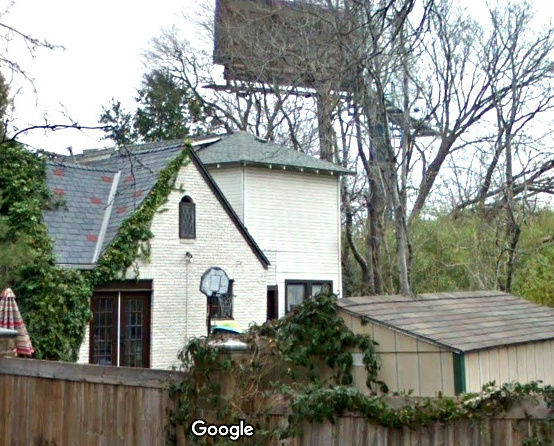
Above Right: This 2017 Google Street View shows the
house in more recent times. Besides the obvious repainting, another major change
is the addition of a tower (with a shape similar to Tower 35) that is
partly occulted by the peaked roof. The rectangular window near the top of the
peaked roof has been replaced with an arched window, and a spotlight has been
installed below it. The two original rectangluar windows on the house have been
replaced by French doors. The outbuilding between the
house and the tracks looks smaller and has a lower roof angle indicating it was
rebuilt or replaced by a newer structure.
When the Houston & Texas Central (H&TC) Railway
built through Dallas in 1872, the town was just a small community along the
banks of the Trinity River in north Texas. The H&TC
construction continued north to Denison arriving
in late 1872 just as a new railroad bridge over the Red River was completed to
bring tracks from the north into Denison. The bridge and the tracks belonged to the Missouri, Kansas & Texas Railway (MK&T but mostly called
the
Katy; the corporate name changed to Missouri - Kansas - Texas in 1923.)
Dallas began to grow rapidly the following year when the Texas & Pacific (T&P) Railway, building from
Texarkana to Fort Worth,
crossed the H&TC at Dallas. Soon, the H&TC and Katy
were cooperating on traffic exchange through Denison, and by 1876, they were
collaborating on
single train passenger service between St. Louis and Houston
via Denison.
The H&TC's operations at Houston attracted the attention of Charles Morgan,
owner of a large steamship line operating in the Gulf of Mexico. Morgan had
made the strategic decision to acquire railroads to improve the movement of goods in and out of the major
ports servicing his steamship line. To this end, he organized Morgan's Louisiana
and Texas Railroad and Steamship Company and acquired a short line railroad
in Houston to serve a new port he was building along Buffalo Bayou at
Clinton. To provide long haul freight service for
his railroad, Morgan purchased the H&TC in early 1877.
Morgan died the following year, and as his massive estate was settled, the
H&TC came under the ownership of Southern Pacific (SP) in 1883.
 |
In December, 1879, rail baron Jay Gould was named President of the
Katy. Gould's election to that position had been carefully orchestrated
by his loyalists who had infiltrated Katy management over several years,
a plot necessary because Gould was unable to procure controlling
interest in the Katy through the stock market (Katy stock was terribly diluted
and there were few large blocks
available for private sale.) A year later, Gould leased the Katy to Missouri Pacifc (MP), a railroad
based in St. Louis in which he held a large ownership position. Gould
needed the Katy as part of his plan to extend his rail empire into Texas
under the MP name. MP had no state charter to build rail lines in Texas
and it was unlikely to be granted one by the Texas Legislature, so the Katy substituted
for MP by owning Gould's tracks and facilities in Texas.
Gould insisted that all construction and
operations (e.g. routes, depots, advertising, etc.) use the MP name publicly even
though the title to new MP tracks in Texas would be held by the
Katy. Gould also needed the lease so that Katy profits flowed into MP's
coffers where he would benefit from dividends on his stock holdings.
In April, 1881, Gould gained financial control of
the T&P and became its President. The T&P already had tracks from Texarkana
to Sherman near the Katy's base at Denison,
so Gould approved
a T&P project to build a line from Sherman to Fort Worth
to be shared with the Katy. The route from Sherman went seventeen miles west to Whitesboro where
the Katy already had tracks from Denison. The T&P and Katy
then shared the Joint Track south from Whitesboro to Fort Worth. The Katy
also had a rail line between Denison and
Greenville. In February,
1886, Gould chartered the Dallas & Greenville (D&G) Railway to build from Greenville to Dallas,
construction publicly attributed to MP even though the D&G was legally independent.
The D&G was acquired on December 2, 1886, the day it officially reached
Dallas. Since MP lacked a Texas charter, Gould directed the Katy to make the
purchase.
The D&G's route into Dallas County was on a general southwest
heading into
Garland toward Dallas, crossing the H&TC at
an acute angle in a rural area about six miles from downtown. The
crossing was on land owned by William Caruth, a farmer and pioneer
settler who owned thousands of acres of land northeast of Dallas' central
business district. The line through Caruth's property was the Katy's
second set of tracks to reach Dallas. In December, 1881, the Katy had purchased tracks from the T&P that ran between Dallas and Denton, a town on the
aforementioned T&P /
Katy Joint Track to Fort Worth.
By 1887, Gould was beginning to have problems with Katy stockholders.
They sought to fire him due to the unfavorable terms of the lease that
effectively transferred Katy profits to MP stockholders. Gould worked to
prevent the stockholders from calling a meeting where they could fire
him, but his delay tactics eventually failed. At a special meeting held in May,
1888, a quorum of Katy stockholders assembled to fire Gould for malfeasance. New Katy management was
elected and they immediately sought bankruptcy protection. In 1890, the
Texas Supreme Court affirmed a lower court order dissolving MP's lease
of the Katy. The Katy would continue to
operate in Texas during its receivership until it could be reorganized pursuant
to a new Texas charter to be enacted by the Legislature, which occurred
in October, 1891. Going forward, the Katy would remain independent for
the next hundred years.
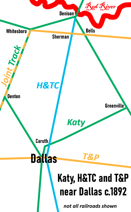
Left: the Katy, H&TC and T&P in the Dallas area c.1892;
other railroads
not shown |
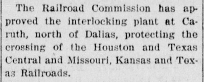 |
Left: The
Denton County News of April 7, 1904
reported that an interlocking plant for the H&TC / Katy crossing
"north of Dallas" had
been authorized for operation at "Caruth" by the Railroad Commission of
Texas (RCT.) In the numbering system RCT used, the 12-function
mechanical plant was assigned #35. RCT's list of active
interlockers published October 31, 1904 reported Tower 35's location as
"Carruth", a misspelling of the family name that was never corrected.
The twelve functions -- the minimum for a typical rural crossing --
consisted of a home signal, distant signal and derail in
each of the four directions. RCT's interlocker list published
October 31, 1915 re-identified Tower 35's location as "Oasis", the name of
a community a mile northeast of the tower. The list published
a year later showed the function count had increased to eighteen. This
was due to a new connecting track built in the
northwest quadrant of the diamond. |
The connecting track in the northwest quadrant of Tower
35 pertained to the development of Dallas Union Station, though the station was
six miles away. The lack of a true union passenger station in
Dallas was a sore spot for city leaders and for RCT, which sued the City of
Dallas over this issue in 1910. In March, 1912, eight railroads serving Dallas
agreed to a plan to construct Dallas Union Station at the west
end of downtown under the auspices of Union Terminal Co. (often called Dallas
Union Terminal, "DUT"), a newly chartered railroad company owned equally by the
H&TC and seven other railroads.
To the public, Union Terminal Co.
was focused on the design and construction of Dallas Union Station, but the company also
had to redesign the track layout in the west end of downtown
so that passenger trains of all of the owners of Union Terminal Co. could access the new station.
As
Dallas continued to grow, the T&P and H&TC tracks through the central business
district had begun to cause safety and traffic congestion problems. The two
railroads shared a passenger depot at their downtown crossing, and a third
railroad, the Texas & New Orleans (T&NO) also used the station via trackage
rights on the T&P. (The T&NO was a subsidiary of SP that operated a line to
Beaumont.) Trains were often stopped at the station
for lengthy periods, blocking downtown streets. Safety was a concern due to the large number of pedestrians,
wagons and
other vehicles moving in close proximity to the tracks. There was a desire by all parties to couple the
development of Dallas Union Station with a related project to establish a means
for T&P and SP trains
to bypass downtown yet still serve the new station. Two railroad bridges from downtown
extending west over the Trinity River (owned by
the T&P and the Chicago, Rock Island & Gulf, respectively)
complicated the situation, thus the layout had to accommodate substantial freight
traffic passing the new station. The eventual solution was creation of the Dallas
Belt Line, which provided a bypass around much of the central business district.
DUT
was also given responsibility for switching services throughout much of Dallas resulting in construction
of new spur tracks, connecting tracks and sidings. One of the connecting
tracks built by DUT was the northwest quadrant connector at Tower 35 to support
switching services farther north. Interlocking functions added to the Tower 35 plant for this connector were attributed
to DUT, so on October 8, 1916, it
began sharing the recurring cost of the tower's operation and maintenance (O&M), one week before Dallas Union Station opened officially
on October 14, 1916. Recurring costs for tower and interlocker maintenance
consisted of replacement parts and equipment, building materials, and skilled
labor to perform the maintenance. Recurring costs for tower operations consisted
of operator labor, office supplies and utilities.
The new station was on the west
end of downtown while the H&TC main line ran north / south more than
a mile to the east. The H&TC needed a feasible route to reach the new station
while respecting the desire to minimize tracks through the central business
district.
The northwest connector at Tower 35 served this purpose, and H&TC trains began
accessing Dallas Union Station to and from the north using rights granted over
the Katy's tracks between the station and Tower 35.
 |

Above: This track
chart of Dallas was drawn in 1915 by the Office of the Chief Engineer of
the Katy railroad. Color annotations have been added to highlight
specific railroads; various interlocking towers are labeled with blue
dots. The two SP railroads (H&TC and T&NO) are highlighted in orange,
the T&P is in dark blue and the Katy is in green. The Gulf, Colorado &
Santa Fe Railway is highlighted in red (not all railroads are
highlighted.) The chart shows there was a connecting track in the
southeast corner of the Tower 35 crossing. The northwest connector is
not shown because it was built a year after the track chart was
drawn.
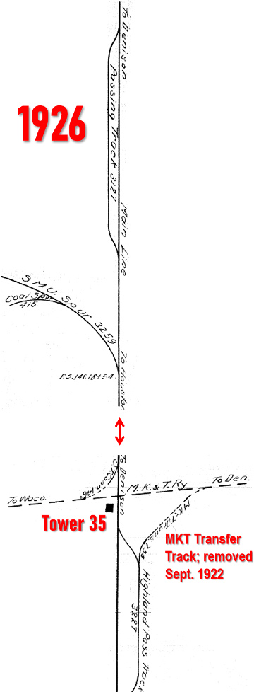
Left:
Two 1926 track charts (Carl Codney Collection) are concatenated
vertically to show the Tower 35 crossing and a spur onto the SMU campus farther north.
The charts were originally oriented with North to the left, hence some
of the lettering is now upside down. The chart shows that a southeast
quadrant exchange track (construction date unknown; removed in 1922) had
connected to H&TC's "Highland Pass Track" rather than the main line, consistent with its purpose as an
interchange track. In contrast, the northwest connecting track (labeled
upside down as "U.T. Conn. 146' ") was switched directly from both main
lines, consistent with its purpose of switching operational trains
between the two tracks. |
The northwest connector at Tower 35 solved the H&TC's problem for
north side passenger train access to Dallas Union Station, but it did nothing for south side access,
e.g. for trains to and from Houston. The solution was complicated, as explained
by noted SP historian, Dave Bernstein ...
The H&TC
purchased a property known as the �Rock Island Dump� in south Dallas in 1913,
extending from near Forest Avenue southeast to
present day Belt Junction [Tower 118]. This right of way was two miles
long, constructed in 1902 when the Chicago, Rock Island & Gulf Railway was
planning an extension south of Dallas. Rock Island completed grading before
the project was abandoned and the �dump� was sold to the Southern Traction
Company who sold it to the H&TC in February 1913 for $15,000. The �dump� became
the first piece of the Dallas Belt Line. The H&TC constructed a double track
railroad in 1918 from Forest Avenue south to the H&TC main line at Belt Junction
which allowed H&TC passenger trains to access the Union Terminal Co. [Dallas
Union Station]. From October, 1916 until completion of the double track
between Belt Jct. and Forest Avenue, H&TC passenger trains operated on the
original H&TC line to Central Junction [Tower 10] thence on the Gulf,
Colorado & Santa Fe Railway to the GC&SF South Junction
connection with Union Terminal Co. [at
Tower 19.]
[Note:
The "Rock Island Dump" became available because Rock Island CEO B. F. Yoakum was
able to negotiate trackage rights between Dallas and
Waxahachie on the Katy for the Trinity & Brazos Valley (T&BV) Railway,
which was half-owned by Rock Island. The T&BV was building a main line between
Dallas and Houston (opened in 1907) for which use
of the
Katy tracks to Waxahachie saved Yoakum considerable right-of-way and construction costs. Although Yoakum
was retired from railroading by the time Union Terminal Co. was chartered, the
T&BV and Rock Island were two of its eight owners. Another owner was a former Yoakum
railroad, the St. Louis & San Francisco ("Frisco") Railway,
which had begun sharing the Katy's Red River bridge at Denison and had built
south to Carrollton in 1902. It began sharing Rock
Island's new track from Carrollton to Irving, continuing to Dallas, in 1908.]
As it did each October 31st,
RCT published its annual list of active interlockers for 1916. It then
republished the list on December 31, 1916, and all future lists were dated the
end of December. The 1916 list added a new feature identifying the railroad that operated each
interlocking tower. For Tower 35, it was the H&TC. And since the crossing
had existed prior to Texas' 1901 interlocker law, RCT's rules required the Katy
and H&TC to pay equal shares of the capital cost of building and equiping the tower.
[At post-1901 crossings, the "second railroad", the one that created
the crossing, bore the entire capital expense.]
Regardless of the capital cost allocation, the railroads were free to decide
which railroad would take the lead for design and construction. It is apparent
from the visual appearance of Tower 35 in Barriger's photo (resembling many other SP
towers in Texas, e.g. Tower 21,
Tower 26, Tower 81)
that the H&TC was the lead railroad for Tower 35. Although DUT began paying
a share of Tower 35's O&M costs in October, 1916, it was not until 1924 that RCT's annual list
named DUT among the railroads sharing Tower 35.
The railroads would also
negotiate a contract to specify the cost sharing formula for O&M, and to
determine which railroad would handle operations and which would handle
maintenance. Typically, the lead railroad handled both, but there were
exceptions.
Railroads would revise these O&M agreements for functional changes to the
interlocking plant (which usually affected cost sharing) and, in some cases,
when adverse financial situations (e.g.
receivership) might impact staffing or traffic levels. [The busiest
railroad at a crossing might not be the tower's lead railroad, but it had the greater interest in
guaranteeing uninterrupted operations across the diamond.] In the vast majority
of cases, the O&M sharing formula was the same: each railroad's share of
recurring costs was the same as its share of the interlocker's total functions.
The railroad with O&M responsibility would bill the other railroad(s)
periodically for their share(s) of the recurring costs.
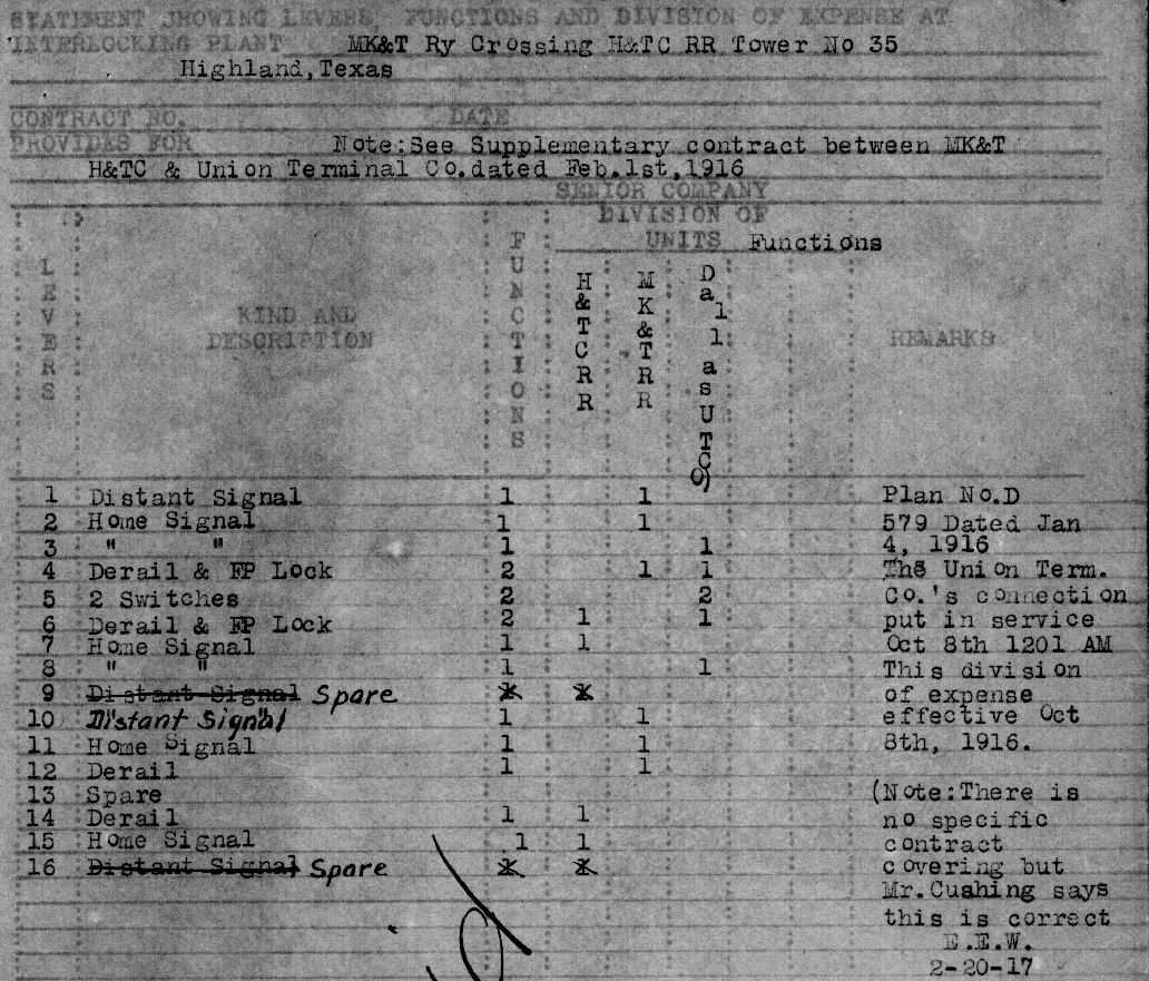 |
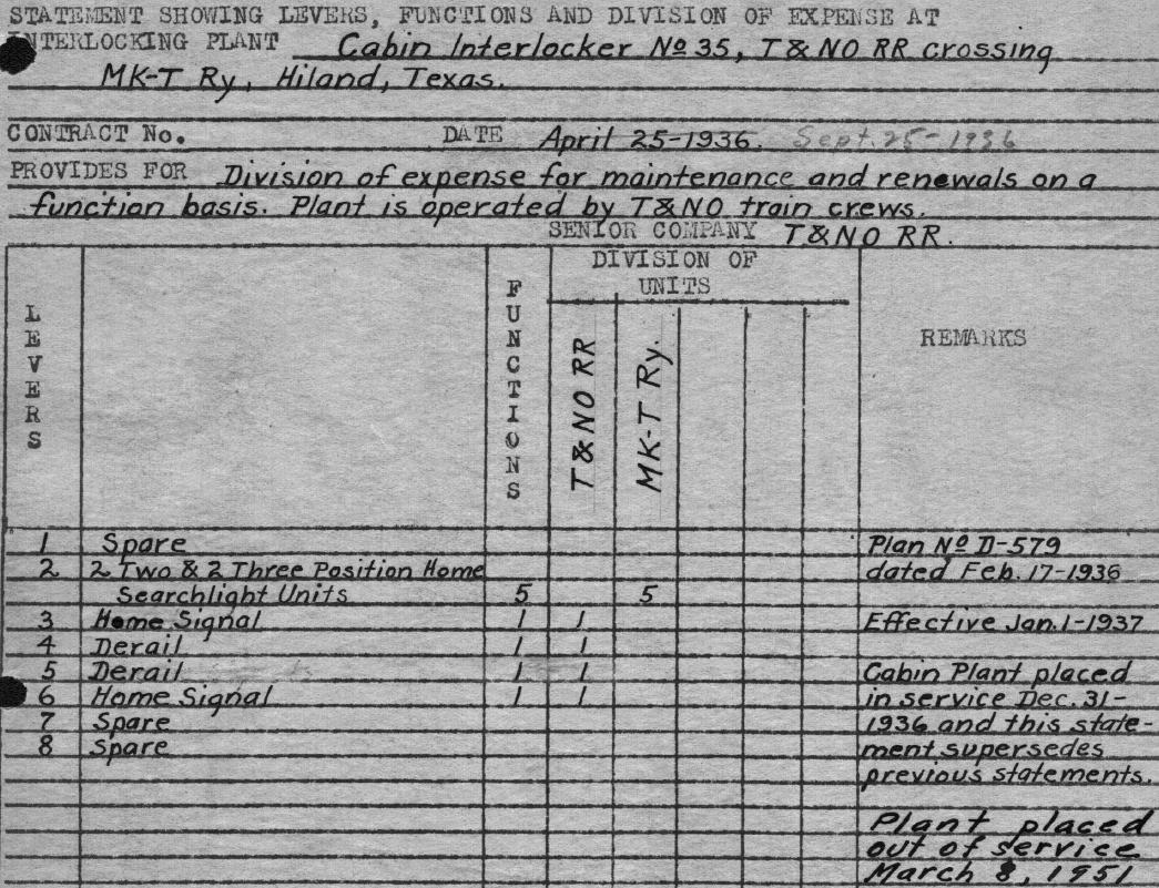
Left: For each
interlocking plant where SP shared recurring costs, its policy was to
fill out an internal "D-205" form titled "Statement Showing
Levers, Functions and Division of Expense at Interlocking Plant." This
one (Carl Codney Collection) is the upper portion of a D-205 revised in
1916 for Tower 35
at "Highland, Texas", named for the nearby town of Highland
Park incorporated in 1915 (eventually to be surrounded by Dallas.)
The is not the original D-205, and there may
have been revisions prior to 1916. The
form lists a design plan dated January 4, 1916 and notes
that the DUT connection was placed in service on October 8, 1916. The
bottom portion of the form has two notations ...
... and has two identical "Division of Expense" tables for Operations and Maintenance,
respectively, stating the O&M cost shares based on
the standard allocation formula.
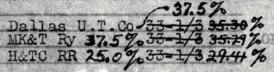
Initially, each railroad paid 33 1/3% because they each used six of
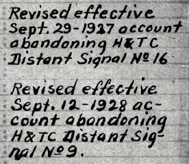
eighteen functions. H&TC eliminated a distant signal in 1927, changing the
percentages to 35.3%, 35.3% and 29.4%. Another distant signal dropped by H&TC
in 1928 revised the split to 37.5%, 37.5% and 25.0%. |
Although the above D-205 used Highland as
Tower 35's
location, two
superseding SP documents used Hiland, as did a summary list produced by SP.
RCT's published lists continued to use Oasis, but Hiland became the preferred name used by
railroaders. SP's 1925 Annual Report referenced it as Hiland Junction.
The distant signals
eliminated by the H&TC in 1927 and 1928 pertained to operational changes spurred by
the completion of the Dallas
Belt Line in 1926. The Belt Line bypassed downtown to the east and south, allowing the original H&TC main line to be
relegated to secondary status between Tower 118
(at Belt Jct. south of downtown) and
Gifford, where the bypass reconnected to SP's main line about five
miles north of Tower 35. The distant signal south of Tower 35 became unnecessary
because the tracks were only used for low speed switching operations; the
tower's home signal provided adequate warning. The distant signal north of Tower
35 wasn't needed because southbound passenger trains, which no longer crossed
the Katy, were governed by signals
near the tower, and they had to slow substantially anyway to take the
connecting track switch and curve. Southbound freight trains never reached the
Tower 35 distant signal
because they moved onto the Dallas Belt Line at
Gifford, which became the new main line as noted in SP Employee Timetables
(ETTs.) SP presumably rebuilt the switch at Gifford so that the
unswitched position routed the tracks onto the Belt Line.
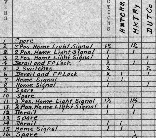
Right:
This image is extracted from SP's D-205 (Carl Codney Collection) for
Tower 35 that became effective October 9, 1930, presumably the next
revision after the above D-205. It shows assignments for seventeen
active functions managed by the interlocking plant, with four assigned
to the H&TC, seven assigned to the Katy and six assigned to DUT.
In both directions, the Katy had a "2 Pos. Home Light Signal" and a "3
Pos. Home Light Signal" (allocated as 1.5 functions) controlled by the
same lever (Lever 2 in one direction; Lever 11 in the other.) It is
unclear why this duplicative signaling was required. If the "2 Pos. Home
Light Signal" was actually a lighted semaphore, then it is one of
the two in
Barriger's photo. And if so, then the other semaphore in the photo would be the "2 Pos. Home Light Signal" assigned
to DUT on Lever 3. DUT had only one of these (presumably the Katy side
of the connecting track.) In DUT's opposite direction (the H&TC side) it had a "Home Signal" (Lever 8) as did the H&TC (Lever 7), both
presumably semaphores. The H&TC also had a second "Home Signal" (Lever
15) for its opposite direction. Note that there were no distant signals.
The H&TC tracks didn't need them, only carrying low speed switchers. The
Katy's August 24, 1933 ETT for the North Texas District notes Automatic
Block Signals (ABS) operating from Tower 106
downtown through the siding at Urban more than a mile north of Tower 35.
The interlocker was undoubtedly tied into this system to provide advance
warning in lieu of traditional distant signals.
Facing Point ("FP") Locks
improved switch safety and were generally required on switches that
handled passenger trains. The Katy had a "Derail and F P Lock" (Lever 4)
in one direction and a "Derail" in the other direction (Lever 12.) The
H&TC had an identical arrangment on Levers 6 and 14, respectively. The
DUT had a "Derail and F P Lock" in both directions controlled
respectively by the Katy's lever (Lever 4) and the H&TC's lever (Lever
6.) DUT also had two switches, both controlled by Lever 5. As the
connecting track was short, it was only useful if both switches were in the proper
position, hence the switches could be coupled to a single
function (i.e. "open the connector", "close the connector".) |
 |
In 1927, SP began to consolidate its various
Texas and Louisiana railroad companies into a single subsidiary by leasing them
to the T&NO (subsequently merging them into the T&NO corporation in 1934.)
Though T&NO trains now plied the H&TC routes, the tracks were still owned by the
H&TC (until 1934) so RCT continued listing H&TC at Tower 35 in its
subsequent annual reports. RCT did,
however, replace DUT with "UT", indicative of DUT's real name, the Union
Terminal Co. Unfortunately, this appears to have led to a mistake in RCT's list
dated December 31, 1929 wherein "UT" was replaced by "DTR&UD". This was a
mistake because the Dallas Terminal Railroad and Union Depot (DTR&UD) was not
the same railroad as UT / DUT. A year later, the mistake was corrected. After
that list was published on December 31, 1930, RCT stopped publishing an annual
comprehensive interlocker list though it would occasionally put information
about new interlockers in its annual report to the Legislature.
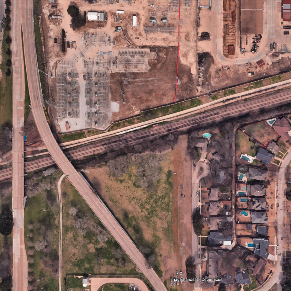
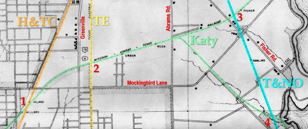
| Right:
This snippet from a late 1920s map of Dallas County shows the Tower 35
crossing at lower left (1). Hiland and Hilliard were
nearby sidings as were Urban, Rock and Fisher farther east on the Katy,
and Rawlins on the Dallas Belt Line.
The map illustrates that the Texas Electric (TE) Railway interurban line crossed
over the Katy (2) about 0.9 miles northeast of Tower 35.
One mile farther east, the Katy had a coal spur to serve a power plant
at the White Rock Lake Pump Station. Continuing east, the Katy (3)
passed over the Belt Line near the
community of Fisher. South of there, the Belt Line went over the Katy
coal spur (4) near the Pump Station at White Rock Lake. |
 |
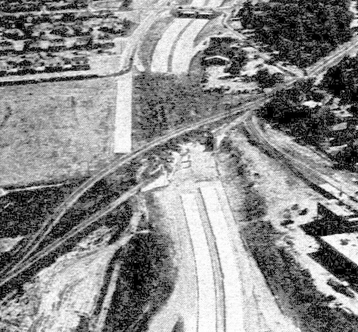
In October 1930, Sherman Mills Fairchild took 93 aerial
photographs of Dallas and surrounding areas commissioned by the City of Dallas.
Image snippets of some of them are reproduced below.
This valuable resource is available on-line
from SMU.


NOTE: These aerial images from 1930 and 2023 correspond to the numbered
locations on the annotated Dallas County map above. For all images, click to enlarge.
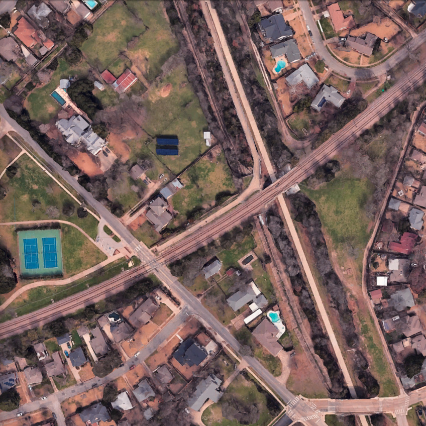
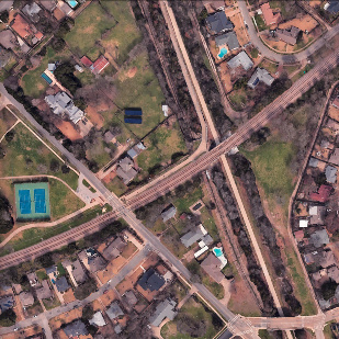
Above Left: (1) Tower
35 is visible in the acute south angle of the diamond casting a shadow to the
northeast. The "Air" in "Air Line Rd." is off the bottom of the image. The house
in the Barriger photo would be the one closest to where Air Line Rd. (now
Airline Rd.) crosses the tracks. Above Left
Center: (1) Today, the former H&TC main line right-of-way (ROW)
is occupied by Central Expressway, so named because "the Central" was the
common nickname for the H&TC. The Katy Trail
occupies the Katy ROW southwest of Airline Rd. Farther northeast, the Katy ROW
is now used by the Dallas Area Rapid Transit (DART) light rail Blue Line. The
Blue Line merges with DART's Red Line (built on / near the former H&TC ROW) to share a
track built in a tunnel beneath Central Expressway
south to downtown.
Above Right Center:
(2) The TE interurban line crossed over the Katy tracks almost a mile
northeast of Tower 35. There was an interchange track in the northwest quadrant
where the Katy and TE exchanged boxcars. The north / south road on the left side of the image is
Greenville Ave. (also known as Richardson Pike and Richardson Rd. in the early days.)
Above Right: (2) The TE ROW
north of the DART tracks is now used primarily to carry power and communications
utilities. The faint red line is a pipeline that was laid between June and October
2023, most likely a communications or power conduit. Greenville Ave. splits into
separate southbound and northbound roadways just north of the two bridges over the
DART tracks, one for each direction. South of the split, the northbound roadway, Matilda St.,
extends below the image and sits atop the TE ROW for just over two miles as it
parallels Greenville Ave. approaching downtown. On the north
side of the DART ROW, the
Univerity Crossing Trail / Ridgewood Trail is visible parallel to the
tracks.
Below Left: (3) Fisher was a
small rural community in 1930. The wide bright line is the ROW carrying SP's Belt Line
tracks,
reflecting newer style construction designed to carry heavy freight trains. The small line to
the left of the ROW is an alleyway which may have been for maintenance access. This section of the Belt Line
was built in a lengthy cut that allowed it to pass under the Katy tracks (which
preceded the Belt Line by forty years.) The roadway angling across the left side
of the image is Fisher Rd. The bridge casting a short shadow over the
Belt Line tracks at the bottom of the image was where Fisher Rd. crossed to the
opposite side of the Belt Line.
Below Left Center: (3) The DART Blue Line double-track has
replaced the Katy track. The Belt Line is now occupied by the
SoPac Trail. Fisher
Rd. remains mostly intact, but the bridge over the trail at the bottom of the
image has been renamed Rockaway Dr. Portions of the original alleyway beside the Belt Line are still
in place.
Below Right Center:
(4) Near White Rock Lake, the Belt Line was built on a large fill that went over
the Katy's spur to the Pump House and over Williamson Branch a hundred yards
farther south. In contrast to the cut used to the north at Fisher, the high fill
accounted for the significant decline in elevation approaching White Rock Creek
which was dammed to form the lake. The curved road in the lower right corner
was (and still is) W. Lawther Dr. Below
Right: (4) When the Katy coal spur was abandoned (in
the 1930s) SP
filled the underpass so that its Belt Line tracks rested entirely on fill
material and dirt, allowing the bridge over the Katy spur to be removed. Rather than
demolish its concrete
bridge abutments, SP simply covered them with dirt and gravel. The abandoned Katy
spur gradually became a lengthy green space, and the area at the south end of
the spur west of the Belt Line fill was converted to a neighborhood park,
Lakewood Park. White Rock Lake Park was on the other side of the fill, but
not directly accessible from Lakewood Park. In the early 2000s, long after this
section of the Belt Line had
been abandoned, the Katy spur ROW was excavated through the fill, uncovering the
concrete abutments. The City of Dallas eventually paved a short trail through
the fill to connect the two parks, reinforcing or replacing the concrete bridge
abutments. When the Belt Line ROW was converted to the SoPac Trail, a connection
was built on the east side of the fill to enable access to the new trail from either park. The connecting trail (visible in the image) is
lengthy due to the elevation gain required to reach the SoPac Trail atop the
fill. In this area, the trail is part of a 7-mile long segment that
occupies the former Belt Line
ROW as far northwest as Greenville Ave., departing the ROW about three quarters
of a mile shy of Gifford.
The H&TC tracks out of Dallas to the north ended at Denison
where the Katy and H&TC had cooperated on traffic exchange in the early years.
The Katy had owned two separate routes to Dallas from Denison since 1886 -- via
Denton on the T&P joint track and via Greenville -- thus the Katy had
quickly
begun moving freight between Denison and Dallas on its
own tracks rather than handing it over to the H&TC. The Katy eventually moved
its passenger trains to its own tracks
south of Denison once its track network had expanded in Texas to reach the major
cities in the south, particularly Houston (1893.) Overall, the
1908 Official Railway Guide shows the H&TC operating four daily round
trip trains between Dallas and Denison, none of them associated with single-train service to the Midwest (although
the H&TC did advertise Denison connections to St. Louis and Kansas City on
both the Katy and the Frisco.) One of the H&TC's daily trains was the
northbound Dallas
News, departing Dallas at 3:40 am to distribute newspapers to towns along
the route to Denison.
Interurban service between
Dallas and Sherman began in 1908 and connected to an interurban already
operating between Sherman and Denison. By 1911, the entire interurban
route between Denison and Dallas had been consolidated by the Texas Traction
Co. In 1917, Texas Traction merged with the Southern Traction Co. to form
the Texas Electric (TE) Railway. This impacted H&TC passenger service to / from
Denison, and by 1921, the Official Railway Guide listed the H&TC
with only two passenger trains daily to / from Denison. By 1932, SP was down to one round trip daily to
Denison, probably a motor car (and it was definitely a motor car by 1934.) SP's
final passenger trains to Denison were motor cars #15 and #16 on December 16,
1935.
About a year later, Tower 35 was replaced by a cabin interlocker on December
31, 1936. The Tower 35 building was abandoned, no longer manned because the cost
of operating the tower could not be justified by the nature of the traffic. SP
trains needed to cross the Katy occasionally to switch customers north of Tower
35, but otherwise there was little activity for operators largely due to the ABS
system in place by 1933. The new interlocker was installed in a trackside cabin
to be operated by SP train crews which always stopped at the crossing. A
crewmember would enter the cabin and set the signals to permit his train to
cross while warning any approaching Katy trains to prepare to stop. When the
crossing was complete, a crewmember would reset the levers to allow unrestricted
movements by Katy trains. DUT no longer paid a share of Tower 35 O&M costs
because the new interlocker did not control DUT's signals or switches (which
were likely connected to the ABS system for remote control.)
Right: This snippet from a subsequent revision
to SP's D-205 (Carl Codney Collection) shows that Tower 35 was converted
to a cabin interlocker on December 31, 1936. The Division of Expense
table (not shown) changed to 55.56% for the Katy and 44.44% for SP. Note
that all of the Katy's functions were controlled by Lever 2. The Katy
was allocated five functions even though it only had four signals (two
2-position and two 3-position home searchlights.) How these signals
operated in conjunction with the ABS system is undetermined, but Barriger's photo shows 3-position home searchlight
signals and semaphores at the crossing. The final notation on the document states
that the cabin was out of service on March 8, 1951.
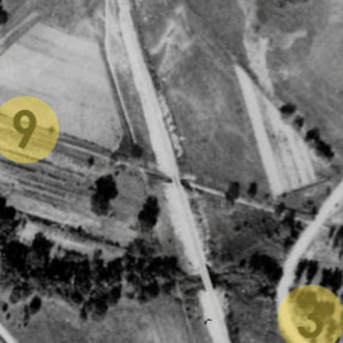
Below: This 1946 image
((c) HistoricAerials.com) shows that the Tower 35 structure remained in
place for at least nine years after the cabin
interlocker was installed at the start of 1937. The southwest side looks partially
collapsed; presumably the tower was eventually razed.
 |
 |
By 1937, it was clear that H&TC
tracks north from downtown would not survive much longer. The ROW would be
immensely valuable as a local transportation artery because Dallas' primary urban growth was to the north,
away from the swampy wetlands of the Trinity River that covered much of the land
south and west of downtown.
In 1947, the T&NO ROW between downtown and Hiland Jct. was officially
abandoned and soon became the construction path for Central Expressway. Plans
for the expressway motivated major businesses to begin moving north. In 1948,
the Dr. Pepper Company built a new headquarters and bottling plant a short
distance northeast of Tower 35 at the corner of Mockingbird Lane and Greenville
Ave. The facility lasted until 1997. In the early 1950s, Mrs. Baird's Bread Co.
began building a modern bakery on Mockingbird Lane immediately west of Central
Expressway, a few hundred yards northwest of where Tower 35 had stood. The bakery remained in operation until 2002.
 |
Construction of Central Expressway began downtown in
1949 and went north, reaching the vicinity of Tower 35 and Mockingbird Lane (a quarter
mile farther north) in January, 1950. North of Mockingbird, the freeway
construction remained atop the H&TC ROW for another mile to Milton Ave.
and then moved off of the ROW slightly west. This far north, open land was plentiful; there was
no need to occupy additional SP ROW. South of Milton and east of
the expressway, SP laid three quarters of a mile of track to reach a new
connection with the Katy for switching purposes (SP had stopped running
passenger trains on the Katy fifteen years earlier.) SP reused the name Hiland Jct. for the switch
which was
located about a half mile northeast of the former Tower
35 diamond. The Belt Line at Gifford was the
main line, so the tracks between Gifford and Hiland Jct.
became the Soumethun
Branch (as in Southern
Methodist University)
named for the first siding north of the Katy.
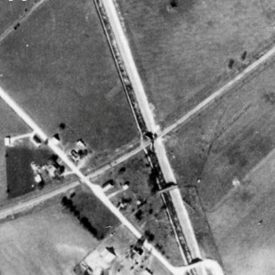
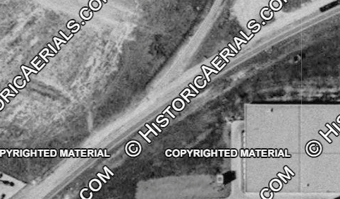
Left: Looking
south c.1952, a shoo fly track has been built to facilitate continued
rail operations while a new Katy bridge is built over Central
Expressway. The buildings in the lower right corner are the initial construction of Mrs. Baird's bakery, served by a Katy spur.
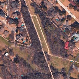
Below: These images
show Hiland Jct. in
1952 ((c) HistoricAerials.com) and 2025 (Google Maps) -- it's now the
connection between the DART Red and Blue Lines.
 |
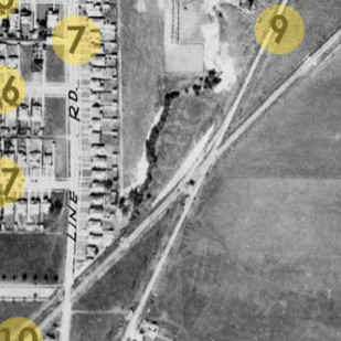
Soumethun was the name of a siding at least by
1915 when the name appeared in RCT's annual report. In those days, it would have
been associated with the spur track onto the SMU campus from the H&TC main line.
RCT's reference was in the context of authorized shipping rates, so it may have been the official
rail shipment address for SMU
deliveries, particularly coal (as shown on the 1926 track chart) and building
materials. When the spur was removed (date
undetermined), Soumethun became identified with a siding on the SP main
line. After SP laid tracks to the new Hiland Jct., the Soumethun name was applied
to the first siding north of the switch, and became the name of the entire
branch from Gifford.
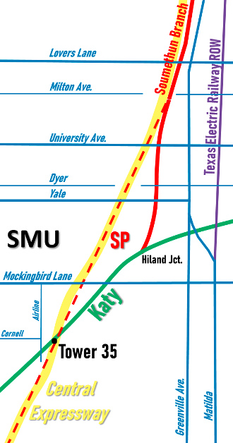
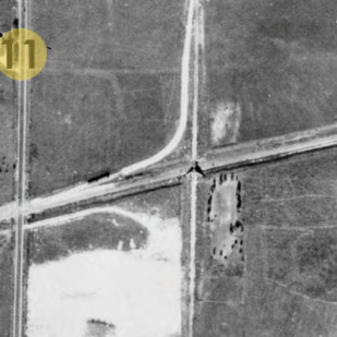
Above Left: This
graphic shows the route of Central Expressway (yellow highlight) in the
vicinity of Tower 35 and how its construction affected SP. The tracks (red dashes) on the H&TC ROW from
near
downtown all the way to Milton Ave. were straight. The expressway was
not straight, incorporating a few minor twists before turning slightly (but
permanently) away from the SP tracks at Milton. The tracks from Milton to
Gifford (about three miles north of Lovers Lane) became the northern part of the
Soumethun Branch. New tracks were built from Milton south to Hiland Jct. to
constitute the southern part of the Soumethun Branch.
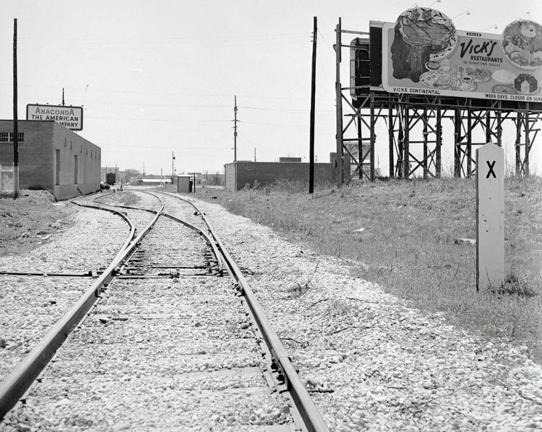
Above Right: This photo
labeled "Soumethun Siding" was taken by Everett L. DeGolyer, Jr. on April 4,
1958. His notes state "...about University Blvd and Central Expressway,
looking south."
Historic imagery shows the Soumethun Branch operational in 1952. Though
the aerial imagery lacks great clarity, Soumethun Siding appears to begin barely
north of University Blvd. on a slight curve, consistent with this photo, and it
ends at Dyer St.
Historic aerial imagery shows
that the new Hiland Jct. switch was gone by 1968. The SP tracks may have been removed as far north as Yale by
then; the clarity of the historic imagery is poor. In 1981, SP filed for permission
from the Interstate Commerce Commission to abandon 0.657 miles from "near
Oasis to ... near Soumethun, the end of the branch..." The south end of
Oasis siding was barely north of Lovers Lane, so it seems likely the
abandonment was between Lovers Lane and Yale, which approximates the same
distance along the ROW.
 |
These three photos are in the collection of the Dallas Public Library
documenting the construction of Central Expresway (hat tip,
dfwfreeways.com.)
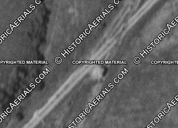
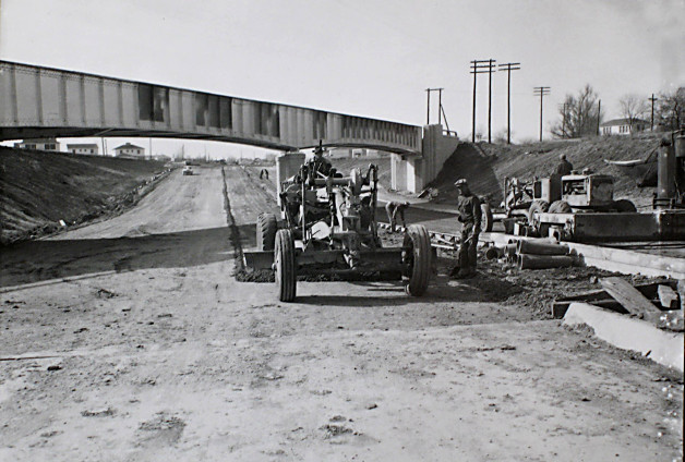
Above Left:
In this photo, the photographer was facing north at the Katy bridge.
Since the shoo fly has been removed, the Katy has (presumably) begun
regular operations over the bridge. The Library dated the photo as 1953;
the freeway opened to Mockingbird Lane on April 15, 1953.
The bridgework appears finished (it was delayed a year due to a steel
shortage) and the effort has shifted to the road surface and center
median. Geolocation of the Tower 35 crossing diamond places it in what
is now the center median of the expressway where a line extended due
east from Cornell Ave. would intersect.
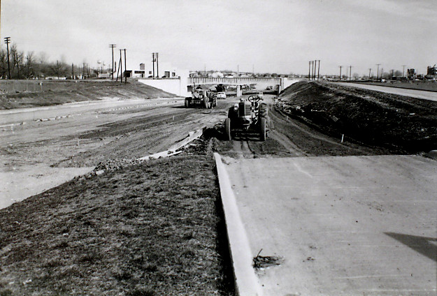
Above Right: This photo is dated by the
Library as 1950, but the bridge is finished and historic aerial image
shows the shoo fly remained in place in 1952. The view here is similar
to the scene above left but the photo was taken farther south, probably
early 1953. The buildings beyond the west approach to the bridge are
likely the beginnings of the aforementioned Mrs. Baird's Bread
bakery.
Left: Unaligned ties
that look unused suggest this
is construction, not demolition. Dated November, 1950 by the Library, it
is likely along the south end of the Soumethun Branch. The Library suggests Mockingbird
Lane which would imply Katy tracks (the Soumethun Branch did not reach
Mockingbird.) But the shoo fly photo above shows the bridge was built in
alignment with the existing tracks so that no construction would be
needed, certainly nothing like this. The Soumethun Branch at Yale is a
better guess. |
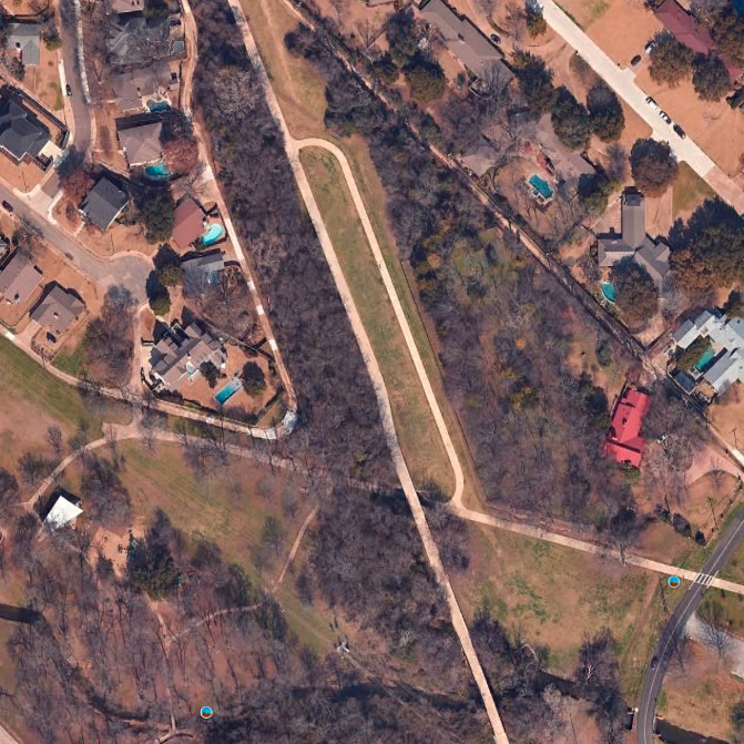
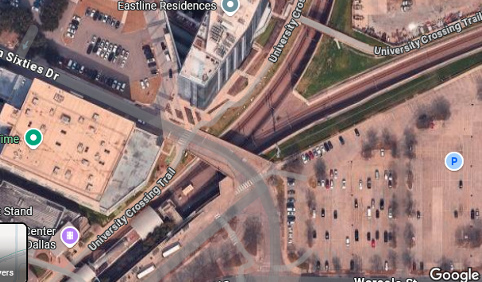
In the early 1990s, the Katy line through Dallas was
taken out of service by successor Union Pacific (UP) and was purchased by DART
for conversion to light rail use. DART's Blue Line used the ROW northeast from
Hiland Jct., the site of which became the connecting point for the Blue and Red
lines, reprising the Katy / SP connection from decades earlier. The SP ROW north
of Hiland Jct. was used for the DART Red Line. The new
Mockingbird Station light rail facility was built between Hiland Junction and
Mockingbird Lane. From Mockingbird Station, the Blue and Red Lines share a
tunnel beneath Central Expressway to downtown. The Katy ROW between downtown and
Tower 35 was converted to the Katy Trail.
Above Left: This view of the former Belt Line ROW, now the SoPac Trail,
was captured by Google Street View in August, 2022 from the Rockaway Dr. bridge.
The overpass ahead is the DART Blue Line at Fisher on the former Katy ROW. Above Right:
North of Mockingbird Lane, Matilda St. becomes Matilda Bridge as it curves west to pass over the DART Blue
Line and become the northbound lanes of Greenville Ave. As the curve begins, the
former TE ROW continues due north, occupied by power and utility lines. (Google
Street View, May, 2022) Below Left:
The Katy spur passed under the Belt Line near the White Rock Lake Pump House.
Today, both ROWs have been converted to trail use. The connecting trail at right
is long because of the elevation gain needed to reach the SoPac Trail atop the
Belt Line fill. (Google Street View, June, 2023)
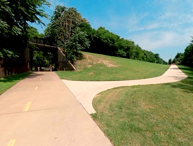
Below Right: This February, 2017 Google Street View of
the Airline Rd. grade crossing at the Katy Trail faces northeast
toward the site of Tower 35. Sound mitigation barriers for Central Expressway
are visible, and the house in Barriger's photo
is behind the trees and fence at left. The purpose of the silver cabin at left
is undetermined, but it has the style of cabins commonly used for railroad
signal and interlocking electronics. If so, it hasn't been used since the Katy
tracks were abandoned c.1991.