Texas Railroad History - Tower 78 - Garland
A Crossing of the Gulf, Colorado & Santa Fe Railway and the Missouri -
Kansas - Texas Railway

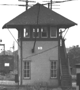
Above: John W. Barriger III
took this photo from the rear platform of his business car, his camera prompted by the sudden appearance of Tower 78. Barriger's
train was southbound on the Missouri - Kansas - Texas (MKT) Railway toward
downtown Dallas, and his view at this point is east-northeast.
He has just passed over the diamond at the intersection of the Gulf, Colorado &
Santa Fe Railway tracks in Garland, a crossing controlled by Tower 78. The date
of this trip is unknown, but mid-1930s is a reasonable guess. The road crossing
in the foreground is most likely 4th St. (formerly Forrest, before Garland
renumbered its downtown streets), which no longer crosses the tracks. Roughly 90
years later, the diamond remains intact, though neither of the original
railroads is involved. The area has experienced vast change from urban growth
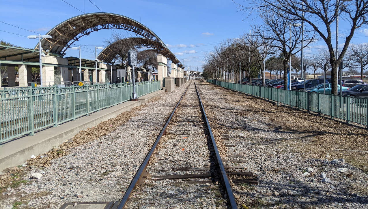
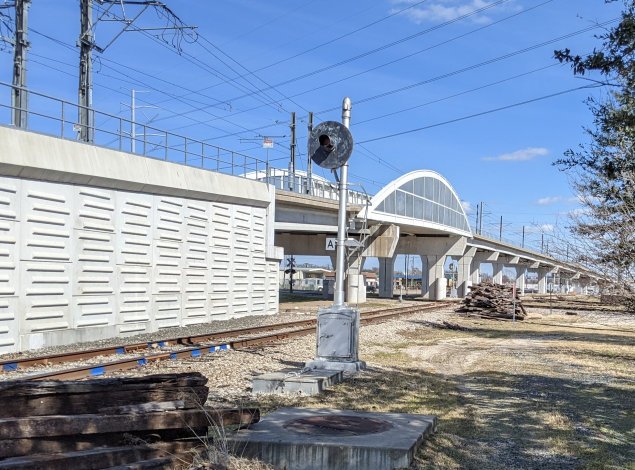
and shared use of the MKT right-of-way by the Dallas Area Rapid Transit light rail system. A corresponding image from 4th St. is no longer
feasible, so the view from 5th St. (below)
adjacent to the Garland light rail station will have to suffice. The bridge in
the distance belies the curve of the track to the right, parallel to the bridge,
the same curve that begins at Tower 78 in Barriger's photo. (Jim King photo, 15 Feb 2022)
A few moments after John W. Barriger III took his photo
of Tower 78, his business car passed the Missouri - Kansas - Texas (MKT, "Katy")
Railroad depot in Garland. If there were any oldtimers sitting around the depot
that day who could remember the area from fifty years earlier, they might have
recalled watching trains stop at the Duck Creek station as they sat in approximately the
same spot. That would have been back when the railroad first reached the
community, named for the creek that still flows through
town. It was officially the Dallas & Greenville (D&G) Railway that built through
the area in 1886, but the investors were associated with the Katy, which soon
acquired the new line running from Greenville to
Dallas. The Katy had crossed the Red
River into Denison in 1872 and several years later had begun to sponsor branch
lines that they would acquire soon after construction was complete. This included
a southeast branch from Denison to Greenville that was later extended to
Mineola, as well
as the
branch from Greenville to Dallas that passed near Duck Creek in far northeast
Dallas County. The two branches combined to form the Katy's main line between
Dallas and the Red River bridge, hosting for decades the various Katy passenger
trains bound for St. Louis and the upper midwest. In 1880, the Katy had come
under the control of railroad mogul Jay Gould
who had leased it to another of his properties, the Missouri Pacific (MP)
Railroad.
So...the track to Duck Creek was built by the D&G, funded by investors
affiliated with the Katy, and operated by MP. In the newspapers and among the
local population, it was strictly an MP show; they got all of the credit (and
blame) for construction and operation.
If the hypothetical oldtimers who watched Barriger's train could remember the
Duck Creek station of 1887, they would have known that it was actually in "new"
Duck Creek. The business district of "old" Duck Creek was about a mile southwest
of the depot. The locals quickly bought
into the new townsite - being near the depot was certainly a benefit - but it
was mostly a preemptive move. Had Duck Creek not embraced the new depot and relocated
to its vicinity, MP could have effectively killed Duck Creek by choosing a different name
for their station, perhaps one influenced by neighboring landowners or
outside investors. Or...a thought so outrageous it could not be said in
public...MP might have named it Embree.
Embree was a community on the Gulf, Colorado & Santa Fe
(GC&SF, "Santa Fe") Railway near Duck Creek. Santa Fe was building a line from Dallas to Paris
and the construction through this area occurred only a few months before MP's
tracks reached Duck Creek from Greenville. Santa
Fe's line northeast to Paris, via Farmersville, Celeste and
Wolfe City, was a planned extension of their line from Cleburne to
Dallas, a set of tracks they had acquired a few years earlier from the Chicago, Texas & Mexican Central
(CT&MC) Railway. Buying the CT&MC gave Santa Fe its first service into Dallas, but equally
important was the longer term objective to extend the line to Paris. The St. Louis San Francisco Railway
was building a route from Missouri to Paris via Ft. Smith and eastern Oklahoma
that would bridge the Red River (in 1888) fifteen miles north of Paris. This
route created a shorter trip to
St. Louis than the existing alternatives that crossed the Red River near Denison
or Texarkana.
The Galveston Daily News of July 17, 1886
reported on the progress of both railroads: "The Greenville and Dallas road
is graded for a distance of thirty miles. Track-laying will begin about August
1, and it is expected that the cars will be running from Greenville to Caddo
Mills by the middle of August and to Rockwall by the 1st of September. A train
of twenty cars of construction material was run out to Embree, on the Santa Fe
extension, yesterday. Speaking of Embree, it is reported that the Missouri
Pacific has located its depot near the flouring mill, and that the town will not
be removed. ... Track-laying on the Santa Fe extension was completed to the
sixteenth mile-post last night. Two switches have been put down, one at
Reinhardt and the other at Embree." When MP's construction forces
reached the vicinity of Duck Creek later in 1886, they had to cross Santa Fe's
tracks a short distance north of Embree, the location that eventually hosted
Tower 78.
The Santa Fe ROW passed a mile
east of the "old" Duck Creek business district on land owned by Dr. K. H. Embree,
who made a deal with Col. W. D. Wylie, Santa Fe's right-of-way agent. In
exchange for a free ROW and land for a depot, Santa Fe would name
the town Embree (perhaps planting a seed in Col. Wylie's mind; the next town north of Embree
became Wylie.) Dr. Embree expected a majority of Duck Creek residents to
relocate the short distance east, especially since MP's plans for
entering Dallas County were not yet finalized. Santa Fe's tracks were
coming through Embree; why not take the sure thing? Dr. Embree was a
well known local physician who, besides landowner and townsite
organizer, had held a very important part-time job: Postmaster for Duck Creek.
Per the
above report in the
Galveston Daily News, MP had decided that "...the
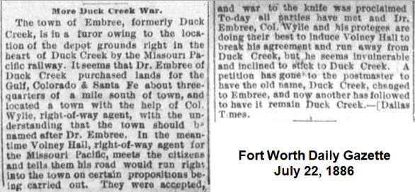
town will not be removed." Santa Fe tried to convince MP to forego naming their depot Duck Creek. Embree
was only a quarter mile from MP's planned depot site, but MP stuck to an
agreement they had made with Duck Creek (below,
Fort Worth Daily Gazette, July 22,
1886.) The Duck Creekers were also convinced that relocating their
businesses to the "new" Duck Creek would prevent their
post office from being moved to Embree.
 |
 Above:
historic map provided by the City of Garland Above:
historic map provided by the City of Garland |
Post Office officials made it clear that they would not
sanction two post offices less than a mile apart. Yet, it was obvious that the
existing post office at "old" Duck Creek could not remain in place as businesses
and residents were relocating to both Embree and "new" Duck Creek. A
fire in the "old" Duck Creek business district in January, 1887 may have been the deciding factor. The fire wiped out numerous businesses and
helped spur additional relocations to Embree. The Fort
Worth Daily Gazette of January 8, 1887 reported on the fire, noting that "A
rival town to Duck Creek called Embree was recently established a mile
away...which hurt the business prospects of Duck Creek, and the people had set
the coming week as the time to put the houses on wheels and move to Embree."
Embree had a head start on "new" Duck Creek, and the fire likely helped Dr. Embree convince
postal officials to move the post office to Embree.
The relocation occurred on February 1, 1887, and Duck Creek citizens did not
take it well. Their post office had dated back to 1854, and although it had
closed after the Civil War, it had reopened and operated continuously since
1877.
Galveston Daily News, August
24, 1887
Galveston Daily News, November
16, 1887
|
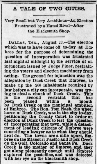
Top Left: Having obtained a post office at the
expense of Duck Creek, Embree sought to consolidate their victory by
incorporating their town. This required a vote by the residents within the
proposed boundaries of Embree. The Galveston
Daily News of August 24, 1887 reported on the latest skirmish, an injunction issued by
District Judge Piner to prevent Embree from holding the election. On August
27th, Embree retaliated by obtaining an injunction to prevent Duck
Creek's incorporation election that had been scheduled for September 17th.
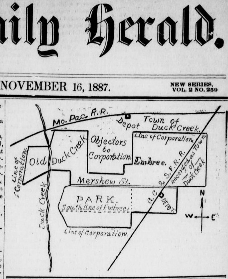
Top Right:
This map of the postal battlefield in northeast Dallas County was
published on the front page of the Dallas
Daily Herald of November 16, 1887 along with an article
explaining the current status of the conflict. Embree had appealed Judge
Piner's ruling and won, causing the injunction to be dissolved. But then Duck
Creek appealed that ruling and filed a supersedeas bond which had the
legal effect of staying the appellate court's dissolution of the
injunction pending action by the Texas Supreme Court. Believing the
injunction was dissolved, Embree quickly held their election on
November 12, 1887 (and incorporation passed.) Duck Creek's lawyers
responded by presenting affidavits against Embree officials in district
court, claiming they were in contempt of Judge Piner's injunction. District Judge
Aldridge took over the case and immediately issued arrest warrants for six of Embree's election officials. The following week, he
discharged the arrestees, ruling that Judge Piner had no jurisdiction to
enter the original injunction, hence it was null and void, and could not be violated.
Bottom Left: In an
article about the arrest warrants issued for Embree election officials,
the Galveston
Daily News of November 16, 1887 mentions that a potential
compromise plan was in the works.
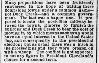
Below and Below Right: ...but there was a last
minute hitch!
 |
Galveston
Daily News, January 10, 1888 |
By the end of November, 1887, the war was at a
stalemate, but only Embree had a post office.
In October, Congressman Joseph Abbott, the U. S. Representative for Texas' Sixth District,
had been asked to look into the issue, and he had stopped at Duck Creek for a meeting with local leaders
as he was on his way to Washington, D. C. Through Abbott's efforts in Washington, Post Office officials
approved an agreement to have the Embree Post Office
moved to a new location halfway between the two railroad depots (one source says
the agreement was included in a law passed by Congress.)
The new
post office was required to be within "80 rods" -- one quarter mile -- of both depots,
and it stated that the new
post office would be known as Garland, in honor of Augustus Garland, the
U. S. Attorney General at the time. The post office was
relocated (notwithstanding a last minute hitch regarding its precise location), and on April 21, 1891, the town of Garland was
incorporated, encompassing all of the area within the outer boundaries that had been proposed for
incorporation of Embree and Duck
Creek. The name Embree eventually disappeared from the local vernacular. [Editor's Note: I worked in Garland
for 42 years and never heard the name.] The name Duck Creek, on
the other hand, has remained in common use, but only because various businesses, residential areas and apartments have adopted it into their identity due
to their proximity to the creek that still flows through Garland. The city has
long since expanded its limits, not only annexing the land where "old" Duck Creek
sat, but
pushing its borders to reach the adjacent towns in Dallas County to the
south and west, and Collin County to the north, raising its population
to nearly a quarter million by 2020.
The GC&SF line from Dallas
through Embree to Paris had been built as part of an 1886 agreement wherein the
much larger Atchison, Topeka & Santa Fe (AT&SF) Railway would acquire the GC&SF
as a wholly owned subsidiary if three GC&SF construction projects were completed
within a year. In addition to the Paris line, the others were a main line
extension north from Ft. Worth to Purcell, Oklahoma and a branch line from
Cleburne to Weatherford. The acquisition proceeded as planned in 1887 and the
GC&SF began operating as a wholly-owned subsidiary of the AT&SF. The GC&SF
operated under its own name until August 1, 1965 when it became fully merged
into the AT&SF. In 1995, the AT&SF merged with Burlington Northern to create
Burlington Northern Santa Fe (BNSF.)
In contrast to Santa Fe, the Katy's situation went in the
opposite direction. New Texas Attorney General (and future Governor)
James
S. Hogg sued the Katy in 1887 for non-compliance with Texas' railroad
ownership and service laws, a factor in Gould losing control of the Katy and the MP lease
being dissolved. In 1890, the Texas Supreme Court affirmed a lower court's
ruling
against the Katy. In response, the Katy's Texas holdings were consolidated in
1891 under a new state law that chartered a new railroad, the Missouri, Kansas and Texas
Railway Co. of Texas, as a wholly-owned subsidiary of the larger Katy
railroad. The new company's
headquarters was at Denison, an in-state location required for compliance with
Texas' railroad ownership law. After 1891, the
parent Katy railroad remained financially stable until 1915 when the entire company went into
receivership. Coming out of bankruptcy in 1923, the Texas lines were reorganized
as the Missouri - Kansas - Texas Railroad Co. of Texas (hence, both
MK&T and M-K-T have been used as abbreviations for the
Katy.) About 100 years after the MP lease
was dissolved, the Katy once again came under the control of MP in 1988. By
then, MP was owned by Union Pacific (UP) but operated as a subsidiary under the
MP name. When UP bought the Katy, its infrastructure and operations were then
fully integrated into MP, which subsequently became fully merged into UP in 1997.
On April 5, 1909, the Railroad Commission of Texas (RCT) authorized Tower 78 to
commence operations controlling the Katy/Santa Fe crossing in Garland with a
17-function electrical interlocker. Unlike many interlockers managed by RCT, the
configuration of Tower 78 appears to have remained static - the function count
never changed - at
least through December 31, 1930, the date of RCT's last publication that
detailed function counts and interlocker types for all active interlockers in
Texas. Twelve of the 17 functions would have been used for home signals, distant
signals and derails in each direction. The remaining five functions most likely
pertained to siding and exchange tracks located near the diamond. Because the
crossing in Garland existed prior to 1901, state law required the two railroads
to split the capital expense of building the tower. Typically, one railroad
would take the lead for designing and
building the tower and acquiring the interlocking plant. The railroads
would then settle the construction funding when the tower was commissioned. At that point,
one railroad (typically, but not always, the one that built the tower) would
take responsibility for maintaining the building and the interlocking plant,
signals and derails, and for staffing the tower's operations. They would bill
the other railroad for the assigned share of recurring labor and materials expenses on a "weighted function" basis.
(Without knowing all of the interlocker function assignments, the expense sharing
for Tower 78 cannot be determined.) RCT information published in 1916
shows that Santa Fe was responsible for operating the tower, so it is a
reasonable guess that they maintained it and most likely had taken the lead on
building it.
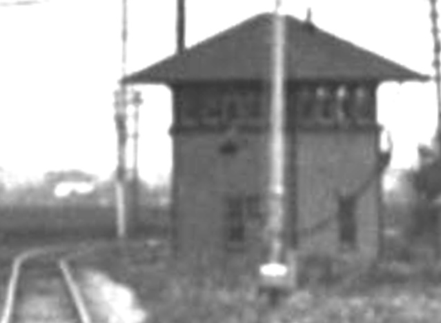 |
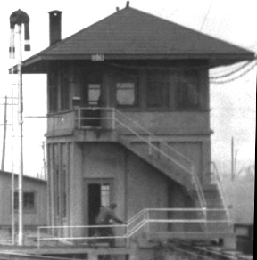
Magnification of Barriger's
photo of Tower 78 (left) shows a structure that resembles typical
Santa Fe tower designs, such as Tower 24 in Temple (near right), a photo
that Barriger also took. In contrast, Barriger's photo of a typical Katy
tower, Tower 53 in Fort Worth (far
right), shows that the Katy often used concrete
construction for its tower designs (but not exclusively - see
Tower 69 and Tower
58 where vertical planks are used.)
More typical examples
include the Katy's Tower 64 in Greenville,
Santa Fe's Tower 23 in Milano, the Katy's
Tower 93 in Denison, and Santa Fe's
Tower 52 in Cameron. |
 |
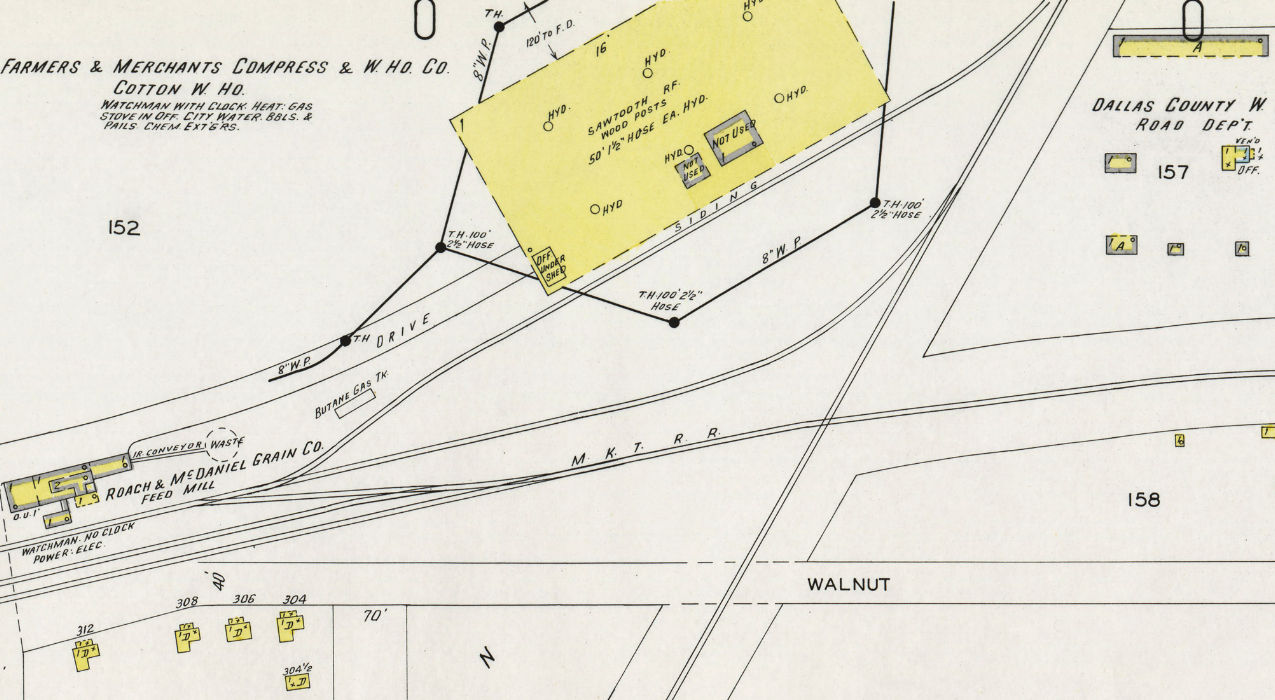
Above: The only
Sanborn Fire Insurance map of Garland that shows the crossing is Sheet 4 of the
1947 map set. By this date, Tower 78 had been removed, replaced by an automatic
interlocker. According to Katy employee timetables published December 6, 1942
and April 11, 1943, the Garland interlocker became automatic at some point
between those dates. Presumably, Tower 78 was removed at that time; the fate of
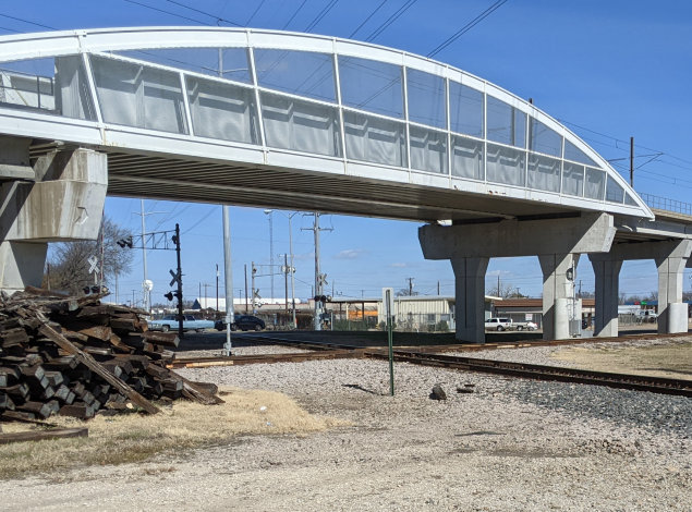
the structure is unknown. Below: These
two images show the crossing at Tower 78 as of February, 2022. The Dallas Area
Rapid Transit (DART) light rail bridge over the former Santa Fe tracks dominates
the view, but the crossing remains intact, now used by Kansas City Southern on
the former Santa Fe line and the Dallas, Garland & Northeastern
Railroad on the former Katy tracks. The view in both photos is from the
southwest quadrant, at or near where the tower was located, facing generally
northeast. The letter A on the home signal post indicates Automatic
interlocking. (Jim King photos)
In 1939, Kansas City Southern (KCS) acquired the Louisiana & Arkansas Railway
which operated a main east/west line between Shreveport, Louisiana and McKinney,
Texas that passed
through Greenville. At Farmersville, west of Greenville, the L&A was using
trackage rights to reach Dallas on
Santa Fe's line that passed through Garland. KCS inherited those rights, and a
year later, abandoned the L&A
tracks between Farmersville and McKinney. In the early 1990s, Santa Fe sold the tracks
between Dallas and Farmersville to KCS and sold the tracks from Farmersville to
Paris to the Chaparral Railroad (the Chaparral segment was abandoned in 1995.)
The end result was a KCS main line out of Dallas that makes a right turn at
Farmersville to proceed due east to Greenville, Shreveport and beyond.
After MP's acquisition of the Katy in 1988, various Katy and MP routes were
sold off, abandoned or leased to other railroads to eliminate unnecessary lines.
The Katy tracks between Dallas and Greenville were acquired by the Dallas,
Garland & Northeastern (DGNO) which began operating the line between Garland and
Greenville. DART had acquired the rights to use the Katy ROW for its light rail
system between Tower 35 (which had long been
obliterated by North Central Expressway in Dallas) and the town of Rowlett east
of Garland. West of Tower 78, DGNO was allowed to continue operating the Katy
tracks to reach industrial customers, but only as far west as Interstate 635,
where the Katy bridge over the freeway was rebuilt to support light rail only.
DGNO provides switching services in various parts of Dallas, and has rights to
use KCS' tracks from Garland to downtown Dallas using a connecting track in the
southeast quadrant of the Tower 78 crossing.

Above Left: The
last Santa Fe depot in Garland was a modest brick building along the east side
of the tracks at the Fifth St. grade crossing. It is now used as an office by
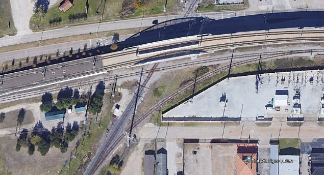
KCS. (Jim King photo, Feb. 2022) Above Right:
This Google Earth satellite image of the Tower 78 crossing is from November,
2017. The southeast quadrant connecting track allows DGNO to reach downtown
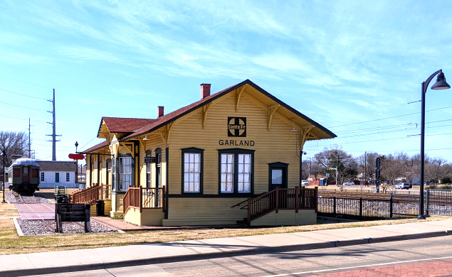
Dallas using KCS' tracks. Below Left:
If the hypothetical oldtimers that watched Barriger's train pass by were around
today, they would be very confused by this image. The depot in which they would
have been sitting was also trackside, about a hundred yards east of this
location, but it was the Katy depot, not the 1901-vintage Santa Fe depot! Santa Fe's depot sat near its original
location on the east side of downtown for decades after it was taken out of
service. In 2014, the City of Garland relocated it to
a new spot close to where the Katy depot had stood for decades. The building currently houses the Garland Landmark Museum. The tracks in the background are two DART
light rail lines and DGNO's single track, closest to the depot. The photo was
taken from N. 6th St. (Jim
King photo, Feb. 2022) Below Right:
The Garland Landmark Society provides this undated photo of the Katy depot in
Garland. This was the last Katy depot to serve Garland, undoubtedly preceded by
one or more early vintage buildings. This building survived until 2013 and had
been used by DGNO as an office.

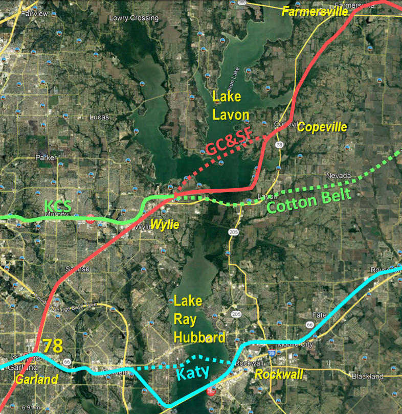 |
Left: The Santa Fe and
Katy routes immediately northeast of Garland each required line relocations due to the construction of large reservoirs to serve the
growing water needs of metropolitan Dallas. Lake Ray Hubbard's
construction between 1964 and 1969 caused relocation of the Katy's tracks
southwest of Rockwall. This included having the railroad share one of the
two Interstate 30 bridges over the lake. In 1948, Lake Lavon's construction commenced, requiring
realignment of Santa Fe's tracks between Wylie and Copeville. A St. Louis Southwestern ("Cotton Belt") line between Greenville and
Ft. Worth passed through this area and crossed the Santa Fe near Wylie
(uncontrolled, at grade), but was not directly affected by the construction of Lake Lavon. However, upstream flooding
in 1990 necessitated heavy releases of water through the Lake Lavon
dam, seriously damaging the Cotton Belt bridge and tracks below the dam. Rather
than rebuild it, Southern Pacific, owner of the Cotton Belt, elected to abandon
23 miles of track between Wylie and the western outskirts of Greenville. West
of Wylie, the Cotton Belt tracks remained in place but were taken out of service
and the right-of-way was sold to DART for future transit use. After procuring
Santa Fe's line through Garland and Wylie, KCS reached an agreement with DART
in 1995 for
trackage rights on the former Cotton Belt line and reactivated service west of Wylie.
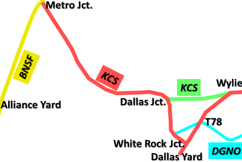
Farther west, it connects to another KCS branch line acquired from Santa
Fe. The result is a shortcut across southern
Collin County that allows KCS trains coming out of BNSF's Alliance Yard
north of Fort Worth to bypass Dallas and proceed straight to Wylie (below.)
 |