Texas Railroad History - Tower 82 - San Angelo
A Crossing of the Gulf, Colorado & Santa Fe Railway and the
Kansas City, Mexico & Orient Railroad
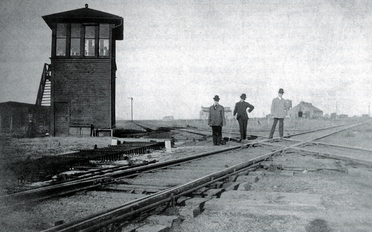
Above: This undated photo of Tower 82 from the Robert E.
Pounds collection appears in the book The Orient,
by Robert E. Pounds, John B. McCall and John R. Signor, published in 2011 by the
Santa Fe Railway Historical & Modeling Society, Midwest City, OK (hat tip, Todd
Minsk.) The tower was located southeast of the diamond, and the camera is facing
generally in the direction of San Angelo. Sources differ on the precise
timeframe of construction, but it was sometime around 1910, and this photo could
easily be of railroad or construction management viewing the newly built tower.
 |
Left:
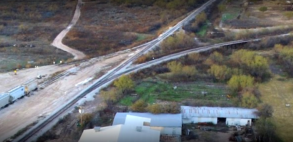
This north-facing drone image shows the former crossing
of the Gulf, Colorado & Santa Fe (GC&SF) Railway and the Kansas City, Mexico &
Orient (KCM&O) Railway on the north side of San Angelo. The crossing was
interlocked as Tower 82 in the numbering system of the Railroad Commission of
Texas (RCT). There is no longer a diamond here; the north / south former KCM&O tracks
are continuous while the former GC&SF rails connect into it from the northeast and
southwest, but no longer cross.
The tracks to the north reach a yard and
a rail park, but are abandoned beyond E. 50th St., just over two miles from the junction. To the southwest,
the tracks end in a half mile, serving a business on the south side of Culwell
St. The other two directions from the crossing extend beyond San Angelo to
connect to the national rail network. To the northeast, the line connects to the
Burlington Northern Santa Fe main line at San Angelo Junction, five miles
southeast of Coleman. The line south turns southwest to Fort Stockton,
continuing to Alpine where it connects to Union Pacific's Sunset Route. (photo by Miguel O, 2017) |
The Gulf, Colorado & Santa Fe (GC&SF) Railway started
construction in 1875 with a long term plan to reach New Mexico and Colorado.
After various financial issues were resolved with a brief bankruptcy in 1879,
their main line construction from Galveston reached Lampasas
in 1882. The end of track remained there for a couple of years while the company
did construction work elsewhere, mainly
branches off the main line into east Texas and Houston.
In 1885, construction resumed northwest from Lampasas, completing 71 miles to Brownwood in
December. The question on the minds of west Texans was...where precisely was this
northwestern main line headed?
The Taylor County News, June 5, 1885
The Taylor County News, June 19, 1885 |
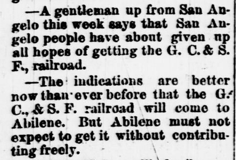
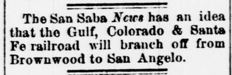
The Taylor County News kept close
tabs on the GC&SF's northwest progress virtually every week in the
spring and summer of 1885, regurgitating rumors fed by passing travelers
claiming to have inside information about the GC&SF's plans. As an
Abilene weekly, every Friday's newspaper reflected bona fide hometown
optimism that the main line would be coming to
Abilene.
Left:
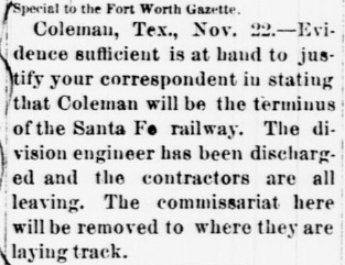
The Taylor County News of November
27, 1885, quotes a Fort Worth Gazette
report that the main line has terminated at Coleman, and that the
"commissariat" was being redeployed. The location "where they are laying
track" was a westward line that branched off the main track near
Coleman.
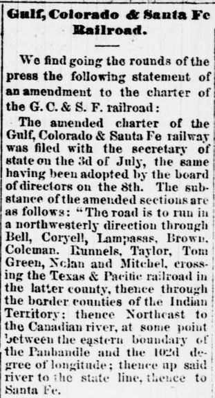
GC&SF historian William Osborn describes the charter amendment
that was filed by the GC&SF early in the summer of 1885.
...there was debate within the company regarding the best destination
for its westward terminus...[T]he charter was amended to provide for a
change of route west of Temple, routing through the counties of Bell,
Coryell, Lampasas, Brown, Coleman, Runnels, Taylor, Tom Green, Nolan and
Mitchell, forming a junction there with the Texas & Pacific Railway. Jay
Gould�s Texas & Pacific line between Fort Worth and El Paso had been
completed in 1881... |
The Taylor County News, June 25, 1885 |
The GC&SF amended their charter in the summer of 1885,
and it included a list of counties to which they expected to build. By July,
1885, the GC&SF had already built through Bell County (Temple, Belton, Killeen),
Coryell County (Copperas Cove) and Lampasas County (Lampasas.) From Lampasas,
they had continued into Brown County at Goldthwaite, a town that would become
the seat of Mills County when that county
was carved out of surrounding neighbors two years later. From Goldthwaite, tracks
would reach Brownwood in December, 1885. Beyond Brownwood, the details were
vague with six additional counties listed: Coleman (Coleman), Runnels
(Runnels City), Taylor (Abilene), Tom Green (San Angelo), Nolan (Sweetwater) and
Mitchell (Colorado City.) Three of these, Taylor, Nolan and Mitchell, were
east / west neighbors through which the Texas & Pacific (T&P) Railway passed, but
the T&P was about fifty miles north of Brownwood. The
charter amendment specifically cited Mitchell County as the crossing point of
the T&P, so listing all three counties left people wondering if the GC&SF
planned to parallel the T&P between Abilene and Colorado City, an idea that made
no sense. The
other three counties were east / west neighbors generally aligned with, and west
of, Brown County. Coleman County was due west of Brownwood and undoubtedly would
be next for construction. From the town of Coleman, there was an obvious route
north to Abilene in Taylor County and there was a feasible alternative through
Runnels County into Nolan and Mitchell counties. Tom Green County (San Angelo) was
the apparent outlier sitting mostly southwest of Runnels County. There was
literally no sane way to build to all of these counties without a branch line
somewhere. If a branch was being considered, the details were unknown,
or at least undisclosed.
There would indeed be a branch line that would
go west toward San Angelo. After it was
built, it was treated as the main line for more than two decades because the
"real" main line to the northwest had stopped at Coleman, five miles
beyond the branch point for San Angelo. With the future main
line merely a 5-mile stub to Coleman, the connection of the main and branch
lines became known as Coleman Junction. Santa Fe subsidiary Pecos &
Northern Texas (P&NT) finally completed the northwest main line between Coleman
and Slaton in 1911.
 |
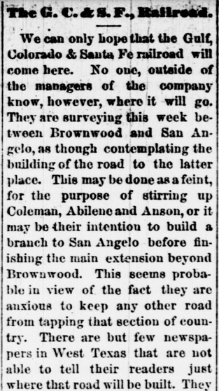
The Taylor County News of July 24, 1885 (left
and right) reported on the details of the amended
charter filed by the GC&SF, charitably calling it "the most
incomprehensible muddle of all." Earlier (below
left, July 3, 1885) the same newspaper had
hypothesized that if the GC&SF built to San Angelo, it would only be a
branch line, because, of course, the main line would still come to
Abilene! They were half right. The semi-official bad news soon arrived (below
right, The Taylor County News,
October 30, 1885); the
extension toward Abilene would stop a few miles beyond Coleman, at least for
a few years (and it would actually end within the town of
Coleman, not beyond it.)
Construction northwest of Coleman didn't resume until 1911 when the P&NT
built 183 miles to Slaton. There it connected with Santa Fe's network to
New Mexico and California. Eventually, the tracks through Coleman came
to be considered the main line, so Coleman Junction was renamed "San
Angelo Junction". The P&NT tracks passed no closer than eleven miles
from downtown Abilene, going through nearby Buffalo Gap instead. (Editor's Note: It is
not true that building through Buffalo Gap was intended to capitalize on passengers'
desire
to enjoy
the world's
greatest Jalapeno Cheesecake! ...hat tip, Jimmy Barlow. The purveyor,
Perini Ranch Steakhouse,
was not established until 1983, but your Editor can confirm that this
would have provided a legitimate reason to build through Buffalo Gap.)
 |
 |
 |
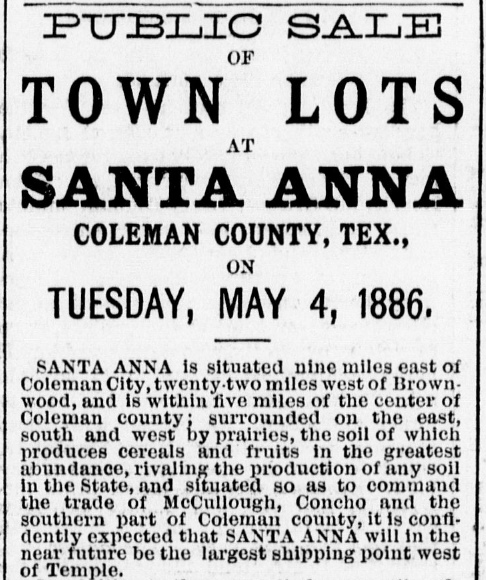
Left: The
Galveston Daily News of January 25, 1886 quotes a story from
the Abilene Reporter that
again was half right. There was indeed a branch line being planned
toward Runnels and San Angelo. The branch point off the main line would
be Coleman Junction five miles east of Coleman. The location "nine miles east"
of Coleman was where the new town of Santa Anna would be founded, as advertised in the Galveston Daily News of
April 19, 1886 (right). The optimism of the
Abilene Reporter ("This almost
insures Abilene the main line...") would not be rewarded, however,
despite their self-congratulation. When the extension was actually
built, it bypassed Abilene eleven miles southwest and crossed the T&P a few miles east of
Sweetwater in Nolan County, 33 miles west
of Abilene. The crossing was 34 miles east of Colorado City, seat of Mitchell
County where the junction had been projected in the GC&SF's amended charter.
Below:
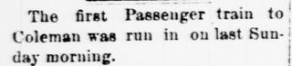
The Taylor County News of
Friday, March 12, 1886 reported that the first passenger train into
Coleman had arrived on March 7th.
 |
 |
West of Coleman Junction, the surveyed GC&SF
right-of-way to San Angelo crossed the Colorado River five miles south of
Runnels City, the seat of Runnels County. Though they tried their best
(including a direct appeal to GC&SF management in a meeting at Galveston), the 250
residents of
Runnels City could not convince the GC&SF to build through their town. Instead,
on the north bank of the Colorado River, the GC&SF founded a new town,
Ballinger, named for prominent Galveston attorney
and GC&SF stockholder William Ballinger. The tracks reached Ballinger in May or
June, and a public sale of town lots was held on June 29, 1886. Ballinger
remained the western terminus of the GC&SF for more than two years as their construction focus turned elsewhere.
In March,
1886, negotiations led by GC&SF President George Sealy
resulted in an agreement under which the much larger Atchison, Topeka & Santa Fe
(AT&SF) Railway would acquire the GC&SF on favorable terms if the GC&SF
quickly completed three
construction projects. The GC&SF was able to lay three hundred
miles of track in one year to finish all of the projects, but none of them pertained to the northwest
extension. The acquisition proceeded as planned in 1887 and the GC&SF began
operating as a wholly-owned subsidiary of the AT&SF.
Construction
west from Ballinger across the Colorado River toward San Angelo, 36 miles away,
commenced in late May, 1888. A story in the Austin Weekly Statesman
of May 31, 1888 noted that
San Angelo's railroad committee was "...having some annoyance in
securing right-of-way and depot grounds..." which had been promised to the
railroad. The situation was no better at Ballinger. On the San Angelo side of the
Colorado River "...right-of-way has been purchased at the rate of $150 per
acre...about two miles from town, which could not have been sold for more than
$5 or $10 per acre." The planned route of the railroad beyond Ballinger was
known, hence land prices nearby had
skyrocketed. The first construction train was reported into San Angelo on August
6th, and Santa Fe officially accepted the line from the contractors in early
September.
 |
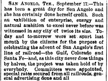
San Angelo had been founded only twenty years earlier
when Fort Concho was established to help protect the frontier. The town
was settled where the North, South and Middle Concho Rivers joined,
providing a good water supply. Along with plenty of suitable pasture
land, it became the center of a vast ranching area. Hauling livestock was a
significant business for railroads, and San Angelo became one of the biggest livestock shipping points in
the country.
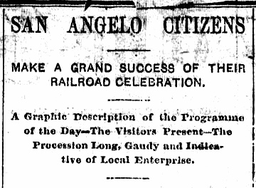
Left and
Right: San Angelo's citizens, perhaps all 2,000 of them,
celebrated the arrival of the GC&SF. The story conveys the "gaudy"
pageantry and palpable excitement of the residents of this isolated town upon finally
getting modern transportation to the outside world. (Galveston
Daily News, September 18, 1888) |
 |
In 1891, the new town of Sterling City was founded
along the North Concho River about forty miles northwest of San Angelo. Despite
the distance, it was still in Tom Green County, so its citizens petitioned the
Legislature to carve out a new county so they could avoid the arduous eighty
mile round trip for county business. Although the Legislature granted the
request, San Angelo remained the major population center in the area, hence
Sterling City locals frequently needed to travel there for various goods and
services. In 1909, residents of Sterling City and elsewhere in the region
chartered the Concho, San Saba & Llano Valley (CSS&LV) Railroad. The plan was to
build in two directions out of San Angelo: northwest to Sterling City and
southeast to reach communities along the Concho River (Paint Rock), the San Saba River
(Menard) and the Llano River (Junction). The long term objective was to continue
beyond Sterling City to Lubbock.
Santa Fe agreed to finance the CSS&LV construction
and to provide trackage rights on the GC&SF between San Angelo and Miles, a
community midway between San Angelo and Ballinger. Miles became the branch
point for a 17-mile CSS&LV line to Paint Rock for which work began in
1909. Construction of a 43-mile line from San Angelo to Sterling City also
began in 1909.
Service commenced in August, 1910 and the CSS&LV was acquired by the AT&SF that
same month and leased to the GC&SF. There was no additional construction under
the CSS&LV charter. The Miles - Paint Rock branch lacked the revenue to sustain
it and was abandoned in 1937. The San Angelo - Sterling City segment lasted
longer, but was abandoned in 1959.
Right:
Railroads near San Angelo in the 1885 - 1912 timeframe
Texas & Pacific: The T&P served
Fort Worth and El Paso,
having built through Abilene in 1881.
Atchison,
Topeka & Santa Fe: The AT&SF acquired the GC&SF in 1887, and financed
the Concho, San Saba & Llano
Valley, buying it in 1910.
Abilene & Southern:
The original concept of an "Abilene & San Angelo" railroad was never
built. The A&S was built to Ballinger
in 1909 and became part of the T&P in 1926.
Pecos & Northern Texas: The P&NT was the
AT&SF subsidiary that built the northwest extension from
Coleman to Slaton in 1911. It crossed the A&S at Tuscola.
Kansas City, Mexico
& Orient: The KCM&O planned to build from Kansas City to Topolobampo,
Mexico on the Gulf of California as a short route to a Pacific
port. The line passed through San Angelo in 1909 - 1910. |
 |
Santa Fe alone served San Angelo until a second
railroad arrived in 1909. It was the brainchild of Arthur Stilwell, a
New Yorker who had settled in Kansas City in 1886. As a railroad promoter,
Stilwell's concept for rails out of Kansas City was to find the shortest
route to the nearest deep water port. He first practiced this strategy when he founded the
Kansas City, Pittsburg and Gulf Railroad. The idea was simple; build due south
from Kansas City through Pittsburg (Kansas), Texarkana and
Beaumont to reach a
new port on the Gulf of Mexico that he named for himself,
Port Arthur, Texas.
The line commenced operation in late 1897, but when it went into foreclosure in
1899, Stilwell lost his investment and was booted off the management team. The company was financially
reorganized as the Kansas City Southern Railway, which remains a major railroad
today.
To say the least, Stilwell was unhappy with the banking interests that
had forced him out. His closest friends were concerned about his well-being, so to
cheer him up, they hosted a special dinner in his honor on February 10, 1900.
Stilwell gave a speech to the assembled guests, thanking them for the dinner and
their attendance. He then took the opportunity to unveil his newest plan: the
Kansas City, Mexico & Orient Railway.
Above: KCM&O Railway ten share
common stock trust certificate issued to A. E. Stilwell on July 21, 1908
(Charles Alspach collection)
Left:
the route of the KCM&O from Kansas City to Topolobampo, Mexico
Turning his attention to the Pacific Ocean, Stilwell was following the same
script: build a rail line from Kansas City directly to the nearest deep water
port, which happened to be at Topolobampo, Mexico on the Gulf of California. The
estimated rail distance was approximately 400 miles shorter than the existing
route from Kansas City to California. Two months after the dinner, Stilwell
signed an agreement with the President of Mexico, Porfirio Diaz, wherein the
Mexican government agreed to subsidize the KCM&O's construction in that country
at the rate of $5,000 per mile. Diaz fully expected that the rail line's route through
an under-developed area of Mexico would facilitate access to
untapped mineral resources and timber lands.
Construction proceeded at
various locations in Mexico, Kansas and Oklahoma. In Kansas, Wichita became the north
end of the line instead of Kansas City until a connecting track segment could be
built. To comply with Texas' railroad laws, Stilwell would need a
separately chartered railroad headquartered in state. S. G. Reed, in his
definitive work A History of the Texas Railroads
(St. Clair Publishing, 1941), explains how Stilwell obtained one...
Stilwell, in a preliminary survey to determine the route through Texas,
discovered a little railroad which had been chartered in Texas on July 15, 1899,
as the Panhandle & Gulf Ry. to build from Sweetwater to San Angelo.
This little railroad had, also, been organized to take over another local
enterprise which had been chartered as the Colorado Valley Railroad Co.
to build between the same two cities, which already had seven miles completed
out of Sweetwater. Stilwell had the charter of the P. & G. amended on
March 3, 1900, to permit him to take it over under the name of the Kansas
City, Mexico & Orient Railway Co. of Texas and also to extend it to the Red
River on the north and the Rio Grande on the south.
This charter also
gave the right to build a branch line from San Angelo to Del Rio. As this road
would traverse a territory much of which was without railroad facilities and
would also strengthen those communities which already had them, such as
Sweetwater, San Angelo and Alpine, by enlarging their trade territory and
shortening the distance to markets, it was assisted by liberal donations. ...
The construction of the Texas line began at Sweetwater in 1904.
 |
Building north from Sweetwater,
the KCM&O reached the Pease River in the fall of 1908. Crews working
south from Oklahoma crossed the Red River and reached the Pease shortly thereafter. Service between
Sweetwater and Wichita, Kansas began on January 31, 1909. Going south from Sweetwater, construction commenced in the spring of
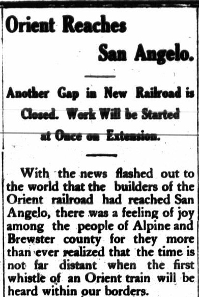
1909 and reached San Angelo in September. The KCM&O was destined
for Alpine, so it made sense to build their San Angelo depot south of the
North Concho River, which ran through the middle of town. Santa Fe, with no plans to build farther south, had
erected their depot north of the
river.
Left:
Fort Worth Record and Register,
Sept. 18, 1909 Right:
Alpine Avalanche, Sept.
23, 1909
Construction of the
KCM&O main line southwest from San Angelo toward Fort Stockton began in 1910;
the first 28 miles to Mertzon opened on March 31, 1911. A year later,
the KCM&O entered receivership and construction stopped until the
Receiver could take action. Work slowly resumed and the first passenger
train into Fort Stockton finally arrived in November, 1912. By then, most of the
grading to Alpine had been completed. Service to Alpine began in 1913
while the railroad remained in receivership. |
 |
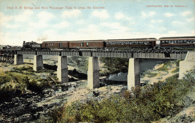 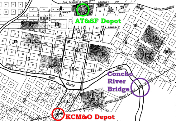
Above:
annotated Sanborn Fire Insurance Map of San Angelo, 1913
Left:
"First R. R. Bridge and First Passenger Train to cross the Conchos" ((c)
1909 M. C. Ragsdale, courtesy Texas Transportation Archive,
Murry Hammond
collection) |
|
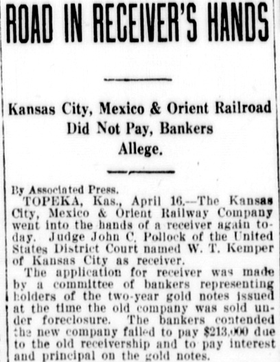
The KCM&O's March, 1912 receivership is easily traced to a lack of local traffic
along the line. The KCM&O mostly ran through sparsely populated areas where
there simply wasn't enough commerce to sustain the enterprise. The original
idea of shipping from the Midwest to the Pacific port of Topolobampo could not
be executed until the track segment through Mexico was complete. Unfortunately
for the KCM&O, that would be in the distant future due to the difficulty of
building across Copper Canyon in Mexico.
Until there was a need for a rail bridge over the Rio Grande, the end of track
remained at Alpine where it connected into the Southern Pacific (SP) Sunset
Route. The Bankruptcy Court had authorized Receiver Certificates to fund the
remaining track-laying from Fort Stockton to Alpine under the theory that the SP
connection might generate sufficient traffic to bring the KCM&O into
profitability. The receivership ended in June, 1914, but the Alpine interchange
didn't make much of a difference in the railroad's overall financial situation,
and it went back into receivership in 1917.
 |
Left: The San
Antonio Express of April 17, 1917 reported that the KCM&O had
gone into receivership "again" with William T. Kemper, Sr. of Kansas
City named Receiver. Kemper was a well-known banker and the patriarch of
the Kemper family respected as major Kansas City benefactors.
Kemper signed a contract
with the U. S. Railroad Administration (USRA) in June, 1918, covering
KCM&O's participation in the USRA's national management of railroads
during World War I. Some creditors urged USRA to
cancel the contract so that Kemper could be forced to liquidate the
railroad's assets, but USRA refused. Even when control of the KCM&O
returned to Kemper after the War, he was able to keep the KCM&O alive just long enough to
get lucky; a major oil discovery in 1923 at Big Lake southwest of San
Angelo soon had the KCM&O shipping large quantities of crude oil.
But production was so substantial that pipelines were laid to the area and
oil shipments by rail dwindled.
Despite the oil bonanza, the
bankruptcy judge forced the KCM&O to be sold in 1924 to pay back
approximately $3 million in debt
owed to the U. S. Government. The high bid was made by Clifford Hister,
Kemper's chief counsel. The financial transactions that ensued were very complex
and subject to a
lengthy court battle that wasn't settled until March, 1927. In the
end, Kemper was the KCM&O's
President. He put the railroad up for sale and was able to secure Santa
Fe's bid buy it. The sale of the KCM&O to Santa Fe was approved by the
Interstate Commerce Commission (ICC) on August 28, 1928. |
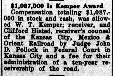
Above: The July 14,
1927 issue of the Paducah Post
reported that the Federal Judge overseeing the KCM&O's bankruptcy had
awarded Kemper and Hister nearly $1.1 million as a fee for managing the
receivership of the KCM&O for ten years. The award amount was
appealed, and the Eighth Circuit Court of Appeals reduced it to $800,000
in June, 1928. |
 Santa Fe bought the KCM&O along with its Mexican counterpart, the KCM&O of Mexico.
The KCM&O's operations
were quickly integrated with other Santa Fe components but the Mexican line was
sold; it still did not reach
Topolobampo and wouldn't until 1961. A line to the border at Presidio
was built that departed SP's Sunset Route
at Paisano Pass (west of Alpine, reached via trackage rights on SP.) The first
train arrived at Presidio on November 2, 1930. A bridge over the Rio Grande had
been constructed, so the train proceeded on a goodwill tour to Chihuahua,
Mexico. The entire event and tour was filmed by Fox Movietone (with sound!) Santa Fe also built the branch line from San Angelo to
Sonora that KCM&O had planned. The first train reached
Sonora in May, 1930.
Santa Fe bought the KCM&O along with its Mexican counterpart, the KCM&O of Mexico.
The KCM&O's operations
were quickly integrated with other Santa Fe components but the Mexican line was
sold; it still did not reach
Topolobampo and wouldn't until 1961. A line to the border at Presidio
was built that departed SP's Sunset Route
at Paisano Pass (west of Alpine, reached via trackage rights on SP.) The first
train arrived at Presidio on November 2, 1930. A bridge over the Rio Grande had
been constructed, so the train proceeded on a goodwill tour to Chihuahua,
Mexico. The entire event and tour was filmed by Fox Movietone (with sound!) Santa Fe also built the branch line from San Angelo to
Sonora that KCM&O had planned. The first train reached
Sonora in May, 1930.
Except for brief periods, the
KCM&O was never a paying railroad. The physical
dismantling of its route began
in 1977 when the branch to Sonora was scrapped. In 1982, 53 miles was abandoned
between the north side of San Angelo and the community of Maryneal, fifteen
miles south of Sweetwater. The KCM&O tracks from Maryneal to Cherokee,
Oklahoma were sold to the Texas & Oklahoma (T&O) Railroad in 1991. The T&O
abandoned the segment from Sweetwater
to Elmer, Oklahoma in 1995, but the tracks south of Sweetwater were retained,
and they
remain intact today to serve a large cement plant at Maryneal.
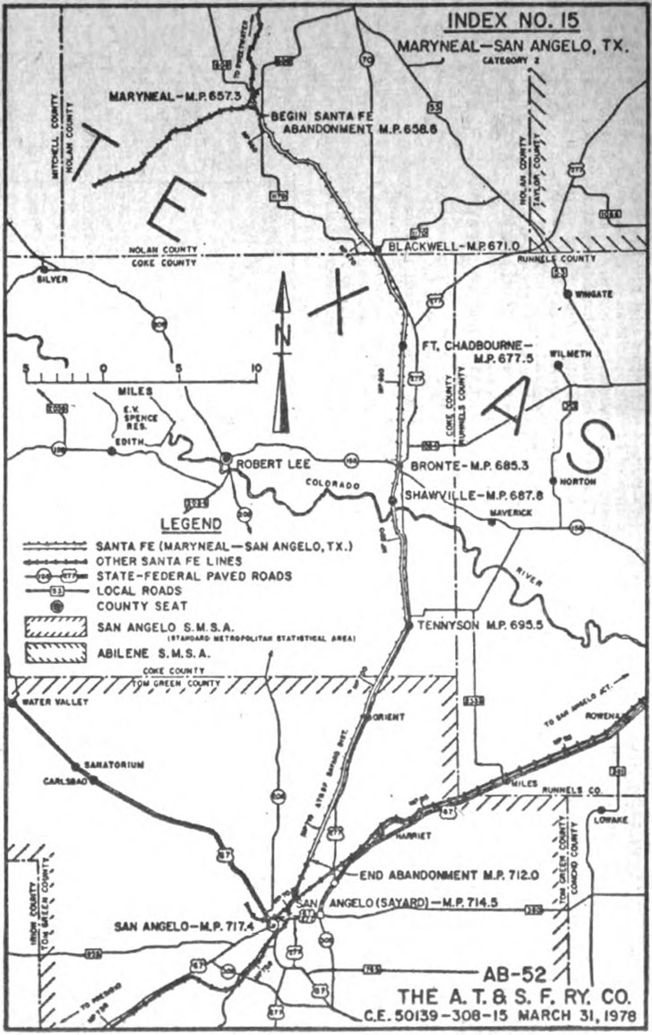
Right: On September 19, 1978, approximately
four years prior to the abandonment between Maryneal and San
Angelo, this map (dated March 31, 1978) was published in the
Federal Register to provide legal notice
that Santa Fe was studying "Maryneal to San Angelo, a 53.4 mile segment of the
Sayard District" for potential abandonment proceedings. Santa Fe timetables show
that at least since 1949 and probably earlier, Santa Fe had proclaimed the former
KCM&O from Hamlin to San Angelo to be the Sayard District of the Slaton Division
of the Panhandle & Santa Fe Railway, a subsidiary that
operated lines in the Texas Panhandle and other parts of northwest Texas. Sayard
was a yard a short distance north of the Tower 82 crossing, but there was no community
by that name. To have named a district for it, Sayard must have been a major yard for Santa Fe. [Was "Sayard" a concatenation of "S. A. Yard", i.e. "San Angelo
Yard", possibly renamed to avoid confusion with the small yard located near the
Santa Fe freight station closer to downtown San Angelo? Enquiring minds want to
know...]
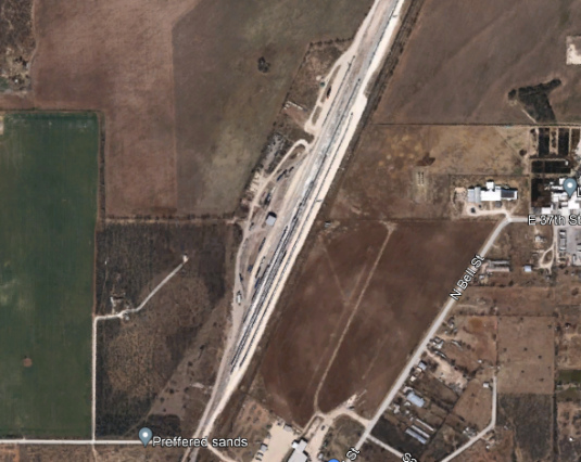
Below: A yard remains in
operation at what is presumably the former location of Sayard a short distance north
of the Tower 82 crossing. (Google Earth 2021)
In
the early 1990s, Santa Fe attempted to sell its entire remaining route through San Angelo
to a company willing to buy it for the scrap value of the rails and other
components. Fearing the loss of a unique transportation corridor in an
underserved section of the state, the Texas Department of Transportation (TxDOT)
stepped in to acquire the right-of-way. The Legislature established the South
Orient Rural Rail Transportation District to acquire the track and other items
directly from Santa Fe. A new company, the South Orient Railroad, was founded to
acquire the operating rights and obligations for the line from Santa Fe. South
Orient operated the tracks from San Angelo Junction on the
Santa Fe main line to Presidio on the Rio Grande, a total of 376 miles. The
segment from San Angelo to Presidio was KCM&O heritage; the segment between San
Angelo and San Angelo Junction was GC&SF heritage.
In June, 1998, South
Orient applied to the Surface Transportation Board (STB) for permission to
abandon the line from San Angelo to Presidio. Instead, the Legislature funded TxDOT to acquire all of South Orient's interests and arrange to lease operation
of the entire rail line. A new company based in San Angelo,
Texas Pacifico Railroad, took the
lease. STB approved this arrangement on December 11, 2000, and
Texas Pacifico continues to operate the line today.
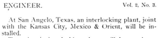
Above: In June, 1909,
The Signal Engineer had this item
in an article about Santa Fe's interlocking plans
for the year. |

Above: The RCT interlocker list of October 31, 1910
shows that Tower 82
began operation on February 25, 1910.
Below: RCT's list of inactive interlockers dated December 31, 1930
included Tower 82, but reported its original commissioning date as December 28, 1910
instead of February 25, 1910. This was Tower 82's first appearance in
the list of inactive interlockers.
 |
In the book The Orient, the authors assert that
Tower 82's construction began on September 1, 1910 and was completed on February
25, 1911. If so, RCT's originally published commissioning date was off by
exactly one year. The truth may lay somewhere in between, perhaps the revised
date of December 28, 1910. In RCT's interlocker list published at the end of
1916, Tower 82's commissioning date was left blank. Each annual list of active
interlockers continued with the blank commissioning date until the list dated
December 31, 1923 reinserted the original date. Even RCT was confused.
Tower 82 initially had sixteen functions; the minimum count for a basic crossing was twelve, consisting
of a home signal, distant signal and derail in each of the four directions. The
purpose of its four additional functions is undetermined,
but could indicate the presence of a connecting track (aerial imagery shows a
northeast quadrant connecting track present in 1954.) In RCT's published table of
active interlockers dated October 31, 1916, the function count increased to eighteen.
This was also the first RCT table that identified the railroad responsible for
operating and maintaining the interlocker; for Tower 82, it was the GC&SF. This
suggests that the GC&SF took the lead on designing the tower and interlocking system
because typically, the railroad that built the interlocker also handled
operations
and maintenance (O&M) staffing, at least at the outset. Under state law, KCM&O -- the railroad
that created the crossing when it built across the GC&SF -- would have been
responsible for funding the capital expense for the tower, interlocker and associated signals. (Had the crossing existed before 1901,
the capital expense would have been shared.) In most cases, the
railroad that funded the tower would also take the lead in building it, but it
is likely that by the time the tower was being planned for San Angelo, Santa Fe
already knew it would soon be building across the KCM&O at Sweetwater. There,
they would be the second railroad and thus would be obligated to fund the capital
expense for the tower in Sweetwater, eventually nomenclatured by RCT as Tower 88. Since
the KCM&O had
no experience in designing and building interlocking towers, and given that Santa
Fe would need to fund the capital outlay for the Sweetwater tower within a year
or so, it is likely that the two towers were identical designs (but
unfortunately, this is merely conjecture as no photo of the Sweetwater tower has
surfaced.)
The photo
of Tower 82 at the top of page shows a structure that resembles other GC&SF towers, but not
precisely (see Tower 23,
Tower 24 and Tower 52 for examples.) Like the
others, Tower 82 is constructed with narrow, horizontally mounted wood boards
and four upper floor windows, at least on the visible side. The far wall windows
that are visible through the near windows appear to be the correct distance for
a square floor plan, another common element of GC&SF towers. The roof overhang,
however, appears to be smaller, and there is no obvious accent paint scheme
(perhaps merely a function of when the photo was taken.)
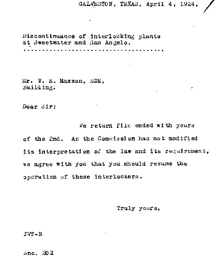 Left:
This letter was sent to W. E. Maxson, Assistant General
Manager ("AGM") of the GC&SF, in 1924. The best guess is that it was written by an attorney
at the GC&SF corporate office ("Galveston"), someone Maxson
recognized simply by the initials, and it was sent to Maxson's office in
the same location (addressed simply as "Building.") It suggests that Maxson had
requested a legal opinion regarding interlockers at Sweetwater
and San Angelo that had been taken out of service by Santa Fe at some unknown date. The author agreed with Maxson's position that Santa Fe
should resume operation of both interlockers. The "interpretation of the law" referenced in
the letter relates to legal issues that had been raised
regarding the extent of RCT's authority over interlockers. For example, since
Texas' interlocker law specifically referred to a crossing of "another company",
could RCT order an interlocker
installation for a junction where all of the tracks belonged to the same company?
Could RCT require a railroad to seek approval of an interlocker that the
railroad had voluntarily installed for its own purposes? Under what
circumstances (if any) did a railroad have an inherent right to stop operating
an interlocker (e.g. bankruptcy, merger?) Some of these issues had already surfaced with respect to
other interlockers (see
Tower 5, Tower 116 and Tower 121),
and the issue would come back to haunt Santa Fe when they voluntarily chose to install an interlocker at Canyon
in 1927. (Santa Fe Legal Archives, Houston Metropolitan Research Center. Thanks to Stephen Hesse
for finding this document.)
Left:
This letter was sent to W. E. Maxson, Assistant General
Manager ("AGM") of the GC&SF, in 1924. The best guess is that it was written by an attorney
at the GC&SF corporate office ("Galveston"), someone Maxson
recognized simply by the initials, and it was sent to Maxson's office in
the same location (addressed simply as "Building.") It suggests that Maxson had
requested a legal opinion regarding interlockers at Sweetwater
and San Angelo that had been taken out of service by Santa Fe at some unknown date. The author agreed with Maxson's position that Santa Fe
should resume operation of both interlockers. The "interpretation of the law" referenced in
the letter relates to legal issues that had been raised
regarding the extent of RCT's authority over interlockers. For example, since
Texas' interlocker law specifically referred to a crossing of "another company",
could RCT order an interlocker
installation for a junction where all of the tracks belonged to the same company?
Could RCT require a railroad to seek approval of an interlocker that the
railroad had voluntarily installed for its own purposes? Under what
circumstances (if any) did a railroad have an inherent right to stop operating
an interlocker (e.g. bankruptcy, merger?) Some of these issues had already surfaced with respect to
other interlockers (see
Tower 5, Tower 116 and Tower 121),
and the issue would come back to haunt Santa Fe when they voluntarily chose to install an interlocker at Canyon
in 1927. (Santa Fe Legal Archives, Houston Metropolitan Research Center. Thanks to Stephen Hesse
for finding this document.)
This letter is difficult to interpret
within the context of what is known about the interlockers at San Angelo and
Sweetwater. Both were operated by Santa Fe and both involved the KCM&O as the
other railroad (KCM&O also had an interlocker at
Chillicothe that did not involve Santa Fe.) At an unknown date the GC&SF
discontinued operating these interlockers, but Maxson had concluded that restarting
them might be required under RCT rules. Since KCM&O was paying half of the
interlockers' O&M expenses, had the railroads agreed to suspend operations so
KCM&O could save money when it reentered receivership in 1917? Was it
required by the bankruptcy Receiver? Did Santa
Fe do it on their own because KCM&O had stopped paying their share of tower
expenses, or because KCM&O's train count had dropped so low that a manned
interlocker made no sense? Had KCM&O complained to Santa Fe or to RCT about the
suspended interlockers? By 1924, KCM&O was shipping large quantities of Big Lake
crude eastward. Such trains would have been long and heavy, with no need to stop
in San Angelo, precisely the type of train that would be penalized the most by
being forced to stop before crossing the Santa Fe diamond if Tower 82 was inactive. Did
the San Angelo and Sweetwater interlockers have any other common factors that made
them candidates to be closed? Does the removal of the Tower 82 commissioning
date in RCT's annual lists from 1916 through 1922 pertain to this subject at
all? These are questions that require additional research through Santa Fe's
archives.
Tower 82 first appeared in RCT's annual list of
inactive interlockers at the end of 1930. This was the final
comprehensive list of active and inactive interlockers that RCT ever published.
Since Santa Fe owned both rail lines, it made sense to seek RCT permission to decommission Tower 82
(which RCT apparently granted, given Tower 82's inclusion in the list of retired
interlockers.) Based
on the suspension referenced in the letter to Maxson, Santa Fe had presumably
for several years held the belief that Tower 82 was not cost-effective for their
operations through San Angelo. Apparently there would be few trains materially
impacted by the need to come to a complete stop before crossing the diamond,
whereas the cost of staffing and maintaining the interlocking tower would be
significant. Given Tower 82's relatively early demise and its location on the
north outskirts of San Angelo (far from town back in the 1920s), it is perhaps
not surprising that no reports
have surfaced regarding the dismantling and disposition of the tower.
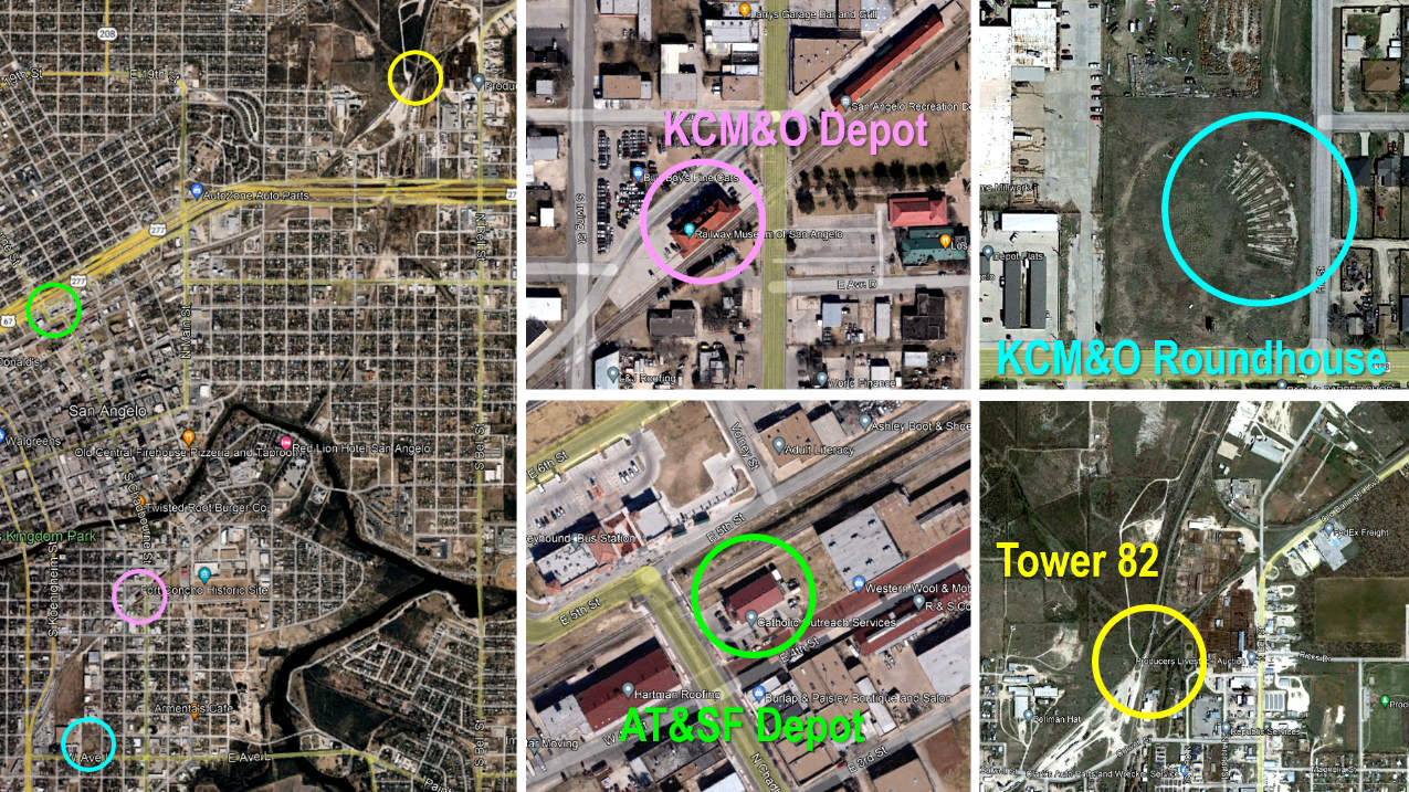
Above: These March, 2021
Google Earth images are annotated with key locations in San Angelo railroad
history:
Although the name "Alvery Junction" has come to be
associated with the area near the Tower 82 crossing, Santa Fe timetables always referred to Tower 82 as
"Alvey Junction." The source of this discrepancy has not been determined. South of the
junction, the GC&SF tracks
were severed when the US 277 expressway opened in the mid-1990s. A connection
between the KCM&O tracks and the GC&SF tracks was built parallel to and
south of the freeway to retain access to industries located along the GC&SF
tracks in north San Angelo. North of Alvey Junction, the connecting
track visible in the image has existed since at least 1954. Does this interchange track date back to when Tower 82
was erected? RCT reported the
interlocker having four functions beyond the minimum, e.g. perhaps a switch and
a signal at each end of the connector? Farther north (but not on these images), the former Sayard
facility
is still in use, and a new San Angelo Rail
Park is under construction as of June, 2022.
Timetables show that at least
by 1945 (and probably many years earlier), Santa Fe had
relocated its passenger operations to the KCM&O depot. This required
passenger trains on the San Angelo District
(east to San Angelo Junction or west to Sterling City) to detour 2.2
miles on the Sayard District south from Alvey Junction to reach the depot.
The Santa Fe
depot (dating to 1908 or earlier) remains standing as a facility for Catholic Outreach Services.
West of the depot, the tracks end just beyond W. 19th St. on the former route to
Sterling City. Remnants of the KCM&O roundhouse
are visible in a large field at the
intersection of Hill St. and W. Ave. L.
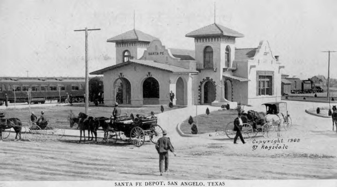
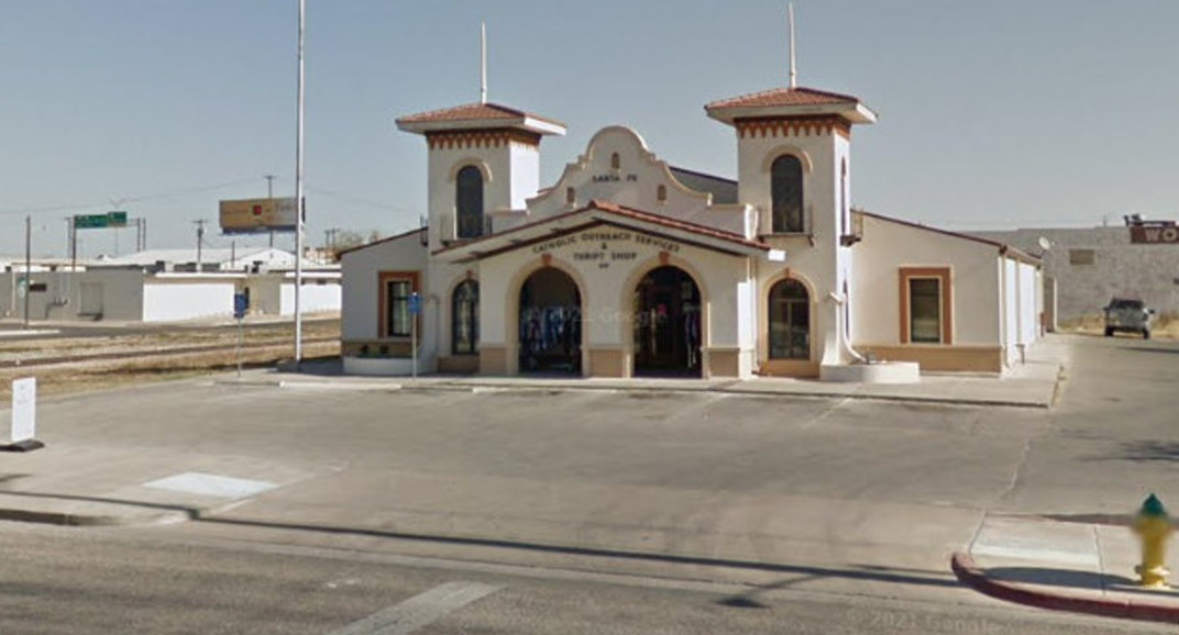
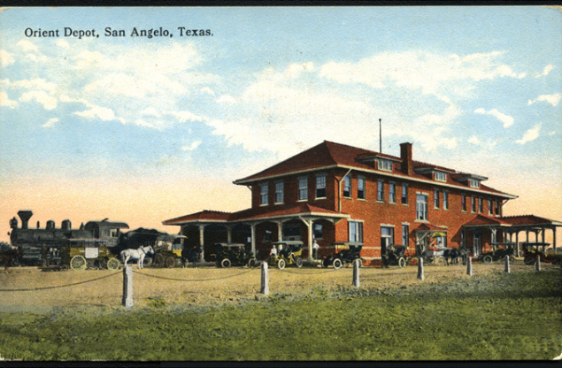
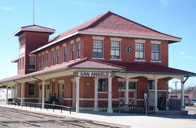
Above:
the Santa Fe passenger depot in San Angelo:
left,
Margay Welch collection, 1908; right, a Catholic Outreach Services facility -- Google Street View,
2012
Above Left: the KCM&O depot,
(c) M. C. Ragsdale c.1910 (courtesy of the Texas Transportation Archive, Murry
Hammond collection) Above Right: The
Railway Museum of San Angelo
was established in 1996 housed in the former KCM&O depot. At some point, Santa
Fe moved all of their passenger operations to this depot. The last regularly scheduled passenger train departed the depot on June 20,
1965. Santa Fe deeded the facility to the city of San Angelo in 1989 and it was
restored over several years. (William Fischer, 2014)
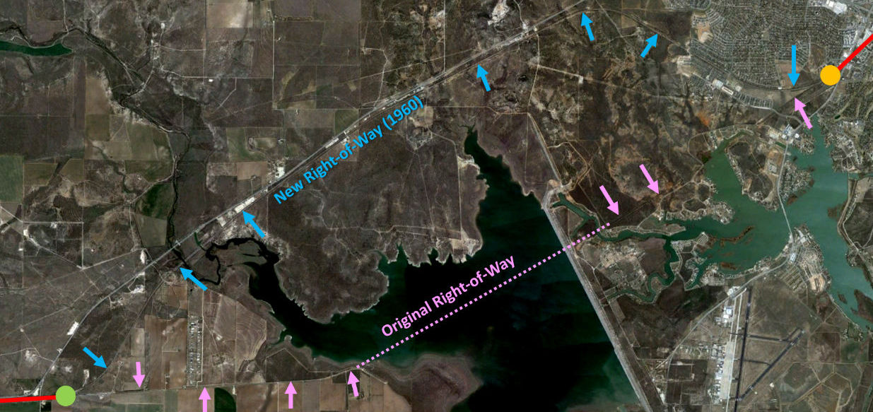
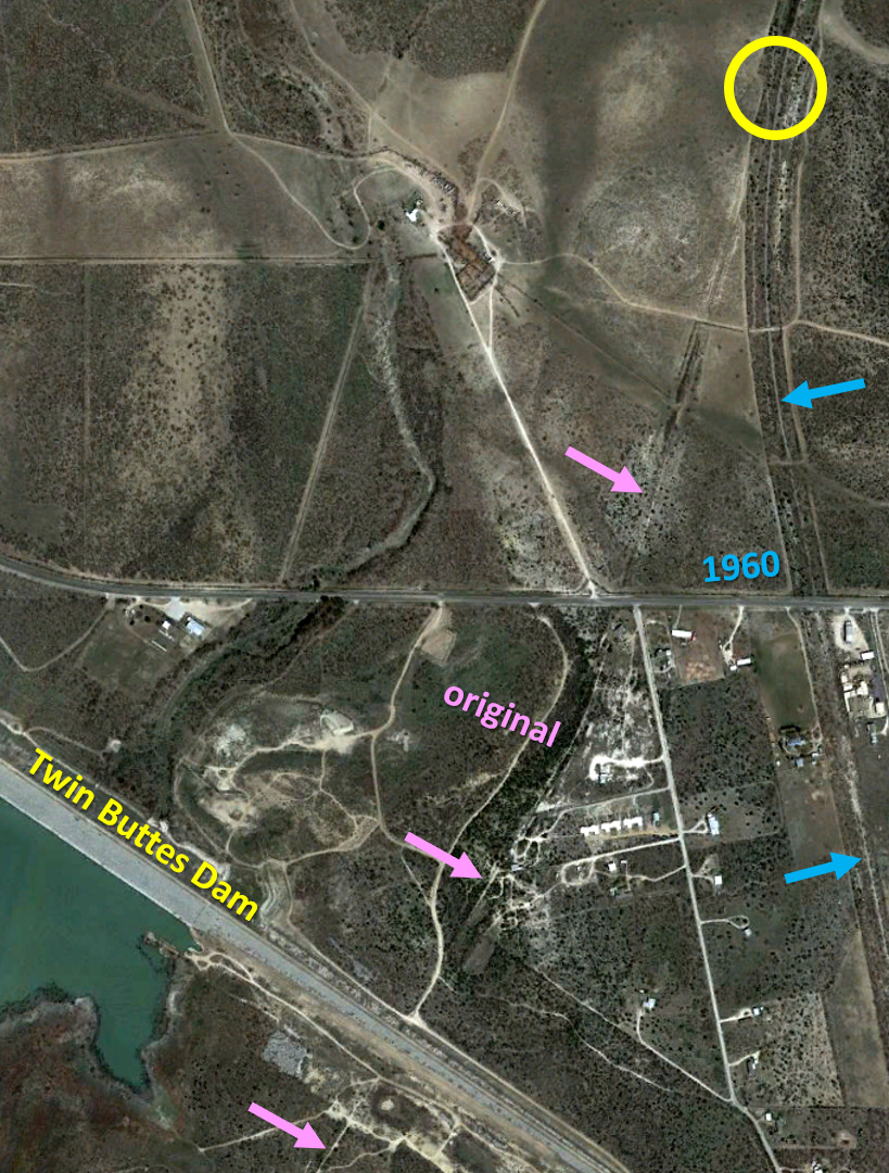
Above: In 1960, construction
of the Twin Buttes Dam began for the purpose of impounding Twin Buttes
Reservoir southwest of downtown San Angelo. Santa Fe's tracks to Fort Stockton
passed through the middle of it, so they were realigned to go around the north
side. The red solid lines are the unaffected parts of the right-of-way leading
to the east junction (orange circle) and west junction (green circle.)
 Left:
The Twin Buttes Dam is an unusual design that
separately dams both the Middle and South Concho Rivers with a rolled earthfill
embankment nearly eight miles long. In addition to requiring a relocation of
Santa Fe's tracks to Fort Stockton, the south end of the dam also crossed Santa Fe's tracks to Sonora, requiring a relatively short realignment. The new
right-of-way (blue arrows) began at the yellow circle (at coordinates 31 19 38
N, 100 28 27 W) and rejoined the original right-of-way (pink arrows) about three
miles farther south (at 31 15 59 N, 100 29 40 W).
Left:
The Twin Buttes Dam is an unusual design that
separately dams both the Middle and South Concho Rivers with a rolled earthfill
embankment nearly eight miles long. In addition to requiring a relocation of
Santa Fe's tracks to Fort Stockton, the south end of the dam also crossed Santa Fe's tracks to Sonora, requiring a relatively short realignment. The new
right-of-way (blue arrows) began at the yellow circle (at coordinates 31 19 38
N, 100 28 27 W) and rejoined the original right-of-way (pink arrows) about three
miles farther south (at 31 15 59 N, 100 29 40 W).
In hearings held in
1957 before the U. S. House of Representatives Interior and Insular Affairs Committee,
witness Robert W. Jennings of the Bureau of Reclamation stated... "Twin Buttes
Dam would span both the Middle and South Concho Rivers just upstream from Lake Nasworthy and the municipal airport, Mathis Field."
Nevertheless, the dam was more frequently called the "Three Rivers Dam" by San
Angelo civic leaders, particularly Houston Harte, the Publisher of the
San Angelo Standard (and co-founder of the
major communications company,
Harte Hanks.)
The outflow from Twin Buttes Reservoir flows into Lake Nasworthy, a small lake
built in 1930 as a municipal water supply for San Angelo.
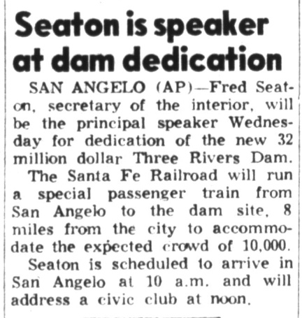
Below: The
Levelland Daily Sun News of June 21, 1960
noted that Santa Fe was running a special train to "Three Rivers Dam" for
its dedication at which Secretary of the Interior Fred Seaton would
be the principal speaker. The Twin Buttes name eventually won out, perhaps to
avoid conflict with a dam built near Three Rivers, Texas for Choke Canyon
Reservoir.