Texas Railroad History - Tower 128, Ballinger and Tower
129, Tuscola
Two Crossings of the Abilene and
Southern Railway and the Santa Fe Railway South of Abilene
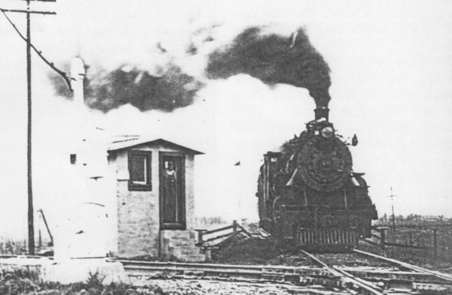 |
Left: In this undated
photo from the A. C. Greene collection (Journal of Texas Shortline
Railroads, Vol. 2, No. 1, 1997), an Abilene & Southern (A&S) locomotive
is passing the Tower 129 cabin interlocker at Tuscola. Prior to crossing
the Santa Fe tracks in the foreground, A&S trains would stop so that a
crewmember (presumably the man in the doorway) could enter the cabin to
set the interlocker controls to display STOP on Santa Fe's home and
distant signals, and activate its derails. The interlocker would delay
effecting the changes for a suitable period should a Santa Fe train
already be near the crossing. After the A&S home signal changed to PROCEED
and the derails were cleared, the train could proceed over the diamond. The
controls
would then be reset to the standard position, reversing the signals and
derails on both tracks to grant unrestricted movements for
Santa Fe trains. The A&S had no distant signals at Tower 129.
Instead, fixed signs reminded approaching trains they were nearing the Santa Fe crossing and
that a stop at the cabin was
required.
The
semaphore-style home signal is barely visible trackside to the left
behind the locomotive (a better picture from the opposite direction is
below.) The most likely scenario is that the
locomotive had stopped short of the home signal (failing to do so
would derail the locomotive.) The crewmember disembarked to enter the
cabin and change the
controls. The PROCEED signal was granted and the
derails were cleared, hence the locomotive moved forward and is about to cross the
diamond. The crewmember will set the controls back to the normal
position and reboard his train heading northeast to Abilene. |
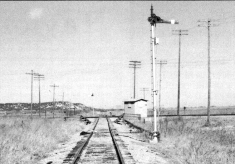
Right:
This undated photo is from the collection of Joe Dale Morris (Journal of Texas Shortline
Railroads, Vol. 2, No. 1, 1997.) The view is northeast along the A&S
toward Abilene. The horizontal home semaphore indicates STOP, and what
may be a derail mechanism on the left rail (just beyond the signal pole)
appears to be engaged (i.e. over the rail.)
The Tower 129 cabin and
interlocking plant were installed by Santa Fe which also took
responsibility for maintenance. As the second railroad at the crossing,
Santa Fe funded the capital expense, but the recurring expenses for
utilities and maintenance were shared by both railroads. After a final
inspection by the Railroad Commission of Texas (RCT), the plant was
placed in service on
March 15, 1927. RCT records show the Tower 129 interlocking plant having
six functions, but their allocation among combinations of signals,
switches and derails is undetermined. At least by 1937 and perhaps from
the outset, there were switches at both ends of a connecting track in
the east quadrant that may have been controlled from the cabin.
Tower 129 was the last of three consecutive cabin
interlocker projects that RCT authorized for Santa Fe, probably
in the summer of 1926. The others were Tower 127 at Tenaha and Tower 128
at Ballinger. The tower numbers reflect
the order in which projects were initiated, but they do not indicate the
order of installation. Every project was different; some took longer to
complete than others. Though it was the last to be started, Tower 129
was the first to commence operations. Six weeks later, Tower 128 began
operation on April 27, 1927. It very likely had the same design, but no photographs have been found.
About a year later, Santa Fe installed Tower
127, an almost identical cabin. A
year after that, another virtually identical Santa Fe cabin,
Tower 152 at Wharton, was commissioned. |
 |
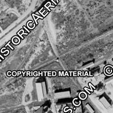
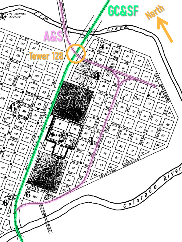
Right: This aerial image from 1937 ((c)
historicaerials.com) shows the A&S (pink arrows) and the Gulf, Colorado
& Santa Fe (GC&SF) Railway (green arrows) at Ballinger. The tracks
formed an 'X' pattern (yellow circle) in which the Tower 128 cabin is visible as a white dot in the
south quadrant. It was probably identical to the Tower
129 cabin. The image shows a connecting track (blue arrow) between the two
railroads in the west quadrant. North of the crossing, Park Avenue
passed over the A&S on a bridge (red oval.) All three of the Elm Creek
bridges -- Park Avenue, the A&S, and the GC&SF --
are visible in the image.
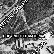
Above: Twenty years
later, the Tower 128 cabin casts a prominent shadow to the north in this
image from 1957 (left.)
Though another two decades elapsed, it was still standing to cast a
shadow to the west in this 1976 image (right)
some four years after the A&S line was abandoned at Ballinger. The cabin was removed at least by 1983 per
historic aerial imagery. (both images (c) historicaerials.com) |
 |
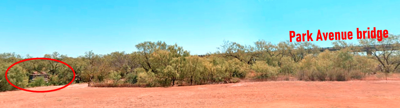
Above: This August, 2023
Google Street View facing east from a parking area in the Ballinger City Park
shows an A&S bridge abutment (red oval) at the south bank of Elm Creek. The A&S
tracks continued south in the foreground semi-parallel to the Park Avenue bridge and then curved
east to pass beneath the roadway, heading for Tower 128.
In 1881, the Texas & Pacific (T&P) Railway worked with
ranchers and other landowners in Taylor County to found the town of Abilene as
it built west toward El
Paso. With substantial
population growth, Abilene incorporated in 1883, becoming the county seat. Soon
thereafter, as the Gulf, Colorado & Santa Fe (GC&SF) Railway began building a
northwest extension out of Temple heading for New
Mexico, Abilene's newspaper became convinced that Santa Fe's crossing of the
T&P would be at Abilene. Santa Fe tracks reached Brownwood in December, 1885,
and in early 1886, construction resumed westward heading for the town of
Coleman, a cattle shipping point about fifty miles southeast of Abilene. It was
during this timeframe that Santa Fe decided to build a branch line to San Angelo to capture
potential livestock shipping business.
The junction for the branch was chosen to be five miles
shy of Coleman, just beyond the new town of Santa Anna where a town lot sale was
held on May 4, 1886. Ever optimistic, the Abilene Reporter
was certain that the building of a branch line to San Angelo "...almost insures Abilene
the main line which will be extended on here from Coleman. ... Abilene is to be
congratulated on San Angelo's success." (January 25, 1886, as quoted by the
Galveston Daily News.) Tracks reached Coleman
in March, 1886 but went no further as the construction crews were redeployed to
the San Angelo branch. It was completed in 1888 and began carrying the bulk of the traffic.
To the disappointment of many, Coleman
remained the terminus of a 5-mile stub track for twenty-five years.
The San Angelo branch
was effectively the main line, hence the
branch point became known as Coleman Junction (...and decades later,
San Angelo Junction, after the northwest extension resumed out of
Coleman and eventually began
to carry a majority of the traffic.)
 |
Left Top:
The GC&SF began surveying its route west from
Coleman Junction to San Angelo in the fall of 1885. The right-of-way
(ROW) through Runnels County
did not pass through the county seat, Runnels City. Its 250
residents objected by sending a delegation to Galveston to
appeal directly to the management of the GC&SF. (Austin
Weekly Statesman, January 21, 1886.)
Left, Bottom: Having
completed construction into Coleman, work started on the line west
from Coleman Junction soon thereafter. (The
Taylor County News, March 5, 1886)
Right: (Galveston Daily News,
June 4, 1886) The Runnels
City delegation was unsuccessful. The GC&SF preferred to pass five miles
to the south where they founded the new town of Ballinger, named for William
Ballinger, a prominent
Galveston attorney and GC&SF stockholder. The townsite was on the Colorado River
providing a superior water supply
compared to Runnels City. The railroad offered free lots to anyone
relocating from Runnels City. Apparently everyone did because Runnels
City soon drifted into ghost town status. A town lot sale was
held at Ballinger on June 29, 1886. By 1888, Ballinger had become the
county seat and was a wild west boomtown. |
 |
As spring became summer in 1886, the GC&SF's construction focus turned elsewhere;
Ballinger would be the end of the line, at least for a couple of years. A few
months earlier,
negotiations led by GC&SF President George Sealy
had
resulted in an agreement under which the much larger Atchison, Topeka & Santa Fe
(AT&SF) Railway would acquire the GC&SF on favorable terms if the GC&SF
quickly completed three
construction projects in north Texas and Oklahoma. The GC&SF proceeded to lay three hundred
miles of track in one year to finish the projects required by the agreement. The acquisition proceeded as planned in 1887
and the GC&SF began
operating as a wholly-owned subsidiary of the AT&SF.
In late May,
1888, the GC&SF resumed building west from Ballinger toward San Angelo, 36 miles
away. The first task was to bridge the Colorado River at the south edge of
Ballinger. A story in the Austin Weekly Statesman
of May 31, 1888 noted that
San Angelo's railroad committee was "...having some annoyance in
securing right-of-way and depot grounds..." which had been promised to the
GC&SF. The situation was no better at Ballinger. Across the
Colorado River, "...right-of-way has been purchased at the rate of $150 per
acre...about two miles from town, which could not have been sold for more than
$5 or $10 per acre." The planned route of the railroad beyond Ballinger was
well known by land speculators, hence prices had
skyrocketed during the two year delay. With no other viable option, Santa Fe
paid the price and the first construction train was reported arriving into San Angelo on August
6th. Santa Fe officially accepted the branch to San Angelo from the contractor in early
September.
The railroad topology of the Abilene / San Angelo area
remained generally static until construction of the Kansas City, Mexico & Orient
(KCM&O) Railway commenced at Sweetwater in 1904. This was to become part of a
lengthy main line between San Angelo and Wichita, Kansas. It was a bitter pilll
for Abilene to swallow. With only one-fifth the population of Abilene,
Sweetwater had won the race for the next railroad in the area, and it was a
major line extending through Oklahoma into Kansas. Abilene finally gained
its second
railroad in 1907 when the Abilene & Northern (A&N) began operating
north to Stamford. The Wichita Valley Railway (WVRy) owned a line between
Stamford and Wichita Falls, thus the A&N facilitated a route
between Abilene and Wichita Falls through a section of northwest
Texas noted for its large ranches. One of the founders of the WVRy was
Morgan Jones who became its first president. Jones was a Welsh immigrant
with a successful and well-known body of work building Texas railroads.
Selling his stake in the WVRy, Jones turned his attention to Abilene and the
long held belief that there should be an Abilene - San Angelo railroad to
connect two towns of similar size eighty miles apart.
Jones and other investors chartered the Abilene & Southern (A&S) Railway
to build south from Abilene to San Angelo, continuing to Sonora, another
major livestock center. Jones' survey of the area led him to decide that a direct route
south-southwest out of Abilene toward San Angelo was feasible for about
forty miles to the community of Winters, but from there, it was best to
turn due south for sixteen miles into Ballinger. From Ballinger, Jones
planned to continue the main line southwest to Sonora while also building a
branch to San Angelo that would parallel the existing GC&SF tracks.
 |
Above Left: Under a large
headline "A Most Auspicious Day For Abilene" and a subhead "First Rail
Laid Today on Morgan Jones' Road", the
Abilene Daily Reporter of January 6, 1909
chronicled the start of construction for the A&S rail
line to Ballinger. Above Right:
Nine months later, the Aspermont Star
of September 16, 1909 reported that rail service between Abilene and
Ballinger had been inaugurated. Despite Jones' plans,
Ballinger would be the south endpoint of the line; the A&S never built to
Sonora or San Angelo.
Left:
This notional map shows Abilene - San Angelo area railroads c.1911.
Santa Fe's Pecos & Northern Texas (P&NT) subsidiary extended the
dormant northwest main line from Coleman to Lubbock
in 1909-11. The P&NT's junction with the T&P near Sweetwater
became known as Tecific and included exchange tracks, but the actual
crossing was grade separated. At Sweetwater, the T&P also had a grade-separated
crossing of the KCM&O main line. On the north
side of Sweetwater, the P&NT / KCM&O crossing was interlocked
(as Tower 88.) |
A&S construction began in January, 1909, and the line
between Abilene and Ballinger went into operation in September. The A&S
right-of-way was near the community of Tuscola, named for a settler's hometown
in Illinois, where a post office
had been granted in
1899. The railroad was a powerful magnet for many residents, and in an
oft-repeated tradition, the community relocated to be along the A&S tracks. As
the relocation began taking place in the spring of 1909, the
Coleman Voice published stories about the
rumored plans of surveyors hired by Santa Fe to map the northwest extension to
be built by its P&NT subsidiary. "They go from here to Post City, a
town on the proposed route from Coleman to Texico..." (April 2, 1909.) The
idea that Santa Fe was actually going to resume construction of the
long-awaited northwest extension was big news in Abilene (and a bigger
disappointment when Santa Fe bypassed Abilene for Buffalo Gap.) Santa Fe's route
was particularly big news for Tuscola's relocating residents when they
discovered the railroad intended to cross the
A&S at a new town to be founded in their vicinity. With relocations already
underway, Santa Fe's new town morphed into the new Tuscola, but Santa Fe owned much of
the land and was able to profit from its route choice.
Right: Galveston
Tribune, September 22, 1909
Santa Fe's plans "... leaked out today
that the road is in negotiation for [a] tract of land ... where their road
will cross the Abilene & Southern ... one mile northeast of Tuscola."
(Abilene Daily Reporter, June 18, 1909)
Left and Below: Abilene
Daily Reporter, March 25, 1909
 |
 |
Santa Fe had
become large and powerful, and many Abilene leaders saw it as a bully.
"...the road is going to endeavor to build some towns of its own, and has no
tears of sympathy for any place that it may destroy or injure..." (Abilene
Daily Reporter, June 18, 1909.) A lengthy letter from Texas Governor Thomas M.
Campbell to Santa Fe President E. P. Ripley dated June 4, 1909 expressed alarm
with the planned route of Santa Fe's northwest extension, asserting that "...your
line as proposed is close enough to established towns to injure them, but ... it
systematically avoids all or many of them." Campbell, a former General
Manager of the International and Great Northern Railroad, made it clear that he
was prepared to assert the power of the State to rectify the situation. But the
chosen route was not entirely Santa Fe's fault. The major towns, Abilene and
Sweetwater, had grown considerably since the 1880s, with their downtown land
profitably utilized. Finding a right-of-way into town (or worse, condemning one)
would have been difficult, expensive and time-consuming. Santa Fe elected to
serve Sweetwater with a 3-mile spur, but its closest approach to Abilene
remained at Buffalo Gap, a dozen miles away. In the end, nothing came of Gov.
Campbell's letter. Santa Fe launched service to Buffalo Gap and Sweetwater in
1910, and the Snyder Signal of Friday, May 19,
1911 reported that "the first through train on the Santa Fe between
Sweetwater and Lubbock passed through Snyder Sunday."
 |
Above:
The
Galveston
Tribune of August 7, 1909 listed items to be discussed at
RCT's meeting later that day. The docket included the petition for a
grade crossing at the planned A&S junction with the GC&SF at Ballinger. The two railroads had been notified a month earlier
(below,
Denton Record & Chronicle,
June 30, 1909) that a hearing on this topic would be held. The article
asserts that the application requested an "interlocker and other
safety crossing devices."

The petition was granted, but RCT did not order
installation of an
interlocking plant. Nearly eighteen years later on April 27, 1927, RCT
commissioned Tower 128 at Ballinger, an unmanned
cabin with a 4-function mechanical interlocking plant. Six weeks earlier
on March 15, 1927, the
Tuscola crossing had been interlocked as Tower 129. Like the Tuscola
cabin, the Ballinger cabin meant that A&S trains
always stopped to have a crewmember enter and set the controls to permit
his train to cross. This would also signal approaching Santa Fe trains that the
diamond was occupied. After
his train had passed, the crewmember would reset the
controls to the normal position so that the signals permitted unrestricted movements by Santa
Fe trains.
Left: This 1915
Sanborn Fire Insurance index map of Ballinger has been highlighted
to show the two railroads. Both crossed Elm Creek on the
north side of town and quickly converged to the authorized grade
crossing (which would be interlocked twelve years after this map was
drawn.) The A&S had tracks through town that reconnected to the GC&SF
near its bridge over the Colorado River. The A&S tail
track and wye on 3rd Street facilitated turning
its trains around to go north. |
In 1926, the A&S became owned by the T&P, which had
been enlarging its territory by acquiring various short lines with which it
intersected. In 1929, the T&P applied to the Interstate Commerce Commission
(ICC) for permission to extend the A&S from Ballinger to San Angelo, a reprise
of Morgan Jones' original plan. San Angelo's residents were clamoring for a
second railroad because the KCM&O was no longer a viable independent railroad.
It had been in and out of bankruptcy, and finally had been acquired by Santa Fe. Regardless of
the clamor, the ICC refused to approve T&P's plan.
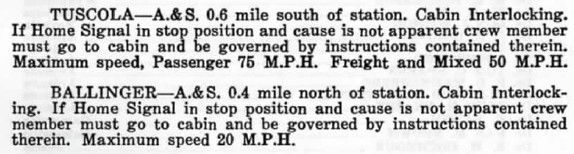
| Right:
A Santa Fe Employee Timetable from April, 1964 contained this note about
the cabin interlockers at Tuscola and Ballinger. Later timetables show no indication
that either crossing was ever converted to an automatic interlocker. There was no
incentive for the A&S to seek to automate either interlocker because it
had relatively infrequent traffic over the line and its trains were
operating slowly near the crossings anyway due to the proximity of its depots and yards. The delay to stop
at the cabin did not substantially affect A&S operations. Santa Fe had
no incentive to automate either plant because its trains never
stopped unless the crossing was occupied, a situation that would be no
different with an automatic interlocker, a much more expensive plant to
maintain. |
 |
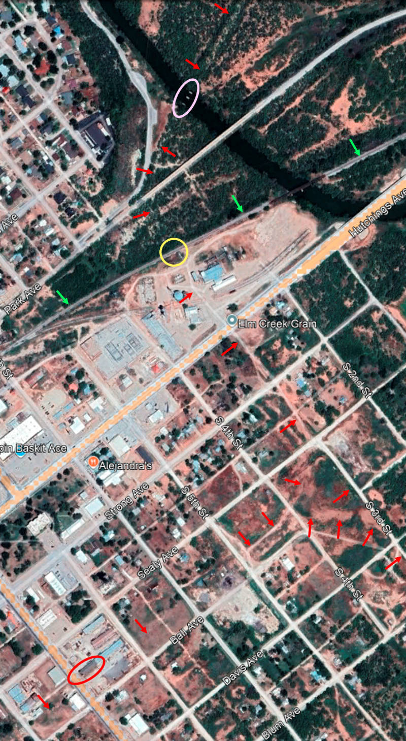 |
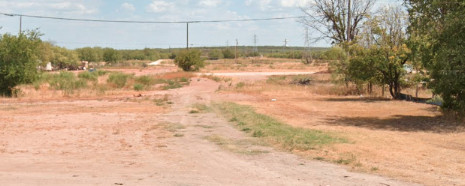
Left:
This 2024 Google Maps image has been annotated to show the path (red
arrows) of the A&S at Ballinger. It entered from the north on its
bridge (pink oval) over Elm Creek (below,
Jim King photo 2009 with the Park Avenue bridge in the background.)

The A&S then curved east to cross (yellow circle) the Santa Fe tracks (green
arrows) and continued down what is now S. 3rd Street (below),
which remains ill-defined as viewed southeast from Hutchings Ave. (Google
Street View, August 2023.)
The tracks continued along S. 3rd St., forming a wye where the track
curved to the southwest to parallel Ball Ave. This was the depot lead to
reach the A&S depot (red oval) which still stands.
This Google Street View image (below) looks north from S. 7th St. showing the long
(east) wall of the depot which faced the tracks.

Ballinger is
rare in that it had two stone depots that are both still standing. The Santa
Fe depot (below) sits
on the southeast side of the tracks at N. 7th St., off the left edge of
the image. (Jim King photo, 2009)
 |
In 1972, the sixteen miles of A&S track from
Ballinger to Winters was abandoned; the remaining 31 miles through Tuscola into Abilene survived until
1988. Though the train frequency is low, the GC&SF tracks through Ballinger are
still in operation, now owned by Texas Pacifico Transportation. To the west, the
line extends to San Angelo (GC&SF origin), and continues to the international
bridge at Presidio (KCM&O origin.) To the east, it goes to San Angelo
Junction (originally Coleman Junction) where it connects with
Burlington Northern Santa Fe (BNSF), the corporate successor resulting from Santa Fe's
merger with Burlington Northern in 1995. BNSF operates the former GC&SF / P&NT
Santa Fe main line.
 |
Left:
William Thompson provides this photo from the late 1980s showing him and his
fellow crewmembers about to cross the Santa Fe line at Tower 129 toward Abilene.
Since it was owned by the T&P, the A&S was absorbed into Missouri
Pacific (MP) when MP merged the T&P in 1976. MP had owned a controlling
interest in T&P stock since the 1930s, and the railroads had
collaborated closely for decades. In 1982, Union Pacific (UP) acquired MP
as a wholly-owned subsidiary which continued to operate under its own
name until the late 1990s. On the day pictured, MP had assigned UP
locomotive #2124 to work the A&S route.
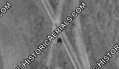
Above: This 1937
aerial image ((c)historicaerials.com) shows Tower 129 in the south
quadrant of the crossing casting a shadow to the north. A connecting
track is visible east of the diamond and it remains intact through 1966
imagery, and possibly as late as 1983. It would have supported movements
between Abilene and Brownwood, but its actual use is undetermined. |
The function of the connecting track at Tuscola is
undetermined, but it is interesting to speculate that it could have been used as
an alternate route to Fort Worth for the T&P if a major accident or bridge
outage curtailed use of the main line east of Abilene. Eastbound T&P traffic
toward Fort Worth could take the A&S at Abilene to Tuscola and use the connector
to switch to Santa Fe's tracks to Brownwood. From there, a direct line to Fort
Worth existed, owned by Santa Fe post-1937 (and by the Fort Worth & Rio Grande
before then.) The connector also could have served Santa Fe as a means of
exchanging northbound cars from Temple into Abilene, or moving southbound traffic out of Abilene to Temple and beyond. Santa Fe had
an exchange with the T&P at Tecific, but for Abilene traffic, it was only useful
for movements in the opposite direction, i.e. eastbound on the T&P into
Abilene, and westbound on the T&P out of Abilene.
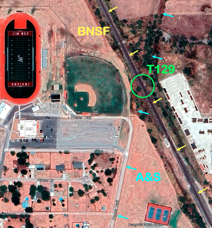
Right:
This recent Google Maps image of the Tuscola crossing shows its proximity to
the baseball stadium of nearby Jim Ned High School. The tracks are 450
ft. from home plate; a homerun could hit a passing train, but it would
take a major league slug! The A&S tracks would have been closer down the
right field line, but the stadium appears to have been built after the
A&S was
abandoned in 1988. The A&S ROW south of the crossing was paved to
become Pecos Trail, a road used for access to the parking lot for the
football stadium and baseball field.

Above: At the north
end of the A&S ROW on Pecos Trail, the BNSF tracks are visible at right,
angling toward the Tower 129 crossing directly ahead.
Below: At the south
end of Pecos Trail, the roadway ends at 8th St. but the ROW continues
straight. This straight section of A&S track was 3.7 miles
long (both images, Google Street View.)
 |
 |

Above: This Google Street View
from August, 2023 looks southeast from BNSF's Brown Ave. grade crossing at
Tuscola. The track at left is part of a siding approximately 5,700 ft. in
length. Historic aerial imagery shows that the switch in the foreground was
actually Santa Fe's depot lead. The station was trackside a thousand feet from
this switch, sitting between the main line and the depot lead which passed on
the "street side" of the station. The depot lead continued farther south and
reconnected to the main line about 1,800 feet from this switch, as it does so
today. The Santa Fe depot is visible in 1958 aerial imagery, but is no longer
present in 1966 imagery.