Texas Railroad History - Towers 33,
156 & 169 - Bay City and Allenhurst
Three Crossings of the Cane Belt Railroad, the New York,
Texas & Mexico Railway and the St. Louis, Brownsville and Mexico Railway
Special thanks to Julian Erceg
and Carl Codney for
information about the Bay City Area interlockers.
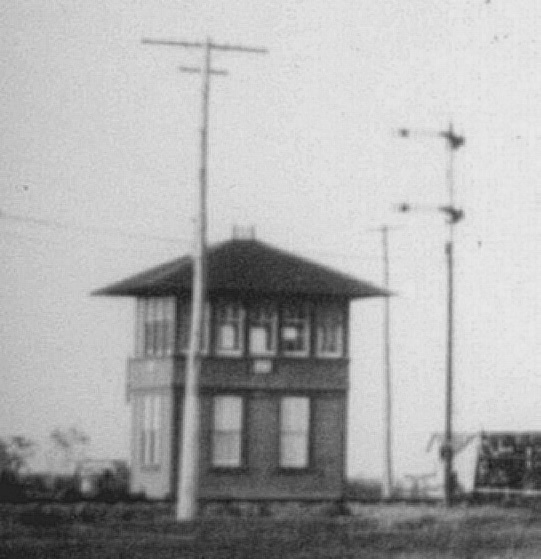
Above Left: Tower 33, date unknown (Matagorda County Historical Museum
collection) Above Right:
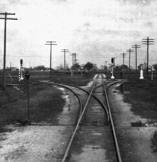
Looking east along the St. Louis, Brownsville & Mexico (SLB&M) Railway at its
crossing of the Cane Belt Railroad, John W. Barriger III snapped this photo
sometime in the 1930s from the rear of his business car as his train passed
through Bay City heading timetable south toward the Rio Grande Valley. This
crossing was interlocked as Tower 169 in June, 1931, but there was no tower.
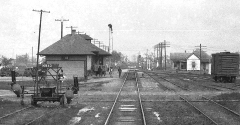
Below: Instead of a
manned structure, the Tower 169 interlocker controls were located in the nearby SLB&M depot
a short distance west of the diamond.
The depot (built in 1905) appears trackside in this photo Barriger most likely took a
few seconds after the one above, with the Cane Belt crossing now a bit farther
in the distance.
Below: Here's the same view
roughly
85 years later (2019). Population brings trees! The depot is now
owned by the city. (Google Street View)
Bay City was founded in 1894 by David Swickheimer, a
land developer and promoter who believed the location near the Colorado River
was ideal for a town. Promotion included publication of a
local newspaper, the Bay City Breeze, before the first buildings in town
had been built. The newspaper aggressively promoted the town throughout
Matagorda County. When Bay City won the election in September, 1894 to be named county seat of Matagorda
County, the newspaper article celebrating the victory mentioned
that the town did not yet exist. Bay City quickly developed into
a major rail junction with three railroads arriving within
ten years.
The first was the Cane Belt Railroad in 1901. It had been
chartered in 1898 to acquire a mile of
track from the Galveston, Harrisburg and San Antonio (GH&SA) main line at
Eagle
Lake south to a sugar refinery at Lakeside. From there, ten additional
miles south to Bonus were built to serve a sugar cane plantation. The Cane Belt continued
building south, reaching Wharton in 1900 and Bay City in 1901. Southward
construction resumed in 1903 with a line from Bay City to Matagorda. That year,
the Cane
Belt was purchased by the Atchison, Topeka & Santa Fe Railway (ATSF) and then leased
(in 1905) to a subsidiary, the Gulf, Colorado & Santa Fe (GC&SF) Railway.
The Cane Belt continued to operate under its own name until it was formally
merged into the GC&SF in 1948. The GC&SF was absorbed into its parent ATSF in 1965.
The second railroad was the New York, Texas & Mexican (NYT&M) Railway as they
constructed a round-about branch line from Wharton to Palacios via Bay City,
serving agricultural and mineral interests in the lower Colorado River
valley. The NYT&M had been founded in 1881 as part of a grand plan to build from
New York City to Mexico City. Its initial construction was 91 miles from
Rosenberg to Victoria
via Wharton. Shortly thereafter, it was acquired by Southern Pacific (SP) but
continued to operate under its own name. In 1900, the NYT&M began construction of
a branch south from Wharton, reaching Van Vleck in 1901. Railroad Commission
of Texas (RCT) documentation states that the tracks from Van Vleck through Bay
City were built as part of a continuation of this branch to Palacios in 1903,
but other documentation suggests the construction actually passed through Bay
City in 1902. RCT records also list 1903 as the year that the NYT&M built a
branch southeast from Van Vleck to Hawkinsville. This branch is significant only
because the the third railroad into
Bay City built across it at a location that was interlocked after a delay of
more than two decades.
That third railroad into Bay City was the St. Louis, Brownsville and Mexico (SLB&M) Railway chartered in 1903 to build from
Algoa (near Houston) to the Rio Grande Valley.
Construction proceeded north and south from Robstown, passing through Bay City
in 1906. In 1910, the SLB&M became owned by the St. Louis San Francisco
("Frisco") Railway and was assigned to a Frisco subsidiary, the New Orleans,
Texas & Mexico (NOT&M) Railroad. In 1916, a new
independent company, the New Orleans, Texas & Mexico (NOT&M)
Railway, was established to acquire several
Frisco railroad properties, including the SLB&M and the prior NOT&M "Railroad".
Collectively these railroads had been known as the Gulf Coast Lines, and they
retained that moniker. In 1925, the NOT&M was purchased by the Missouri Pacific
(MP) Railroad. Under MP ownership, the SLB&M continued to operate under its own
name until 1956 when it was merged into MP. MP was then acquired by Union Pacific (UP) in 1982.
Although the NYT&M and Cane Belt lines were vaguely parallel, both coming south
from Wharton, they crossed at a right angle north of the center of Bay City
where the NYT&M right-of-way (ROW) was temporarily on an east/west heading. The
first interlocker in Bay City, Tower 33, was commissioned for service at this
crossing by RCT on February 18, 1904, as a 2-story manned structure with a
21-function electrical interlocker manufactured by the Taylor Signal Company.
Eighteen months later, SP merged the NYT&M into another SP railroad, the GH&SA,
and in 1934, the GH&SA was merged into SP's operating subsidiary for Texas and Louisiana, the Texas & New Orleans (T&NO)
Railway.
Julian Erceg describes the Tower 33 crossing...
The tower was owned,
operated and maintained by the
T&NO, with maintenance costs split 50/50 between the T&NO
and the Cane Belt. In 1943, the tower was upgraded to meet ICC
code, with changes made to the signal types (semaphore to
color light on the Cane Belt for the southbound home signal) and
signal placement. The ownership changed at that time as well to
reflect the amount invested by each railroad to bring the tower
up to code. More interestingly, the towerman worked only one
trick (first shift, Monday-Saturday), and occasionally would be
called to line up signals at night and on Sunday. The first three
switches south of the diamond on the Cane Belt were interlocked,
switches for the passing siding, interchange track, and a track
leading to industry/yard tracks. Here is the General Notice posted
by the GC&SF headquarters in Galveston for the change to the signals on the Cane Belt:
General Notice #227
Bay City Interlocker #33
Galveston, August 16, 1943
ALL TRAIN AND ENGINEMEN:
Effective this date, home interlocking signals governing movement
over T&NO Railroad crossing, Bay City, have been changed to
color light type signals and relocated 250 ft north and 394 feet south of the
crossing, respectively. The semaphore dwarf signals on north end siding, T&NO
transfer[,] and industry track have
been relocated approximately 3 feet from the derails protecting
movements from these tracks to the main track.
The last paragraph of Special Rule 24, page 3, Timetable No.
147 reading:
"General Rule 780. Two arm semaphore signal just south of T&NO
crossing at Bay City. Top arm governs southward movements on main
track. Lower arm governs movements to north end of siding and
T&NO transfer" is hereby cancelled and the following
will govern:
General Rule 780. Three position searchlight type
color signal just south of T&NO RR crossing Bay City. Proceed (green) indication
governs southward movement on main track. Restricted (yellow) governs movements
to north end of siding, T&NO transfer[,] and industry track.
It is interesting that they replaced a two-armed semaphore,
standard for signals governing movements to both the main track
and siding tracks, with a one head signal using indications in
non-standard ways. One other detail. The Cane Belt south of Bay City is still
used [~ 2002] by BNSF to reach the Equistar plant south of Wadsworth.
The power for the turn is kept a few blocks north of the former
MP crossing. It runs during the day. North of Bay City the track
is used for a couple miles out of town to store the Equistar EQUX
covered hoppers. I'm not sure if they are empty or loaded, stored
in a one track Storage In Transit (SIT) yard.
 |
Left: The "T&NO
Victoria Division Time Table" effective June 5, 1938 specified two
whistle codes for signaling the Tower 33 operator. It also defined the
schedule for signal alignments and associated procedures when there was
no tower operator on duty. Elsewhere, the timetable stated the tower was manned
"Daily Except Sunday and Legal Holidays" from 8:30 to 11:45 AM and
from 12:45
to 5:30 PM. The December, 1947 timetable listed the staffed hours as 9:00 AM to 6:00 PM. In the December, 1949 timetable, the Tower 33
interlocker was identified as "Automatic", i.e. no longer manned at
all. Whether the tower structure still stood as of that date is unknown,
and the ultimate fate of the tower has not been determined. |
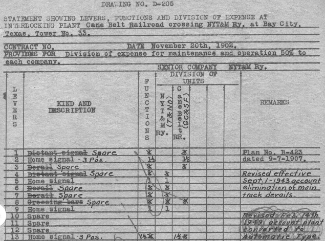
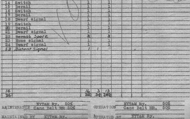
Above: T&NO's one-page
interlocker summary for Tower 33 (from the Carl Codney collection) is split into
two scans, the top
(left) and bottom (right)
of the document.
Note that the original contract date was November 20, 1902, only a month before
RCT (pursuant to recently established state law) published its first list of grade crossings
to be interlocked. The
NYT&M/Cane Belt crossing was the final entry on that list. Although the Cane Belt built
through Bay City first, the railroads agreed that NYT&M would be listed as the
"SENIOR COMPANY". With NYT&M (or more likely, SP Engineering) taking the lead, the
interlocker was commissioned 15 months after the contract date. The document
shows that NYT&M was responsible for tower operations and maintenance, with
costs split evenly by the railroads. It also records the design date as
September 7, 1907, three and a half years after the interlocker began operation.
There are no details of what, if anything, changed during that period, and it
could have been merely a formal release of "as built" updates to SP's
engineering drawings. The document was revised "effective September 1, 1943" to show
"elimination of
main track derails", an action approved by the Interstate
Commerce Commission on August 11, 1942. The final revision to the document was a notation
(which someone tried to scratch out with a pencil) stating "Revised Feb.
14th 1949 account plant converted to Automatic Type." Other
documentation (also provided by Carl Codney) shows that in anticipation of
installing an automatic interlocker, a new plan was initiated on January 8,
1948 and added to the contract on July 9, 1948. This plan gave each railroad
home signals for the automatic interlocker in both directions. The amended
contract became effective on the transition date, February 14, 1949. Only five
years later, the automatic interlocking was "Placed out of service 12:01 PM
April 12, 1954". According to T&NO's May 1, 1955 timetable, the crossing had
become a manual gate. A corresponding 1959 Santa Fe timetable states that all
GC&SF trains must stop at the T&NO crossing in Bay City. Hence, the gate was
normally closed against the Cane Belt tracks (if all trains on both lines had to
stop, the gate would serve no purpose.)
T&NO's service to Palacios
on the former NYT&M tracks from Bay City
declined significantly in the 1930s. In 1933, state law changed to allow RCT to
grant waivers to railroads from the minimum service requirement of "a train a
day" on every branch line. T&NO's petition to reduce service to
Palacios to one train per week was granted in March, 1938. Daily mixed train
service to Palacios was replaced by weekly service plus "on demand" service if a
carload of freight was offered by a shipper on the line. Although service may
have varied over the years, SP was able to avoid abandoning the Bay City -
Palacios line until 1985. Two years later, SP
abandoned the tracks east from Bay City to Newgulf, the
non-interlocked junction where Santa Fe's "Hall District" from Cane
Junction to Thompsons crossed the NYT&M (as explained further below.) Thus,
by 1987, SP no longer served Bay City.
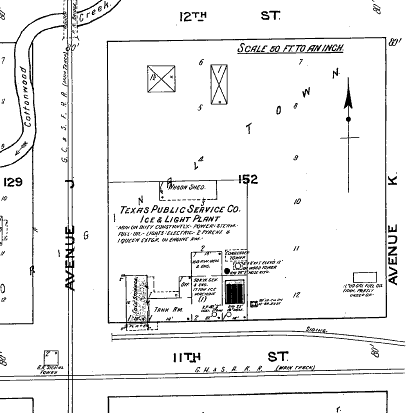
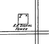

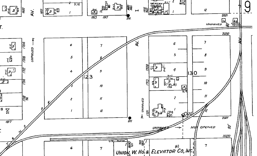
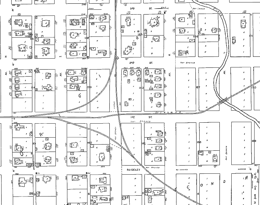
Above Left: The 1917 Sanborn Fire Insurance Map of Bay
City shows Tower 33 located in the northwest quadrant of the intersection of 11th
St. and Avenue J. Near the tower, neither was an actual street, merely a
railroad ROW, and they remain unpaved today. Magnification
(above center)
confirms Tower 33 was a two-story "R.R. Signal Tower".
Above Right: Immediately west
of where the tower sat, the NYT&M slanted southwest to 9th Street and then curved back to a
westward heading. Like 11th Street, 9th Street was only a railroad ROW, at least
on the west side of town, and it remains unpaved today. West of Bay City, the
tracks turned south to Blessing and Palacios. Below Left:
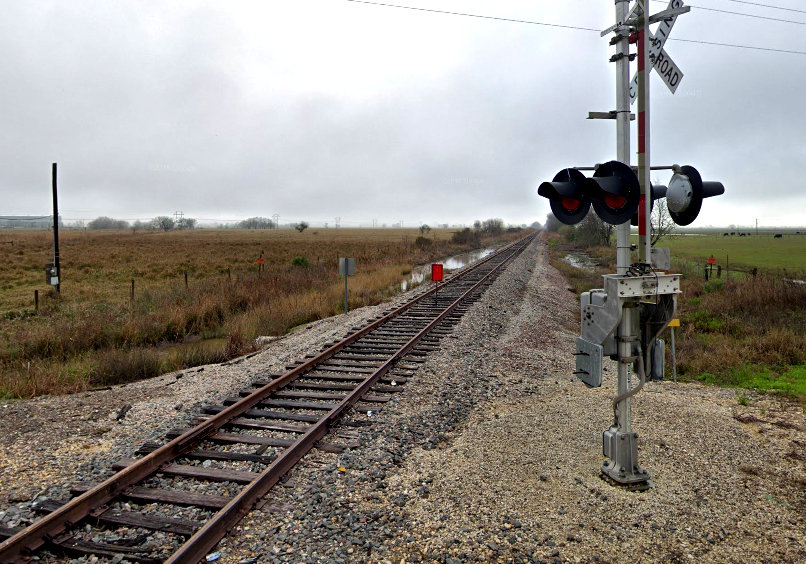
The Cane Belt tracks remain intact through Bay City. North of Bay City, they continue past Farm Road 3156, but a red sign
indicates they are out of service north of the grade crossing as of 2019.
Below Right: The Cane Belt tracks
continue 13 miles south of Bay City past Wadsworth to serve the Equistar
polyethylene resin plant.
Above: As of 1942, the Sanborn
map description of Tower 33 had changed to "Switch Tower" and a one-story cabin had been added
nearby. A connecting track facilitated T&NO - Cane Belt interchanges.
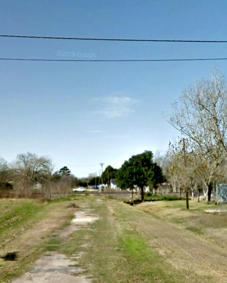
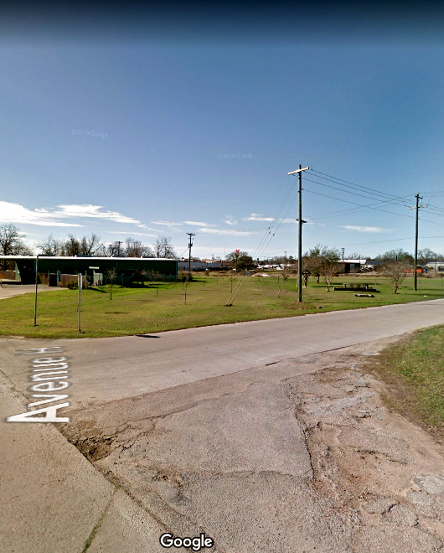
Below: These Google Street
View images from 2013 show traces of the NYT&M. At
left, looking west from Ave. K along the NYT&M ROW, the
Cane Belt tracks can be seen intact running north/south in the distance. At
right, the view to the
southwest at the intersection of 10th St. and Ave. H shows the NYT&M ROW as it
angled toward 9th St. where it then turned back to the right on a due west
heading.
Like the NYT&M, the SLB&M also ran through Bay City on an
east/west heading, crossing the Cane Belt at a right angle on the south side of
town, three quarters of a mile south of Tower 33. This crossing was not
controlled
until the Tower 169 interlocker was established there in 1931. Julian Erceg explains why...
"As the first railroad to arrive in Bay City, the Cane Belt
held the crossing contract with the SLB&M giving the Cane
Belt the right to force SLB&M to build a tower at the crossing
if the Cane Belt ever desired one. In 1918, Texas Gulf Sulphur Co.
began mining sulfur near the Cane Belt station
of Gulf Hill, around five miles north of Matagorda. There were
daily extra sulfur trains from Matagorda to Galveston passing
through Bay City. Trains would take fuel at Lane City [north of
Bay City], and would have to run to Matagorda(and back.) When the Hall District
was constructed from Cane Jct. to Thompsons in 1931, the
benefit was that sulfur trains from Gulf Hill to Galveston saved a considerable
amount of mileage by being able to avoid going all the way up to
Sealy. Fuel oil
facilities had to be constructed in Matagorda, built between November, 1931 and
January, 1932, because
the trains no longer passed through Lane City to get fuel. However,
this was short lived, as the last sulfur from Gulf Hill was 8
carloads in June, 1938.
By 1930, the SLB&M was running many trains a day across
the diamond at Bay City and desired protection to eliminate the
time consuming stops for each train at the diamond. The Cane Belt,
generally running only its scheduled mixed train 115/116 and a
sulfur extra from Gulf Hill each day, didn't really need protection
for the diamond. So, to avoid the cost of maintaining and staffing
a tower for the Cane Belt, while still allowing the crossing to
be protected for the SLB&M, it was negotiated to install
a manual interlocking plant and have it be controlled by the operator
in the SLB&M depot a few blocks west. If Cane Belt trains
were ever to become regularly delayed waiting at the SLB&M-controlled
interlocking, the Cane Belt held the option of forcing the SLB&M
to build a tower, but this never happened. Signals and circuiting
were installed, with approach lit color light signals governing
movements on the SLB&M, and approach lit electric semaphores
on the Cane Belt. Color light distant signals were located 3000'
in advance of the crossing in each direction for SLB&M trains,
with 2000' annunciator circuits extending past the distant signals.
On the Cane Belt, an approach lit distant electric semaphore was
placed 3000' south of the diamond, but no distant signal was used
for southbound trains [southbound Cane Belt trains had already slowed or
stopped for Tower 33]. A 2000' annunciator circuit extended south
of the distant signal, and a 3440' annunciator signal extended
north of the crossing for Cane Belt trains. Bulletin
379 issued for Santa Fe trains, June 24, 1931 reads..."
SUBJECT: Interlocked crossing - SLB&M Crossing - Bay City
ALL GC&SF TRAIN AND ENGINEMEN:
Effective 9:01 AM, June 29, 1931, the SLB&M railroad crossing
at Bay City, Mile Post 69.0, will be protected by standard home
interlocking signals, controlled from the SLB&M telegraph
office at Bay City, and a standard automatic distant signal governing
northbound trains approximately 3000' south of this crossing.
That part of the current time table, under Rule 17, regarding
all trains and engines to stop at the grade crossing at Bay City,
M.P. 69.0, is hereby cancelled and trains approaching the crossing
and finding the signals indicating clear or proceed may proceed
over the crossing without stopping. Trains or engines desiring
to enter the SLB&M main track through transfer track will
be governed by signal governing such movements on this track.
Trainmen must communicate with SLB&M Operator by telephone
before reversing switch on SLB&M main line, when "S"
indicates switch may be reversed and if signal then indicates
"yellow", train may proceed. Obtaining indication on
the "S" does not permit train movement, but allows only
the operation of the SLB&M main line switch. Train movements
will be governed by signal indication. Trains or engines must
not exceed a speed of 25 miles per hour at any time between home
signals. Automatic speed recorders register speed of all trains
as required by the Texas Railroad Commission. Rules in the Book
of Rules and Regulations of the Operating Department will govern.
A telephone will be located near water crane at passenger depot
and another telephone will be located on home signal at the north
end of the wye. Southward Santa Fe trains arriving in Bay City
and finding it necessary to leave any part of their train in main
track while doing station work will promptly notify SLB&M
Operator by telephone that they have work to do at station and
conductor will notify Operator by telephone when ready to pass
over crossing. Please be governed accordingly.
A.G. Fish, Trainmaster
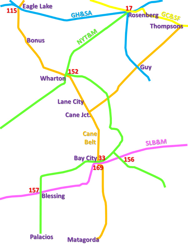 |
Left:
This Area Map shows the main rail lines in the vicinity of Bay City with
tower numbers in red (not all railroads shown). About six miles east of
the Tower 169 crossing, the SLB&M crossed the NYT&M branch that
ran from Van Vleck to
Hawkinsville. This branch had been built in 1903, before the SLB&M came
through the area, but it was not interlocked until August 2, 1929 when
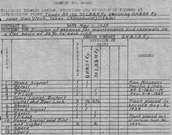
Tower 156 was approved as a 12-function mechanical cabin. Officially,
RCT recorded Tower 156's location as
Allenhurst (a tiny unincorporated community), but SP documentation (below) referenced it as "near Van Vleck (Allenhurst)". (Carl Codney collection)
<additional blank lines...note that the "10"
below in the first column appears to be a stray mark>
 |
SP's documentation for Tower 156 is
interesting because it confirms that this plant may have had the shortest active
life among all of the numbered interlockers in RCT's system. The interlocker was
"Placed out of service Sept. 26, 1932" just three years and two months
after it was commissioned. The decommissioning resulted from SP's decision to
abandon the branch to Hawkinsville in 1932. During its brief existence, it was a mechanical
interlocker with controls located in a trackside cabin. Cabin interlockers were
unmanned, used where a busy line (here, the SLB&M) and a lightly
used line (SP) crossed. For Tower 156, the controls were operated by SP train crews
and the signals would be set to allow unrestricted movement on the SLB&M. When
an SP train needed to cross, an SP crewmember would enter the cabin,
set the signals to allow his train's movement over the diamond (thereby
signaling a STOP condition on the SLB&M), and then reset the signals when the
crossing was complete. SLB&M trains would always see clear signals unless an
SLB&M train happened to approach the crossing while SP was using it. When
Tower 156 first appeared in RCT's annual report, it was listed as having 12
functions, but the documentation above shows 13 functions. The extra function, undoubtedly the door lock, was incorporated after
the initial commissioning date. Note also that by the time Tower 156 was
commissioned, the NYT&M had been absorbed into the GH&SA, which was listed in
RCT records as the official participating railroad (along with the SLB&M.) Like
the arrangement with the Cane Belt for Tower 33, SP and MP agreed to a flat
50/50 share on maintenance expenses, disregarding the function weighting.
It would be easy to argue that the Tower 156 crossing was interlocked a
couple of years before the Tower 169 crossing because the time and energy
penalty for stopping was more substantial -- there was often a reason for SLB&M
trains to stop in Bay City anyway, but there was virtually no reason to stop at
Allenhurst (nor 1.6 miles west of there, where the crossing was actually
located.) But in reality, Tower 156 was merely part of a larger, concerted
effort on the part of SLB&M to interlock all of their "cabin-eligible" crossings
during the first nine months of 1929. Between January 3, 1929 (Tower
145 at Edinburg) and October 1, 1929 (Tower 158
at Placedo), the SLB&M established all nine of the cabin interlockers it would
ever have. Besides Tower 156, the other six were at
Edcouch, Lantana,
Alsonia, Rosita,
Angleton and Blessing. Whether this was just
good railroading or a response to pressure from RCT is unknown. The SLB&M did
have other interlockers, but Harlingen,
Victoria and Algoa
were manned (Algoa was decommissioned in 1913), and
Sinton was automatic. (Robstown and
Bloomington were also automatic and were listed as
MP instead of SLB&M.)
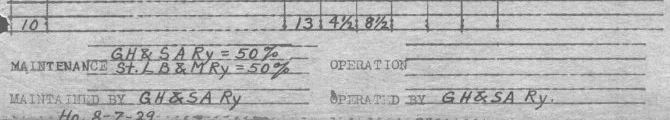
Below Left: This snippet from a 1952 USGS topographic
map shows the "Old Railroad Grade" of the NYT&M crossing the MP tracks,
providing a precise location for Tower 156.
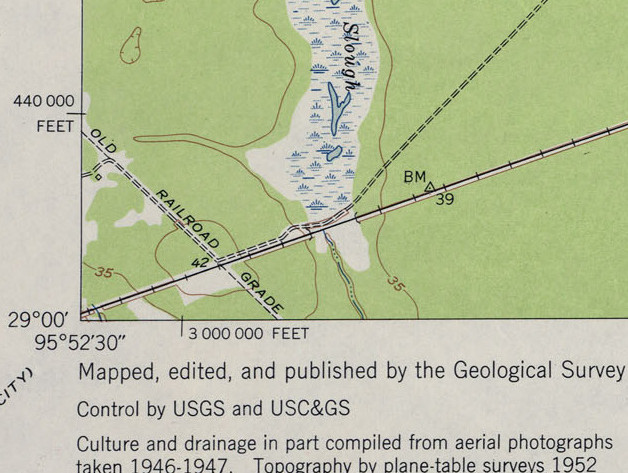
Below Right: This Google Earth satellite image from 2018 shows the
crossing location can still be spotted (right center), about 2,200 ft. east of the Farm Road 2540 grade crossing of the UP
tracks. From the center of Van Vleck, the NYT&M track ran southeast on a
straight line, reaching the Tower 156 crossing in about 1.6 miles. Allenhurst
was about 1.6 miles east of the crossing along the SLB&M, so the official
location of Tower 156 could just as easily been specified as Van Vleck.
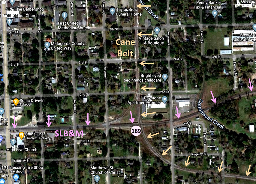
Above: The 1942 Sanborn map shows the Tower
169 crossing located at Avenue J and 1st St.
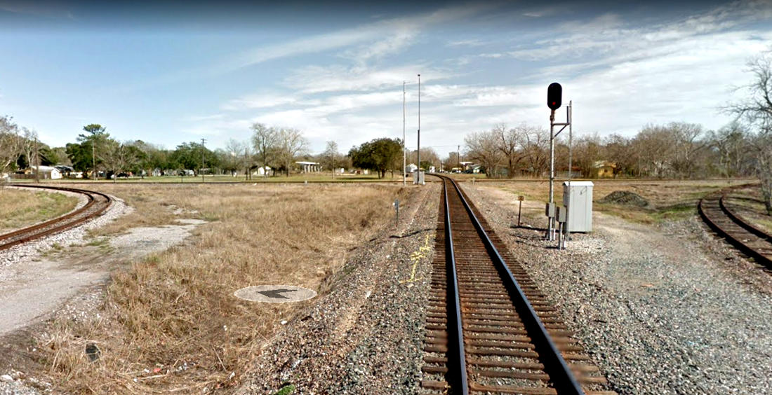
Below: a recent satellite image of the Tower 169 junction
The Cane Belt tracks
were ultimately inherited by Burlington Northern Santa Fe (BNSF) resulting from the
Burlington Northern merger with ATSF. South of the Equistar plant near
Wadsworth, the eight miles of track to Matagorda was abandoned in 1990. To the
north, the Cane Belt tracks remain intact approximately 2.5 miles north of the
Tower 33 crossing, but are out of service a short distance beyond the FM 3156
grade crossing. Farther north, the tracks were abandoned by BNSF in 2004. BNSF
now owns approximately 16 miles of track from south of Wadsworth to the FM
3156 grade crossing north of Bay City. They reach these tracks using rights on UP's
former SLB&M route through the Tower 169 junction. This line remains very active
as the major rail line serving coastal south Texas and the Rio Grande Valley.
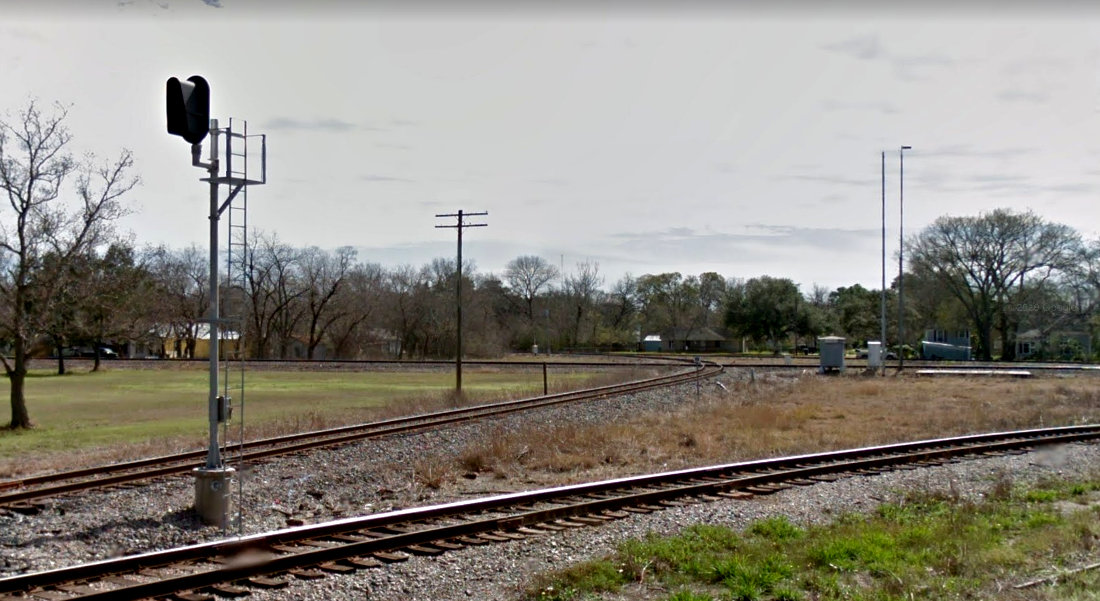
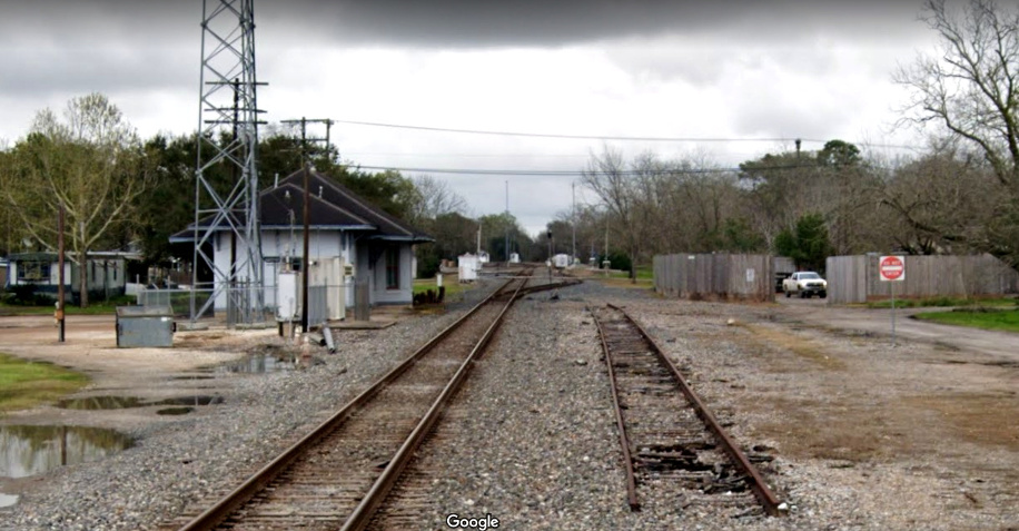
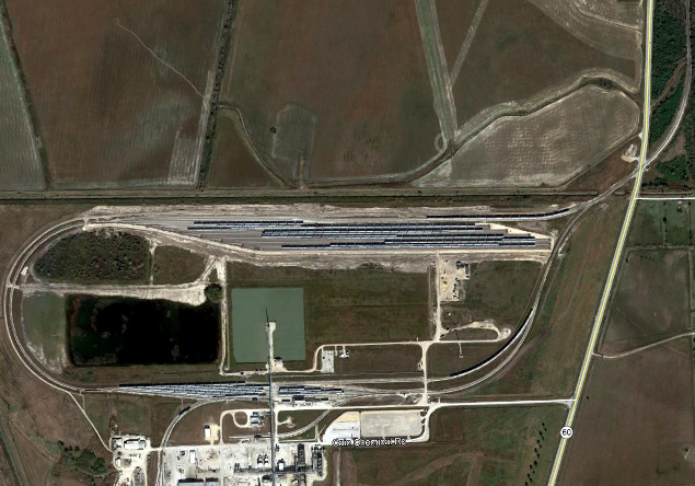
Above: This 2013 Google Street
View faces southeast at the Tower 169 junction. The track in the foreground is
the northwest quadrant connector. UP's ex-SLB&M main line runs horizontally
across the middle of the image while the BNSF ex-Cane Belt line on the other
side of the nearby block light crosses UP's tracks and immediately curves to the
southeast. The southwest quadrant connector is barely visible beyond UP's main.
Below: This 2013 Google Street
View looks east along the UP main track at Tower 169 with the former Cane Belt
main line crossing the diamond ahead. The northwest (left) and southwest (right)
quadrant connecting tracks are also visible.