Texas Railroad History - Towers 158 and 215 - Placedo
and Bloomington
Two Crossings of the St. Louis, Brownsville & Mexico Railway
Southeast of Victoria

Above: Rail executive John W
Barriger III took this photo of the crossing in Placedo from the rear platform
of his business car as his train sped south toward Harlingen on tracks of the St.
Louis, Brownsville & Mexico (SLB&M) Railway.
Barriger's view is to the northeast toward Blessing
and Bay City during a trip most likely taken in the mid to late 1930s. His car has just passed the SLB&M depot and crossed over
tracks of the
Texas & New Orleans (T&NO) Railroad, a Southern Pacific (SP) subsidiary. The tracks had transitioned to T&NO
ownership when another SP subsidiary, the Galveston, Harrisburg & San Antonio
(GH&SA) Railway, was folded into the T&NO by lease (1927) and merger (1934.)
From Placedo, SP's line ran to Victoria (left) and
Port Lavaca (right). The SP depot can be seen trackside northwest (left) of the SLB&M
depot. Both depots appear
to be boarded up, for unknown reasons, perhaps an approaching tropical storm. The tall
pole to the right of the crossing was a gatepost that had been used during an
earlier time when the crossing was gated. (John W Barriger
III National Railroad Library)
 |
Left:
A 1919 Employee Timetable (ETT) issued for the GH&SA by the U. S.
Railroad Administration (which exercised Federal
control of the railroads during World War I) incorporates this passage
to explain the presence of gates at non-interlocked crossings (which in 1919 included Placedo) and how the
gates should be operated. |
Despite the difference in spelling, the town of Placedo was named for Placido
Benavides, a Mexican citizen and area rancher who had a prominent role in
resisting Mexican forces during the early stages of the Texas Revolution. The
community predated the arrival of the railroad just as the Civil War began.
The charter for the San Antonio and Mexican Gulf (SA&MG) Railroad had been
issued ten years before the War when citizens of Port Lavaca decided to grapple
with the difficulty of moving freight between their port and the population
centers further inland. With an immediate objective of reaching Victoria, the
first five miles out of Port Lavaca was completed in either 1857 or 1858. The remaining 23 miles to Victoria was opened in 1861.
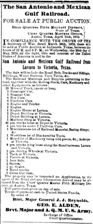
The SA&MG did not survive the War intact, but it was rebuilt by the Federal
government afterward. When the construction debt owed to the government could not be repaid, the line
went into bankruptcy and was sold at auction to Charles Morgan in 1870.
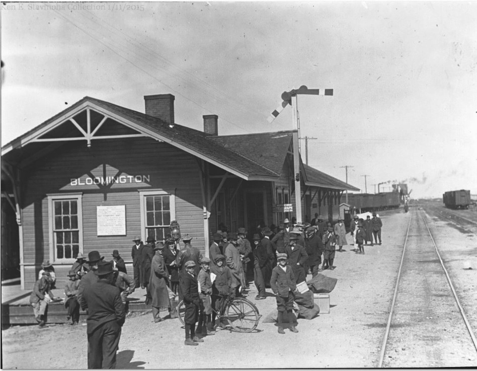
Below Left:
After taking the photo in Placedo, Barriger passed through Bloomington, five
miles farther south. But if he photographed the crossing there, it has not been
published by the John W Barriger III National Railroad Library. Ken Stavinoha
provides this undated photo of the SLB&M depot in Bloomington (photographer
unknown.)
Below Right: An 1870 edition
of the American Railroad Journal
published an advertisement for the public auction of the SA&MG's assets. Note
that the sale includes "1 Worthless lot of Blacksmiths Tools".
Charles Morgan operated a steamship line into the port of
Indianola, near Port Lavaca, and he also purchased the 15-mile Indianola
Railroad that ran from Indianola to a connection with the SA&MG at Clark's
Station, about six miles out of Port Lavaca. Morgan renamed his combined
railroad the Gulf, Western Texas & Pacific (GWT&P) Railroad. In 1873, he
extended the tracks from Victoria north to Cuero, planning to continue to
San Antonio.
But major hurricanes in September, 1875 and August, 1886, inflicted severe
damage on the GWT&P, both physically and financially. The Indianola branch was
abandoned, but the Port Lavaca line was repaired; service to Cuero
resumed in 1887. Southern Pacific (SP) gained control of the GWT&P
in 1882, a result of the settlement of Morgan's estate after his death in 1878.
In 1905, SP merged the GWT&P into the Galveston, Harrisburg & San Antonio
(GH&SA) Railway, a major SP subsidiary operating in south Texas between
El Paso and Houston.
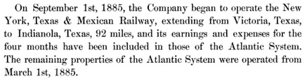 |
Left:
SP's 1885 Annual Report notes that it had begun to operate the rail
line from Victoria to Indianola, but
mistakenly conflates two separate activities: 1) acquisition of the New
York, Texas & Mexican (NYT&M) Railway and its 92-mile main line between
Rosenberg and Victoria, and 2) lease of the
GWT&P line from Victoria to Indianola, which was listed elsewhere as a
separate 66-mile operation in a table of SP's Atlantic System mileage.
Only a few months after this Report was published, the great hurricane
of August 20, 1886 would wipe out the town of Indianola, which was
abandoned. The GWT&P was then rebuilt into Port Lavaca from Clark's Station
using the original grade which had been
abandoned after the 1875 hurricane. |
The second railroad into Placedo was the St.
Louis, Brownsville & Mexico (SLB&M) Railway. The SLB&M was the first of the
Gulf
Coast Lines (GCL), a marketing term applied to a group of railroads backed financially by
the St. Louis Trust Company
and managed cooperatively by the St. Louis & San Francisco ("Frisco") Railroad.
The Frisco's Chairman, B. F. Yoakum, was a native Texan and long time Texas
railroader. It was his idea to create the GCL to build or buy railroads and
weave them into a system to compete directly with SP between
Houston and New Orleans. Yoakum elected to do this off the Frisco's books, engaging
the St. Louis Trust Co. to manage a financial syndicate and employing Frisco executives
to direct operations of the various GCL railroads. In 1903, Yoakum expanded his
GCL concept when he announced plans for
the first GCL railroad, the newly chartered
SLB&M. It would build the first line into the Lower Rio Grande Valley, which did not yet
have a connection to the national rail network.
Yoakum installed his former boss, Uriah
Lott, as SLB&M President. Lott had been the founder, promoter and President of the San
Antonio & Aransas Pass (SA&AP) Railway, and he had hired Yoakum in 1886 to be
SA&AP's traffic manager. Lott was so enamored with the young Yoakum's skills
that he named the town of Yoakum for him. By 1889, Yoakum had risen into SA&AP's
senior executive ranks as General Manager. He then became one of two
court-appointed Receivers assigned to oversee SA&AP's bankruptcy, which
commenced in July, 1890 and ended two years later. After
his service as Receiver, Yoakum took an executive position
with the Gulf, Colorado & Santa Fe (GC&SF) Railway and then
moved on to the Frisco in 1897. As Yoakum was rising in the railroad world,
Uriah Lott was mostly spinning his wheels. His passion was building railroads;
he'd built two of them successfully. Prior to building the SA&AP, Lott had built
the Corpus Christi, San Diego and Rio Grande (CCSD&RG) Narrow Gauge Railroad
which later became known as the Texas Mexican (TexMex) Railway. In the summer of 1902, Lott traveled to St.
Louis to convince Yoakum to build to the Valley. Yoakum was initially
dismissive, but he sent Lott back to Texas to run a new survey. In early 1903,
the news became public; Yoakum was planning a
Brownsville - Houston line.
Construction commenced south from
Robstown in August,
1903, and the line to Brownsville was finished in June, 1904. Yoakum's ultimate
goal was a line to Houston, so construction resumed north from Robstown in 1905,
passing through Placedo in 1906. A 1901 state law had authorized the Railroad
Commission of Texas (RCT) to require interlocker installations
at busy rail crossings, but RCT did not issue an order for the
Placedo crossing. Instead, a crossing gate was installed, probably as soon as
the SLB&M had crossed SP's tracks. The railroads may have been able to convince
RCT that a gate was a satisfactory safety measure because the crossing was very
close to both depots. Since virtually all trains were stopping at the depot anyway,
there was negligible delay in also stopping for the adjacent crossing as required by
state law for non-interlocked crossings. Interlockers were designed to allow
trains to maintain speed over the diamond, but trains stopping at nearby depots
weren't operating at track speed.
The SLB&M completed its northward construction as far as
Algoa, 25 miles south of Houston, in 1906. Algoa was
on Santa Fe's main line between Galveston
and Temple, and a nearby Santa Fe branch
from Alvin served downtown Houston. The
Galveston Tribune of March 12, 1906
reported that the first SLB&M train to Galveston from Brownsville would
be arriving later that day. This was, however, a one time special train, not the start of
regular service. The SLB&M had already determined that the grade,
ballast and bridge construction between Bay
City and Algoa -- a sixty-mile stretch through the Brazos River
bottomlands -- was insufficiently engineered to withstand the rainy
season. Significant drainage mitigation and track reconstruction
projects had to be undertaken. Another special excursion train ran from
Brownsville to Galveston on August 14, 1907, seventeen months after the
first one (it had been so long that newspapers reported it as "the first
train", completely forgetting the earlier one!)
The August excursion was a precursor to regular service between Brownsville and Algoa.
On September 9, 1907, the SLB&M announced a regular schedule between Bay
City and Algoa, indicating that the track construction and drainage
problems had been solved. The schedule was subsequently revised out of
Brownsville to match the Bay City schedule, enabling single train
service between Brownsville and Algoa. Passengers continued their
journey by switching to (or from) Santa Fe trains at Algoa. About six months later, Yoakum was able to negotiate rights
for the SLB&M to
use Santa Fe's tracks from Algoa to Houston.
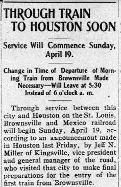
Right: The
Brownsville Daily Herald of April
13, 1908 reported that the SLB&M's Brownsville - Houston
passenger service would commence on April 19. |
 |
Five miles southwest of Placedo, the SLB&M built a
station in 1906 at a settlement known as Bloomington, named for the town in
Illinois which was the former home of nearby landowners. A Post Office opened in
1907. Bloomington was formally platted in 1910 (as was Placedo) the same year the SLB&M
built a 38-mile branch from Bloomington to Port O'Connor. This construction was
the culmination of a long effort to build rails to the coast southeast of
Victoria, an idea first proposed in the mid 1890s by T. M. O'Connor, a wealthy Victoria cattle rancher.
O'Connor owned 75,000 acres along the coast south of Indianola that he wanted to
develop into a hunting and fishing resort. Roads were non-existent; O'Connor
wanted rail service and he was willing to invest. A syndicate of bankers and
cattlemen in Victoria was formed to charter a railroad from Victoria to Port
O'Connor, the new name for the planned endpoint of the railroad. Supplies
brought in by barge enabled an office building to be built in Port O'Connor
along with a half-mile trestle into the bay to off-load rail materials to be
brought in by ship. The plan turned out to be too ambitious and poorly managed.
Grading was performed, but the funds dried up and the project came to a
standstill around 1901.
Several years later, another group acquired the
unfinished grade and set out to lay rails to Victoria. Despite spending $100,000
to repair the grade, only one mile of track was actually laid and the project
was abandoned. In 1909, Yoakum accepted an offer of $70,000 to be paid over ten
years for construction of a line from Victoria to Port O'Connor. Yoakum directed
the SLB&M to survey a different route with Bloomington as the starting point.
The line would run southeast to Seadrift and then due east to Port O'Connor.
Tracks reached Port O'Connor the following year. From Bloomington to Victoria,
the tracks were laid in 1912, finally giving T. M. O'Connor the railroad he had
envisioned twenty years earlier. Unfortunately, he did not live to see it,
having died in 1910.
|
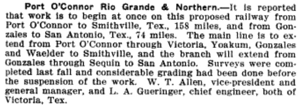
Right: The February 21, 1908 edition of
The Railway Age had this news item
regarding the planned reconstruction of the abandoned grade between Port
O'Connor and Victoria. The investors chartered their ambitious plan as
the Port O'Connor, Rio Grande & Northern Railway, but like many such
grandiose endeavors, this one also failed. The reference to
"...considerable grading had been done before the suspension of the
work." points to the original work in the late 1890s by T. M. O'Connor's
investment group. In his 1941
tome, A History of the Texas Railroads,
the dean of Texas railroad historians, S. G. Reed, states that the
original grading work had been completed all the way to Hallettsville!
That's
an enormous distance to grade without laying rail (because without rail,
work locomotives could not be used to support the effort.) Yet, despite
the existing grade and the expertise of Chief Engineer L. A. Gueringer
(who later became Chief Engineer of the Railroad Commission of Texas)
only a single mile of track was laid. |
 |
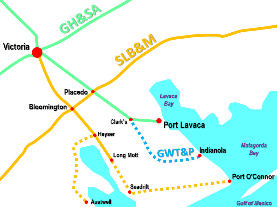 |
Left:
This map depicts the lines southeast of Victoria (not all
rail lines shown.)
Parallel lines to Victoria through Placedo and Bloomington have
survived to the present despite never being farther than five miles
apart. Both are now owned by Union Pacific (UP.) SP's lines in this area
were built by a mix of different companies. They were eventually
incorporated into the GH&SA which was later merged
into the T&NO. The T&NO operated until late 1961 when it was
dissolved and merged into SP. SP was acquired and merged by UP in 1996.
The SLB&M and the other GCL railroads were sold to the Frisco by the
St. Louis Trust Co. in 1910. When the Frisco entered receivership in
1913, the bankruptcy judge separated the GCL railroads from the Frisco
-- they were profitable on their own -- and consolidated them under a
new corporation headed by the New Orleans, Texas & Mexico (NOT&M)
Railroad, for which an updated charter was granted by the State of
Louisiana.
In 1915, the SLB&M built a 17-mile branch from Heyser to Tivoli and Austwell to reach
a large cotton farming area. The Austwell branch was abandoned in 1959.
The NOT&M was acquired by Missouri Pacific (MP)
in 1925, including all of the GCL railroads. In 1933, MP ceased
service to Port O'Connor. Its
population was only 300 and area farmers had begun using roads as the
primary option for moving their products. Livestock shipping by rail was
still good business, and the main loading point was at Lela Pens, a couple of miles east of
Seadrift. Lela Pens remained the terminus
of the Port O'Connor branch until MP abandoned the track south of Long Mott in 1969.
MP was acquired by UP in 1982. |
Long Mott is the site of a major
chemical plant, originally a Union Carbide Corp. (UCC) facility and now owned by Dow Chemical.
The plant
continues to produce chemicals and plastics for consumer products. The track from Bloomington runs along the west edge
of the facility, but the size of the plant and the volume of materials
shipped in and out motivated the addition of tracks on the east side of
the plant. In 2003, a lengthy spur was built to
connect those tracks to the former SP line
at Kamey near Clark's Station. This appears to have been the impetus for adding a
new connector at Placedo to allow movements to (northbound) and from
(southbound) the main line to Algoa. As
Bill Veerkamp explains, the UP / SP merger in 1996 provided both Kansas City Southern (KCS) and Burlington Northern Santa Fe (BNSF)
with trackage rights on UP rails
and
affected service to the chemical plant...
At the time of the UP/SP merger,
there were many conditions that the US Surface Transportation Board placed on
the merger based on comments from other concerned parties... and for the spur to
the former UCC facility there were conditions that both BNSF and UCC received.
Among many other trackage rights, BNSF and KCS got rights over UP lines down to
the valley. BNSF got (and uses) rights on the UP, Algoa to Placedo to Robstown.
... Also in the merger, UCC was granted the ability to have a second spur built
to the facility ... and BNSF was given the ability to get trackage rights over
the Port Lavaca branch. Dow purchased UCC, with the merger closing on 6 Feb
2001. The STB formally granted BNSF trackage rights from Placedo to Kamey on 6
Mar 2003. The spur went into service on Friday, 11 July 2003.
As steam locomotives began to operate over longer
distances at higher speeds, trains were able to bypass Placedo. The rules noted
earlier in the 1919 GH&SA ETT ("All trains must make the usual stops as
required by law, regardless of position of the gates.") changed in the
1920s to authorize trains to slow to a
restricted speed when approaching gated crossings, slow enough that they could
come to a complete stop before reaching the diamond if they saw that the
gate was positioned against them. Trains could otherwise continue over the diamond without stopping. This was
certainly better than coming to a
complete stop every time, but still not ideal on busier routes. The traffic
levels on the SLB&M coupled with infrequent traffic on SP's Victoria - Port
O'Connor branch motivated MP to request RCT approval to install a cabin
interlocker at Placedo. On April 22, 1928, RCT responded to MP's request by
assigning the Placedo interlocker as Tower 158. The plan was for a 10-function mechanical
interlocker with controls located inside the SLB&M depot,
which sat at the northwest corner of the crossing.
Cabin interlockers
were unmanned trackside huts that housed an
interlocker and its controls; sometimes a nearby depot was used instead of a cabin.
Such interlockers were popular for crossings where the nature of the traffic mix
would leave operators with nothing to do most of the time. Cabin interlockers
were normally employed where a busy line (here, the SLB&M) crossed a
lightly used line (SP). The controls were always positioned to allow
unrestricted movement on the busier line. All approaching trains on the less
busy line stopped at the diamond so that a
crewmember could enter the cabin (or in this case, the SLB&M depot) to set the signals to allow his train
to proceed over the diamond while simultaneously presenting a STOP signal in both directions on the
busier line.
The crewmember would then
reset the controls when his train's crossing was complete. Thus, SLB&M
trains heading into Placedo would only see
STOP signals if they happened to approach the crossing while SP was using
it. The STOP indication would appear on the distant signal, far enough
from the crossing that the SLB&M train would have time to make a complete stop. During regular day shifts, the interlocker controls may have been operated
by authorized depot staff instead of train crewmembers.
MP sought to interlock all of the SLB&M "cabin-eligible"
crossings in 1929. Beginning January 3, 1929 with
Tower 145 at
Edinburg, RCT commissioned all nine of the cabin interlockers
the SLB&M would ever have.
Tower 158 was the last to become operational, on October 1, 1929. The
others were at Edcouch,
Lantana, Alsonia,
Rosita, Angleton,
Allenhurst and Blessing. Tower 158's
interlocking plant
had four levers for signals, four levers for derails, two levers for facing
point locks, and two spare levers. RCT records maintained at DeGolyer Library,
Southern Methodist University, indicate that
changes were made to the interlocker on September 26, 1941 and January 11, 1952.
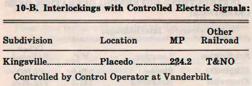
Right: MP's
GCL ETT dated 1-1-1955 shows that by then (and likely earlier) Placedo's
crossing was controlled remotely by operators at an office in
Vanderbilt, sixteen miles north of Placedo. |
 |
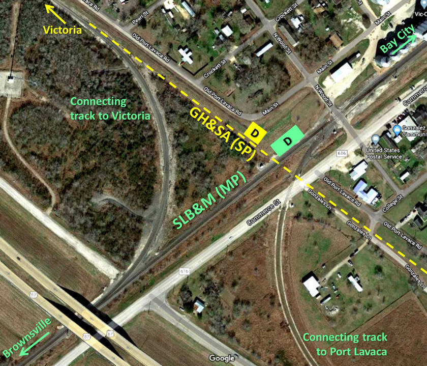 |
Left:
The east quadrant connector (built c.2003) at Placedo enabled traffic
accessing the
new Dow spur to connect with the UP main line to the north. The Victoria
- Port Lavaca "straight through" track was removed, and the new
track crossed over that right-of-way (ROW) and curved back to rejoin
the original track alignment about 2,300 ft. southeast of Commerce St.
This approach avoided relocation of businesses and a Post Office had a
connector been built entirely east of the ROW. The west connector, dating to at least 1929,
is used by KCS trackage rights trains. Both depots were gone by 1957;
their locations are
marked with "D" near the Tower 158 crossing. (Google Earth, January 2017)
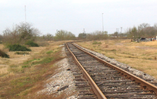
Below: Looking northwest
from south of Placedo along
the original Port Lavaca track alignment, the
tracks abruptly curve west (left) to begin the long sweeping curve back to the
northeast to join the main line to Algoa.
(Google Street View, May, 2023)
 |
Bloomington was not included among the locations
where SLB&M cabin interlockers were
installed in 1929 because both lines at
Bloomington were owned by the SLB&M. The prevailing view among
Texas railroads was that they each had the authority to de-conflict their own
crossings in whatever manner they wished, i.e. RCT approval of the crossing mode
(grade or grade-separated) and equipment (interlocking plant, gate) was only required for crossings that involved two
different railroads. This understanding began to change when RCT insisted that new interlockers for rail
yards be approved (see Tower 116,
Tower 121) even though only a single railroad was typically involved. At
Canyon, where Santa Fe did not seek RCT approval
for an interlocker that involved no other railroad, RCT asserted its authority
by forcing Santa Fe to seek approval, which was quickly granted in late 1927.
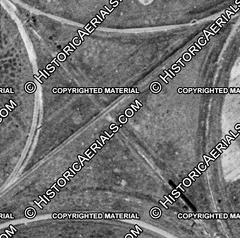 |
Left:
This 1929 aerial image of the Bloomington crossing fails to reveal any
obvious evidence that MP had installed safety controls for the crossing
of the two MP (SLB&M) lines.
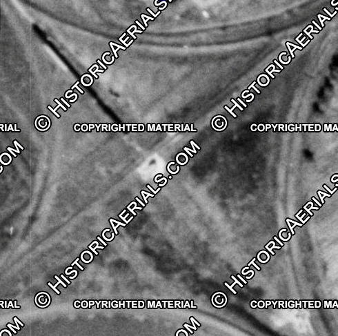
Right: By 1957, there was some kind of cabin or
equipment cabinet (tall enough to cast a shadow) located adjacent to the
Bloomington diamond. If it pertained to safety controls for the grade
crossing, it had not been incorporated into RCT's interlocker numbering
system.
Sometime around 1966, MP decided to install an
automatic interlocker to protect the Bloomington crossing. They sought
and received approval from RCT, and the interlocker became known as
Tower 215, the last numbered interlocker in Texas. Today, there are
connecting tracks at Bloomington in all of the quadrants except the
south. The "straight through" track from Long Mott to Victoria is no
longer intact, hence the diamond and the interlocker are also gone. |
 |
Certainly by the 1930s, RCT had begun to perceive that
its role in approving and managing interlockers wouldn't last much longer. What
made regulatory sense in 1902 no longer applied given the massive changes that
had occurred in the railroad industry. In particular, the Transportation Act of
1920 granted authority to the Interstate Commerce Commission (ICC) to regulate
all aspects of interstate railroading. Because of rate agreements between
railroads that applied nationwide, virtually every railroad in Texas was
considered an interstate
operator. In the early 1920s, the Texas railroads began to apply to the ICC
for approval of railroad company acquisitions, construction projects to build new routes
(e.g. see the story of the Quanah, Acme & Pacific
Railway) and proposals to abandon existing rail lines. RCT had a legal
showdown with the ICC in 1925 over SP's proposed acquisition of the SA&AP, which
RCT vigorously opposed. RCT
lost.
Texas railroads began seeking ICC permission
to install, modify or remove signal, switch and derail components, completely
bypassing RCT. In some cases, railroads supplied RCT with a courtesy notice
about
changes that were being implemented under ICC authority. It appears that as
RCT's role in regulating Texas railroads began to shrink in the 1920s, RCT
fought back by claiming authority that probably exceeded state law. RCT's insistence on
managing all interlockers -- including yard
interlockers and single-railroad junctions, both arguably outside of its
jurisdiction -- may have been a reaction to the reduced workload of its railroad
engineering staff. Had RCT's role not declined, maintaining the engineering
staff resources and expertise to review and manage sophisticated remote control
systems for switching, communications and signaling would have overwhelmed such
a limited-budget state agency. With ICC's expanded authority along with Federal
safety requirements that all interstate railroads had to meet, RCT's crossing
safety management regime was providing very little value to Texas railroads.
Simultaneous with the rise of ICC authority over Texas
railroading, RCT's
authority over the Texas oil and gas industry had begun to dominate its regulatory focus, just as petroleum engineers had come to dominate
its
workforce. As the railroad engineering staff dwindled, the petroleum engineering
staff ballooned. RCT's limited role in managing interlockers ceased in 1966, and their final
approval was issued for Tower 215 at Bloomington. Every few years, there are bills introduced in the Texas Legislature
to rename the Railroad Commission since it no longer manages railroads to
any noticeable extent.
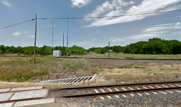
Above Left: Since the Port
Lavaca branch "straight through" track segment was removed when the east
quadrant connector was built, the track in this view is no longer the east
"connector"; it is the Port Lavaca branch
coming off the UP main line at Placedo. Just before crossing the highway, it
passes over the original SP ROW to Port Lavaca (left) and Victoria (right).
(Google Street View, May 2011) Above Right:
This view looks to the northwest along the SP
ROW to Victoria. The start of the Port Lavaca branch is in the foregound. The SLB&M depot was in the grassy area beyond the tracks at
right, with the SP depot further beyond. (Google Street View, May 2011)
In the mid 1990s, KCS acquired 49% of TexMex which has a single main line
between Corpus Christi and Laredo via Robstown. The
TexMex majority owner was the Mexican transportation conglomerate Transportaci�n Maritima Mexicana (TMM) which interchanged with TexMex over the
international rail bridge at Laredo. KCS' nearest service point to Robstown was
at Beaumont, so KCS sought trackage rights on UP
between Beaumont and Robstown. The rights were granted as a requirement of the
UP / SP merger in 1996. KCS' route from Beaumont went west through
Houston to Flatonia
and then turned south through Cuero and Victoria to Placedo. UP's former MP
(SLB&M) tracks covered the remaining 83 miles from Placedo to the TexMex
connection at Robstown. In 2005, KCS acquired the remaining interest in the
TexMex, making it a wholly-owned subsidiary.
KCS also
purchased an abandoned SP ROW between Rosenberg and Victoria, effectively the
endpoints of the hypotenuse of a right triangle with Flatonia. KCS planned to
build a new line on the ROW, but it was delayed for various legal and economic
reasons. In 2009, KCS finally opened new tracks on the former SP ROW,
significantly shortening the time and distance between Rosenberg and Victoria
compared to the UP trackage rights route via Flatonia. KCS now exercises rights on UP's lines between
Robstown and Victoria, and between Rosenberg and
Beaumont, where the KCS
main line goes north to Kansas City. In 2023, KCS
merged with Canadian Pacific, the new company being named CPKC.
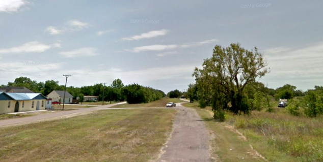
Below Left: Looking south down the
SP ROW from Placedo toward Port Lavaca, the gap in the trees far in the distance
indicates the precise alignment of the tracks. Tracks are not visible in the
foreground because they were removed when the new east quadrant connector was
built. The new track rejoins the tracks to Port Lavaca about
2,000 ft. from the camera. (Google Street View, May 2011)
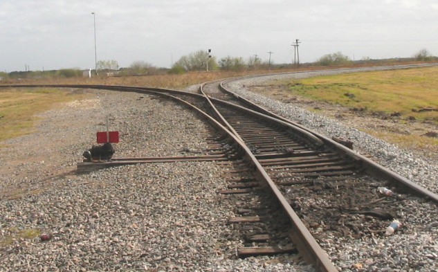
Below Right: With about 850
ft. of the original track at Placedo removed northwest of the diamond, the
tracks coming southeast from
Victoria now curve southwest on the original connector alignment to reach
UP's main line toward Bloomington. This is the trackage rights route for CPKC
trains between Victoria and Robstown. (Jim King photo, c.2006)


Above Left: In 2006 at Placedo, UP
identified the branch connection to the main line as "Port Lavaca Jct." The
signs are no longer present. (Jim King, photo) Above Right: In this
undated photo, an SP train from Victoria curves southwest at Placedo to join the
main line toward Bloomington. Note in the distance that the crossing diamond
was still intact. (photo by Leonard Ruback)
Below Left: Facing southeast at Bloomington, the branch line
from Victoria connects to the UP main line in both directions. (Jim King photo
2006) Below Right: Facing
northwest at Bloomington, the branch from Long Mott curves to the north onto the
UP main line. (Jim King photo 2006)
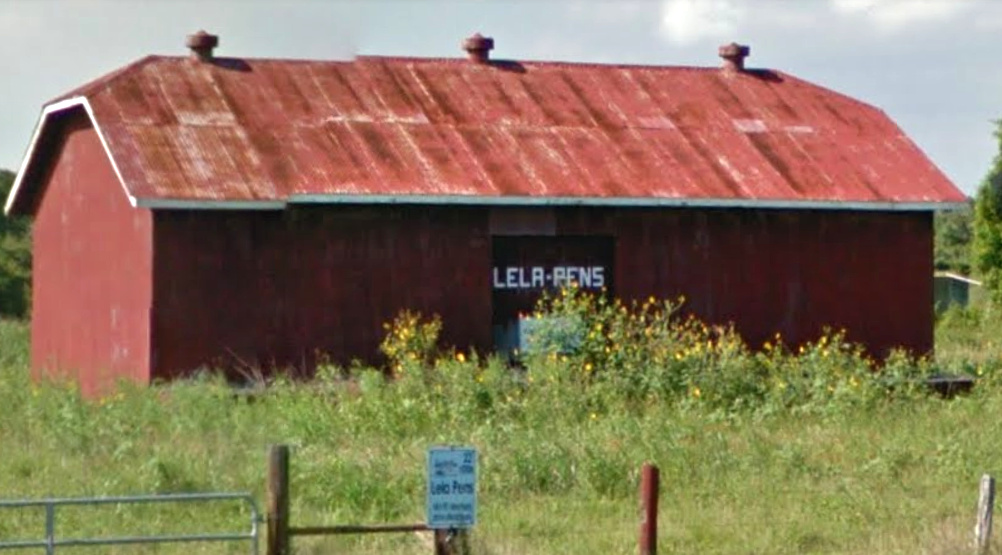 |
Left: Although Lela Pens was
the terminus of the Port O'Connor branch for decades, it doesn't appear on maps
and is not listed in the Domestic Names database maintained by USGS. But Google Street View
shows that it exists as a red barn along Hwy 185 about two miles east of Seadrift. The flyer
posted to the gate identifies Lela Pens as stop #22 on the historical tour of
Seadrift published in a 2016 Calhoun County visitor's guide. The guide explains that the barn was built in 1907 by a local
ranching family and the site became the area loading point for livestock
shipments by rail. The tracks were located
in the foreground between the highway and the barn. (Google Street View, 2016)
Street View shows that as of April, 2023, the building remains
standing, but the flyer atop the gate is no longer present. |

Last Revised: 12/20/2025 JGK - Contact the Texas
Interlocking Towers Website