Texas Railroad History - Tower 202 - Cleveland
A Crossing of the Texas & New Orleans Railroad and the
Gulf, Colorado & Santa Fe Railway
 |
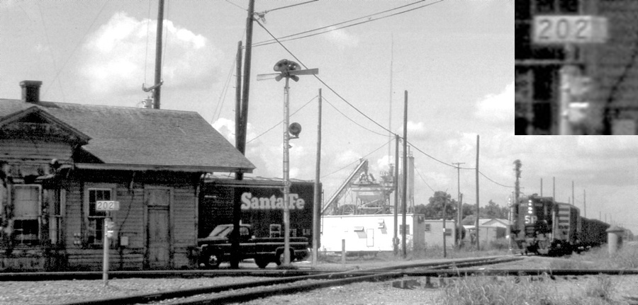
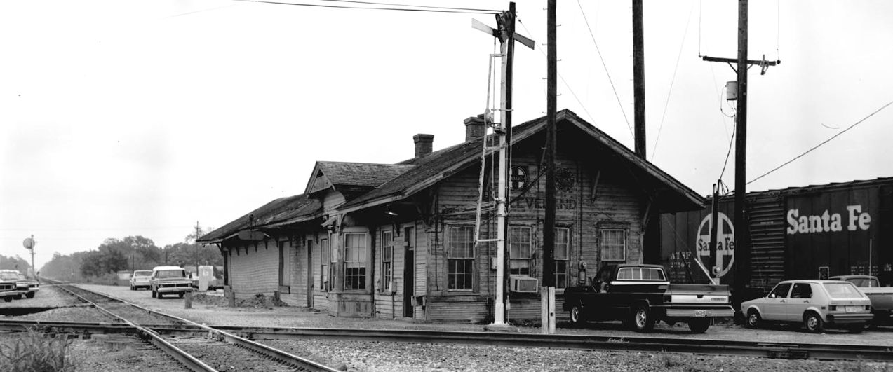
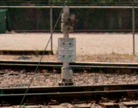
Left Top: The "202"
atop the chrome post across the Santa Fe tracks from the Cleveland depot
(magnified inset at upper right) may not have conveyed useful
information to bystanders, but it directed railroaders to the location
of the override controls for Tower 202, an automatic interlocking plant.
The controls were housed in the boxes visible on the side of the post,
one for each railroad, and were used by train crews to override the
signals for the adjacent grade crossing of two railroads. At the time it
was interlocked (1954), the crossing carried trains of the Gulf,
Colorado & Santa Fe Railway and the Texas & New Orleans Railroad, a
Southern Pacific (SP) subsidiary.
The camera faces south across the diamond with SP's
track nearest the camera to the left proceeding north-northeast to
Lufkin. The Santa Fe track beside the depot
heads northeast (left) but soon turns east to reach Silsbee. SP's
locomotive is approaching the depot on a track that leads back to Houston, 43
miles southwest. The Santa Fe line
at the right edge of the image continues southwest to Conroe.
At some undetermined date, probably after 1939, SP began sharing Santa Fe's depot
for passenger operations. This certainly made it easier for connecting passengers
since SP's depot was a half-mile away.
The Santa Fe boxcar is sitting on a stub track
that was originally a depot lead for Santa Fe trains. It
comes off of a connecting track (still intact) behind the depot that facilitated
freight interchange between the railroads. (photo June, 1980, Joe R. Thompson, courtesy
Railroad and Heritage Museum, Temple; from Southern
Pacific's Eastern Lines 1946 - 1996 by David M. Bernstein)
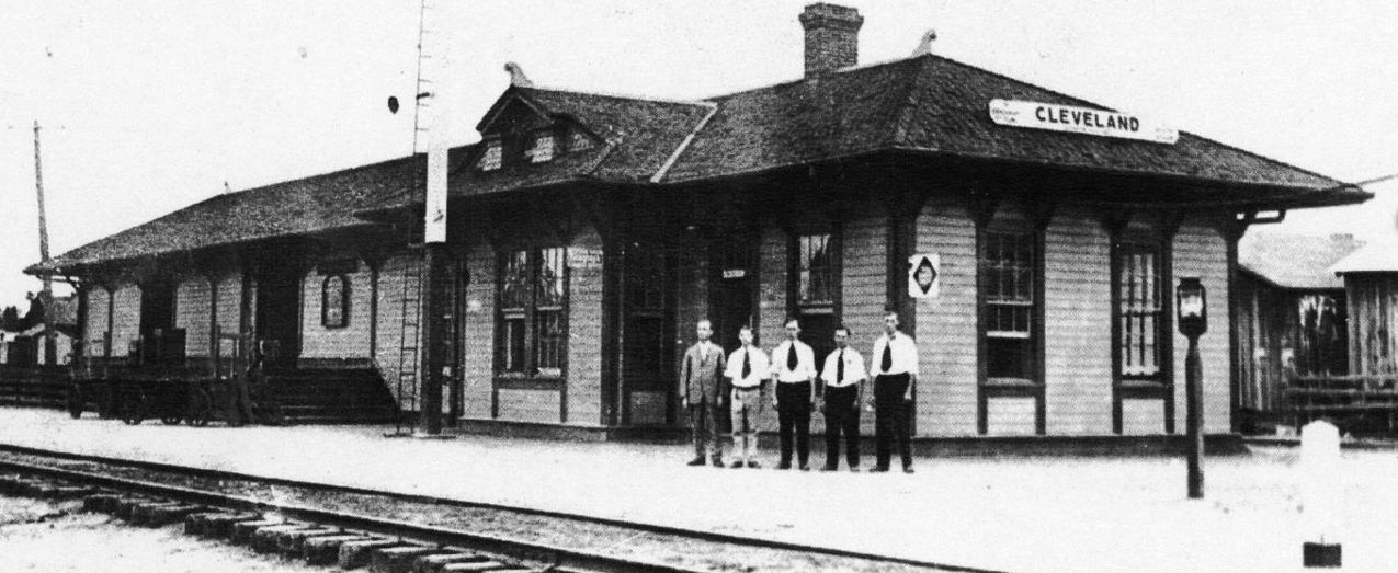
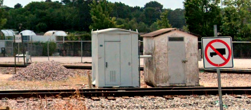
Left Bottom: This photo taken from the opposite quadrant of
the diamond looks generally north-northeast along the SP tracks toward
Lufkin as an SP caboose passes over the diamond. The depot was built by
Santa Fe sometime before 1930 and served as a freight and passenger
station. It later became the joint depot; the faded heralds of both
railroads are visible in the photo. The white cabin near the
Santa Fe tracks housed the automatic interlocking plant. The "202"
control stand is barely visible in the shadow of the railcar between the cabin and the SP tracks.
The sign was square with numbers on all sides so that train crews could recognize it
from any direction. This may be the only interlocker number sign in
Texas to have been mounted atop a control post. More typically they were
mounted on the sides of nearby towers,
depots, cabins,
equipment cabinets or yard offices. (photo Moon Young, November 4, 1982, courtesy Cleveland Historical Society -
Museum.) |
Cleveland began as a railroad town, named by the Houston East & West Texas
(HE&WT) Railway for Charles Lander Cleveland who donated acreage for the
community in 1878. The HE&WT had begun building north out of
Houston in 1877
toward Shreveport,
eventually reaching Nacogdoches in 1882 and the Louisiana state line in 1885.
The HE&WT was built as a narrow gauge railroad which limited
opportunities for exchanging traffic with standard gauge railroads. This
limitation was overcome when the HE&WT converted the entire line from Houston to Shreveport to standard gauge on
a single day, July
29, 1894. Five years later, Southern Pacific (SP) bought the HE&WT, which continued to operate
as a SP subsidiary. In 1927, the HE&WT was leased to the
Texas & New Orleans (T&NO) Railroad, SP's principal operating subsidiary in
Texas and Louisiana. In 1934, the HE&WT was fully merged into the T&NO
as were several other SP subsidiaries.
In 1892, the Texas, Louisiana &
Eastern (TL&E) Railroad built 22 miles east from
Conroe to Cleveland. It crossed the HE&WT and continued six miles farther east
in 1893 to a location the railroad called Meriam (named for a TL&E
Director; it no longer exists, if it ever did -- it may simply have been a
signpost and a wye.) At
Conroe, the TL&E had a connection with the Gulf, Colorado & Santa Fe
(GC&SF) Railway
(a subsidiary of the Atchison, Topeka & Santa Fe Railway -- "AT&SF".) The GC&SF line extended west from Conroe to
a main line connection at Somerville. The TL&E also connected at
Conroe with the north / south International & Great Northern (I&GN) Railroad.
The TL&E entered bankruptcy in 1894 and was sold to
the AT&SF in 1897, which merged it into the GC&SF. Four years later, Santa Fe resumed construction
eastward, reaching Silsbee in 1902. Santa Fe's goal was to serve sawmills in
east Texas for the substantial traffic in wood products they could ship by rail.
By this time, Santa Fe had
acquired the Gulf, Beaumont & Kansas City Railway line at Silsbee which ran
south to Beaumont and north into the forests of east Texas.
By 1906, new construction combined with other acquisitions enabled Santa Fe's
northward tracks from Silsbee to reach Longview.
Beaumont provided Santa Fe with an export outlet via the Neches River and
Sabine
Pass into the Gulf of Mexico. Back to the west at Somerville, the branch to Silsbee came off of the Santa Fe main line between
Galveston and Temple,
which extended north through Fort Worth into
Oklahoma and the Midwest. In 1902, Cleveland's proximity to
sawmills combined with its hot weather and plentiful rainfall led Santa Fe to designate a 2.5 mile section of nearby track as a test
facility for evaluating various methods for wood preservation. Treated wood was
used extensively by railroads for ties, piles, trestles and telegraph poles.
Cleveland's weather created a
stressful environment for wood products, helping to validate the results
from the test track.
The HE&WT and GC&SF rail lines crossed in Cleveland
at an acute angle northeast of downtown. The HE&WT's alignment was
north-northeast / south-southwest. The GC&SF's tracks ran northeast / southwest
through Cleveland but it was generally an east / west rail line from Somerville
to Silsbee. Santa Fe's local track
orientation resulted from the decision to swing north around a swampy area of
the Trinity River as the construction proceeded east to Silsbee.
 |
Left: In the early
1900s, SP's primary railroads in east Texas were the HE&WT,
the T&NO and the Houston & Texas Central (H&TC), which connected
Houston
with Dallas. The last of these SP rail
lines to be completed was a T&NO line in 1902 between Beaumont and
Dallas that crossed the HE&WT north of
Kountze at Nacogdoches.
Among numerous interlocking towers in
Houston, Towers 26,
71 and 76 involved the HE&WT. In addition to Tower 202, the Santa Fe line through Cleveland
had crossings at Conroe,
Dobbin and
Navasota that were eventually interlocked. Outside of
Houston, there were also interlockers on this map at
Brenham, Bryan, College Station, a second interlocker (Tower
9) at Navasota, and Towers 31,
32, 74 and 103 at Beaumont.
The Santa Fe / T&NO
crossing at Kountze was not interlocked. West of Dobbin and south of
Dobbin, the I&GN crossings of the GC&SF and the Trinity & Brazos Valley
(T&BV) Railway, respectively, were
grade-separated. |
 |
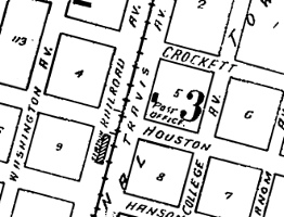
Left: The index map for the 1926 Sanborn Fire Insurance map
set of Cleveland depicts Santa Fe's depot in the acute angle northeast of the
diamond parallel to the Santa Fe tracks. That depot does not appear on aerial
imagery from 1930 which instead shows the depot (photographs at top of page) sitting in the southeast quadrant. The 1939 Sanborn map labels
it solely as a GC&SF depot.
Right: SP had its own depot trackside in downtown Cleveland
as depicted on the 1926 Sanborn index map. It continued to appear on aerial imagery as late as 1959. The year the
railroads began sharing the Santa Fe depot in Cleveland as a joint passenger
station remains to be determined. Being on SP's main line between
Houston and Shreveport, Cleveland enjoyed regular SP passenger service
but it ended in September, 1955. The Santa Fe line was a secondary route
that offered passenger service between Somerville and Beaumont. At
various times, Santa Fe
used mixed trains (freight and passengers) and motorcars. |
 |
Above: joint Santa Fe /
Southern Pacific depot, May, 1979 (Sandra Batey photo)
Below: HE&WT depot in 1917 (Cleveland Historical Society)
The crossing at Cleveland is reported to have been
controlled by STOP signs until it was finally interlocked in 1954. When the 1901
law took effect granting the Railroad Commission of Texas (RCT) the authority to
manage railroad crossing safety, RCT mandated swing gates and STOP signs at all
crossings until they could be scheduled for interlocker installations. By law,
all trains had to stop completely before proceeding across an uncontrolled
crossing, and swing gates did not alleviate this requirement. The railroads
convinced RCT that not every crossing was appropriate for an interlocker, and Cleveland
might have been a good example. Trains approached a town like
Cleveland at low speeds because virtually all of them stopped at the depot, or
perhaps nearby to take on water. The Santa Fe depot was directly adjacent to
the crossing and the SP depot was only a half mile away. A swing gate with a
STOP sign was adequate because its position could be viewed from the depots. At
many locations the default ("normal") gate position was detailed in employee timetables
(ETTs) and employees were usually instructed to ensure the gate was in the
default position after a crossing. The default gate position could change over
time as specified by the current ETT. In some cases, employees were advised to
leave the gate in its last used position. Whether this was true
for Cleveland has not been determined. Eventually, trains were allowed to
approach gated crossings at restricted speed such that a decision by the
engineer whether to continue or STOP could be made within the necessary stopping
distance based on the position of the gate. Thus far, no ETTs have been found
that mention gates or STOP signs at Cleveland. A GC&SF ETT dated July 23, 1939
warns "All trains and engines must stop at following crossings at grade.",
followed by a list that includes the T&NO crossing at Cleveland.
SP
merged and dissolved the T&NO in 1961, as did AT&SF with the GC&SF in 1965. In
1995, Burlington Northern merged with AT&SF to create Burlington Northern Santa Fe (BNSF) which now
owns the former GC&SF tracks through Cleveland. It is a secondary route
connecting Silsbee and other east Texas locations with BNSF main lines at
Dobbin and
Somerville. Union Pacific (UP) acquired and merged SP in 1996 and now owns the former T&NO tracks through Cleveland,
which continue to carry substantial traffic between Houston and Shreveport.
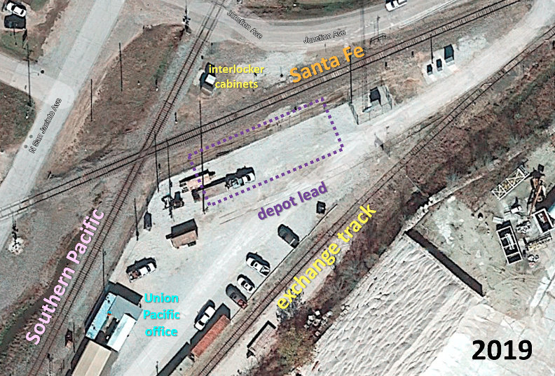 |
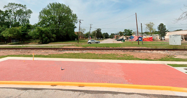
Left:
This Google Earth satellite image from 2019 shows an overhead view of
the area beside the Tower 202 crossing. The joint depot (purple dashes)
is no longer standing. Historic aerial imagery shows it was removed
between 1983 and 1995. UP has established a makeshift office from
temporary buildings adjacent to its ex-SP tracks. The exchange track
remains intact while the depot lead is barely visible. The original
automatic interlocking cabinet (dark roof) sits in its original
location, now flanked by its replacement (white roof.)
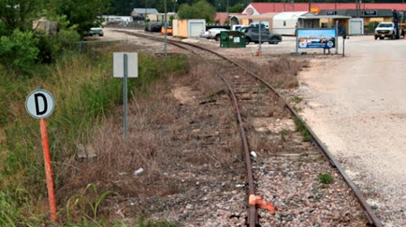
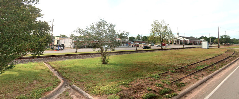
Below: This Google Street View from June, 2022 looks southwest along the
exchange track from near the BNSF (ex-Santa Fe) connection. An orange
derail and a warning sign protect the main line from potential loose
cars on the exchange track. The depot lead appears to have been removed
as no switch is evident.
|
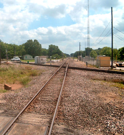

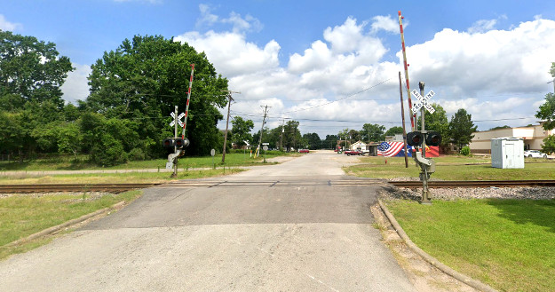
Above:
These Google Street Views from June, 2022 show the Cleveland crossing in three
directions: Left: looking
northeast along the BNSF tracks toward Silsbee;
Center: looking south-southwest along the UP tracks
toward Houston; Right: looking southwest along the BNSF tracks to Conroe.
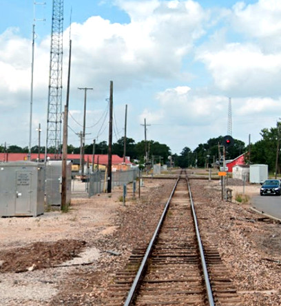
Below Left:
The original interlocking cabinet continues to sit where it did in the 1982
photo at top of page. A newer cabinet sits beside it, presumably associated with
interlocking and signal electronics since there is an electrical conduit pipe
penetrating the adjacent sides of both cabinets. The conduit might serve as a
simple means to access the override signaling from the control post since that wiring was buried long ago. Below Right:
The original override control post has been replaced by a shorter post with
written instructions attached. The "202" sign is no longer present, but the post
appears to be in the same spot. (both images Google Street View, June,
2022)
Above Left: The downtown site
of the HE&WT (later T&NO) passenger station still shows the depot lead track in this Google
Street View from April, 2021. Originally, the track continued past the depot and
rejoined the main line to the left. The white cabin and the (barley visible)
crossing gates are at the Hanson St. grade crossing.
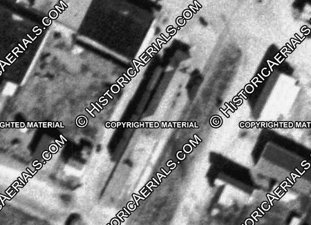
Above Right: This aerial image
((c) historicaerials.com) from 1931 shows the T&NO depot with a
short passenger train parked on the depot lead. The detailed 1939 Sanborn Fire Insurance map of
the depot area shows that the main track and the
depot lead were the only tracks nearby. Below: Google
Street View's images looking north on Hanson St. toward the tracks show
that the grade crossing (left)
was still intact in June, 2022, but had been removed (right)
by March, 2023. The depot lead was also removed.