Texas Railroad History - Tower 70 - Dobbin
A Crossing of the Trinity & Brazos Valley Railroad and the
Gulf, Colorado & Santa Fe Railway
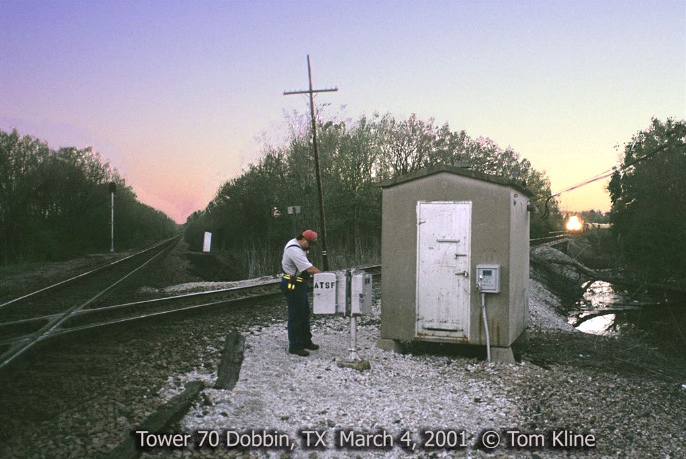
Above Left: Comments by Tom
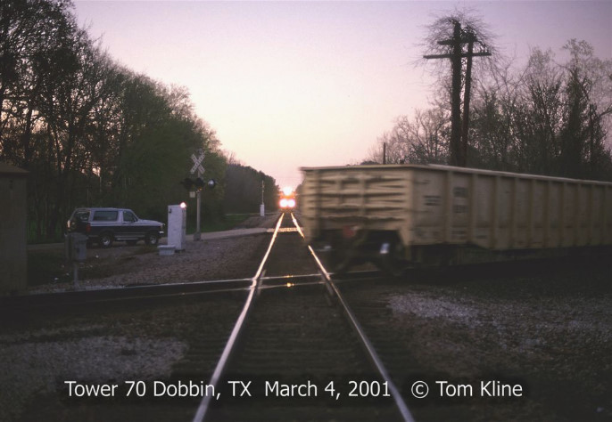
Kline from 2005..."On the evening of March 4, 2001, we see Burlington Northern Santa Fe
(BNSF) conductor Charlie Holson
opening the control box marked ATSF
for the Tower 70 cabin interlocker at Dobbin. Charlie has walked
down from his train (seen
stopped in the distance at the absolute signal) which is traveling east on the
former Atchison, Topeka & Santa Fe (AT&SF) Conroe Subdivision between
Somerville and Silsbee. Charlie is pushing a button in the box which will check
the track circuits for traffic on
the BNSF Houston Subdivision running behind him. If the interlocker finds the Houston
Sub clear, Charlie's engineer will see
a green signal to proceed through the crossing. The Houston Sub is the section of the former
Burlington - Rock Island (B-RI) main line between
Teague and Houston. BNSF trains on the Houston Sub do not need to stop at this interlocker
unless it is occupied. When they do receive a stop indication,
their crews follow the same procedure by pushing buttons in the adjacent box
marked BN."
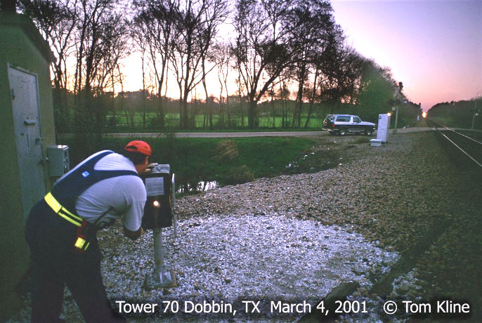
Above Right:
"While the interlocker is going through it's timing procedure, a southbound
BNSF train arrives in the distance just
as Charlie gets a permissive white light on the control panel in the box. Even
though trains on the
Houston Sub normally have the right of way, this one will have to
wait since Charlie has already obtained permission for his train to cross the
diamond." The above photos are facing opposite directions
along the former B-RI tracks, southeast toward Houston (left) and northwest
toward Teague (right). Sometime after Tom took these photos, the Tower 70 interlocker was
converted to a fully automatic plant.
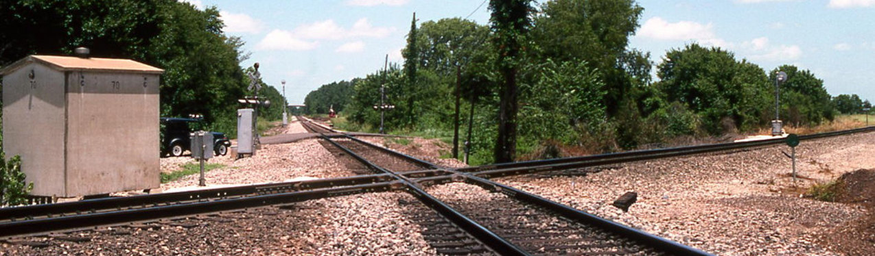
Below: This image looking north across
the diamond was taken by Tom Kline on July 1, 1995, a few weeks before final
approval of the merger that created BNSF. The tracks here meet in an X-pattern
with an
acute angle (visible in the image above left) to the north and south. The wide
angle of Tom's camera renders the appearance of a 90 degree crossing. In this
view, the AT&SF line crosses northeast-to-southwest
(right-to-left) and the former B-RI line goes northwest-to-southeast (top-to-bottom.)
The interlocker cabinet sits due west of the diamond. Note the manual
interlocker control stand adjacent to the cabin and the "70" stenciled on two
sides of the cabin.
The Central & Montgomery (C&M) Railway was chartered in late 1877 by
Montgomery interests to build a 25-mile rail line from Montgomery west to
Navasota. The tracks into Navasota were completed
in 1878, and a connection was made to the Houston & Texas Central
(H&TC) Railway. The H&TC was the major north/south line
in Texas at the time, and its service to Houston
would be handy for citizens of Montgomery County. But if getting to Houston had
been the only consideration, it would have been shorter to build 18 miles east
from Montgomery to reach tracks of the International & Great Northern (I&GN).
The I&GN ran north/south through Montgomery County and provided a shorter route
to Houston compared to the Navasota connection. At the time, however, there was
no community and little population along the I&GN due east of Montgomery,
whereas Navasota was a legitimate town with a population over 1,500 that would
help generate the regular commerce on which the C&M would depend.
In 1882, the C&M was
sold to the Gulf, Colorado and Santa Fe (GC&SF) Railway. The GC&SF main line
ran from Galveston to Ft.
Worth, with construction of a second main line proceeding northwest out of
Temple toward the Texas Panhandle. The GC&SF viewed
the C&M as a target of opportunity to begin establishing a route into east Texas to
capitalize on the vast lumber business conducted there. The GC&SF planned for
the line to penetrate farther east to Beaumont to establish an outlet to the
Gulf for east Texas timber products. To assemble the line to
east Texas, the GC&SF built 29 miles from their main line at Somerville east to
Navasota in 1883 to reach the western extent of the C&M's rails. In 1885,
they laid 18 miles of track from the C&M's terminus at Montgomery eastward to Conroe
where a connection to the I&GN was made. A short distance west of
Montgomery, the C&M tracks passed through an area that would become settled as
the tiny community of Bobbin.
Another railroad eventually arrived at
Bobbin due to the efforts of Benjamin Franklin Yoakum, a native Texan who had
begun his railroad career working on a track gang for the I&GN. By 1903, he
had become Chairman of the Board of
Directors of the St. Louis San Francisco ("Frisco") Railway. He was
also
named Chairman of the Executive Committee of the Chicago, Rock Island & Pacific
("Rock Island") Railroad, another major Midwest railroad that had been operating
into Fort Worth since 1893. As if those jobs weren't enough,
Yoakum was also a member of the Board of Directors of the Colorado & Southern
(C&S) Railroad which had been formed in 1899 by the merger of two former
subsidiaries of Union Pacific. The C&S controlled the Fort Worth & Denver City
(FW&DC) Railway which operated a main line between Fort Worth and the New Mexico
border at Texline, where it connected with C&S rails to Denver.
The
C&S had Denver - Fort Worth service, but it wanted to be able to offer
single-train service from Denver to the Texas Gulf coast. Such service was also
of critical interest to Yoakum; for a decade, Rock Island had been handing off
southbound freight to Southern Pacific (SP) to be carried from Fort Worth
to Houston. More recently, Yoakum had built Frisco rails to the outskirts of
Dallas in 1902 where, again, SP was the primary option for handling southbound
freight to Houston. SP was Yoakum's primary option because the other two
railroads with service from Dallas and Fort Worth to Houston/Galveston -- the
GC&SF and the Missouri , Kansas & Texas ("Katy") -- were major competitors of
both the Frisco and Rock Island in the Central Plains and Midwest. The I&GN had
inaugurated a new Fort Worth - Houston line in 1902 and had begun to carry some
of Rock Island's loads, but it did not serve Dallas.
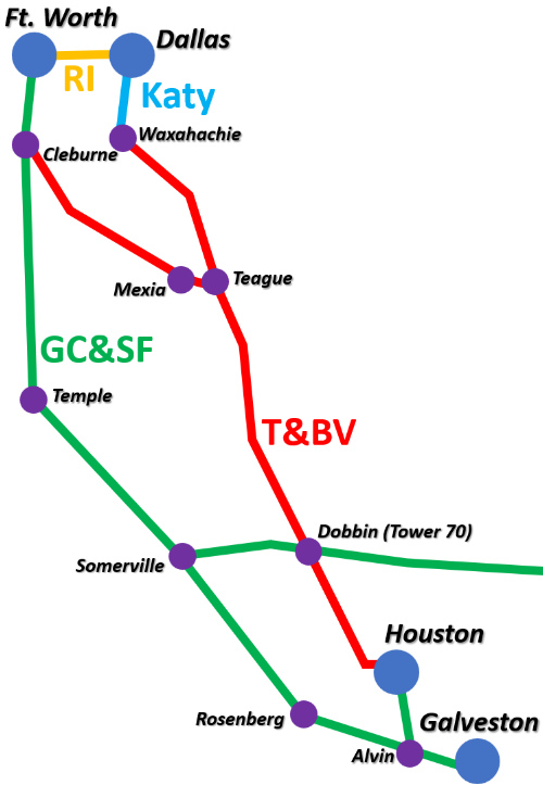
Above: routes from
north Texas to Galveston for the T&BV and GC&SF |
Yoakum's new line
to Houston would depart from Dallas rather than Fort Worth. Although the
Frisco had rights on the St. Louis Southwestern Railway from Carrollton to
Fort Worth, a Rock Island line to Dallas continuing to Houston
became the preferred plan as it would also facilitate Rock Island passenger service
into Dallas, a growing metropolis of 50,000 (almost twice the size of
Fort Worth.) Rock Island had surveyed a direct route from Dallas to
Houston that had few curves and low gradients, making it potentially
much faster than the competing SP route. To begin
executing Yoakum's plan, Rock Island laid tracks from
Fort Worth to Dallas in 1903. SP
perceived a true threat to its north/south main line should Rock
Island build on their surveyed route. They countered by making a very attractive offer to create a joint operating structure
that would not only operate between north Texas and Houston/Galveston,
it would include a shared route between Dallas and Beaumont. Rock Island accepted SP's
proposal; the contract was submitted to the Railroad Commission of
Texas (RCT) in May, 1903, but RCT would not approve it.
Yoakum began executing Plan B. Rock Island's charter included permission to continue the
Fort Worth -
Dallas line south to
Houston and Galveston, but Yoakum was looking for a faster solution.
In 1905, Yoakum had the C&S acquire the Trinity & Brazos
Valley (T&BV) Railroad which had been chartered in 1902 to build a line between Cleburne and
Beaumont. At the time, T&BV
rails were complete from Cleburne to Mexia
(and ran within a mile of Yoakum's birthplace, Tehuacana.)
Yoakum was able to revise the T&BV charter to build east from Mexia to
the community of Brewer (which he renamed Teague, his mother's maiden
name.) From there, he would build north to Dallas and south to Houston.
Yoakum personally contracted with C&S to complete the T&BV construction
in accordance with his plan. He also arranged for C&S to sell half of
the T&BV to Rock Island. Yoakum was able to negotiate rights on the GC&SF between Cleburne and Fort Worth, and between Houston
and Galveston. He also obtained rights on the Katy between
Waxahachie
and Dallas, eliminating the need to find a suitable right-of-way into
Dallas from the south. By 1908, the C&S was advertising single-train service from
Denver to Galveston using the T&BV route from Fort Worth through Cleburne, Teague and
Houston.
 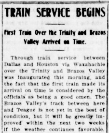 Trains
began running from Cleburne to Teague on March 16, 1906. Building north
and south from there, the tracks arrived
in Houston in late 1906, but service to Houston from Ft. Worth via Teague did not
commence until January 28, 1907. The Houston - Dallas service via
Waxahachie began July
1, 1907. Trains
began running from Cleburne to Teague on March 16, 1906. Building north
and south from there, the tracks arrived
in Houston in late 1906, but service to Houston from Ft. Worth via Teague did not
commence until January 28, 1907. The Houston - Dallas service via
Waxahachie began July
1, 1907.
Left:
Houston Post, January 28, 1907
Right:
Waxahachie Light, July 1, 1907 |
As the T&BV was building south from Teague toward Houston
in the summer of 1906, they crossed Santa Fe's tracks between Conroe
and Navasota a mile northeast of the small community of Bobbin; the crossing
formed an X-pattern with acute north and south angles. In its
correspondence with RCT, T&BV used Bobbin as the location of the crossing,
even though it was not particularly close to the actual community. Santa Fe's
depot was at Bobbin whereas T&BV opened their depot near the crossing,
but they still called it Bobbin. Whether Santa Fe objected is
undetermined, but having two Bobbin depots a mile apart in a rural area
with no ground transportation options could be confusing to
travelers expecting to change trains conveniently. Since Santa Fe already stopped at their
depot, they were not interested in making a second stop at the crossing for passenger and express freight
interchange. A community sprang up near the crossing, and it quickly grew to be larger than Bobbin.
By the end
of 1908, the new community had grown large enough for the postmaster at Bobbin
to decide to relocate his post office to the crossing.
 |
Left and
Right:
(Austin
Statesman, April 18, 1906) The T&BV had laid tracks a few
miles north and south of the Bobbin crossing months before the main
track arrived from Teague. This apparently convinced RCT to proceed with
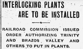
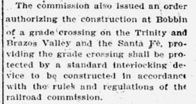
an order to protect the crossing well before service started. RCT's order
required that the T&BV / Santa Fe grade crossing at Bobbin be
"protected by a standard interlocking device." The other
interlocker ordered by RCT at the same time was for
Tower 69 at Celeste; the Bobbin interlocker
became Tower 70. It commenced operations on April 25, 1907 as a
12-function mechanical plant. This was a standard configuration for
simple crossings consisting of a home signal, a distant signal and a
derail in each of the four directions. |
 |
At some point in early 1909, the name Dobbin
became associated with the crossing and the new post office located there. The similarity between Bobbin and
Dobbin suggests that this was not an accident. Yet,
by coincidence, there happened to be a Santa Fe
executive, Garrett Dobbin, who functioned as the railroad's "colonization agent"
during this period. His activities to promote industrial and residential
immigration to Santa Fe communities in Texas were frequently tracked in Galveston and Houston
newspapers. One newspaper made the assertion that the Dobbin community was indeed
named for Garrett
Dobbin, but it does not
say how, by whom or when the decision was made. Making the claim even less
authoritative, the news item was only one sentence long and
it was in the Palestine newspaper, a town a hundred
miles away having no association with either of the Bobbin railroads.
No other contemporary sources have been found to substantiate this claim. (These
sorts of odd news tidbits typically came from wire services, so they
tended to appear in multiple small town newspapers trying to fill space, but
apparently, not this story.) Stranger still, despite newspapers published in
nearby Conroe, Montgomery and Navasota, no local news stories
at all have been found discussing the new name of Dobbin. And
since the name change affected T&BV's Bobbin station and timetable,
a story might be expected from the newspaper at Teague (where the T&BV had a
yard, major offices and shops) but research has turned up nothing.
Perhaps Santa Fe having
an executive named Dobbin tended to point to them as the
instigators of the name change. They certainly had an incentive to create a different name for the
crossing to eliminate confusion with their Bobbin station. Yet, Santa
Fe's Form 598 Official List of Stations
published in early 1910 (hat tip, Ken Stavinoha) does not list
Bobbin at all, but does list Dobbin as Station 8649, telegraph
call sign 'BN', with an agent assigned. Five years earlier, the 1905 list
included Bobbin,
although without a telegraph call sign. If Santa Fe had promoted the idea of
using the Dobbin name to eliminate confusion, then the name of their
Bobbin depot should have remained unchanged in
the 1910 list. Instead, it appears they felt compelled to rename their station
to Dobbin since the
Bobbin name was disappearing, at least officially as recognized by the Post
Office. Obviously, some person or group chose the Dobbin
name
for the crossing and apparently prevailed upon the postmaster to institute the name change for his relocated post office. There are
later written histories that assert that
Bobbin was simply renamed Dobbin, but that's a
bit of oversimplification. Certainly the post office was renamed when it moved
to what was effectively a new community, but the locals at Bobbin still
identified as such. There are contemporary newspaper
articles that reference both Bobbin and Dobbin, and as late as
March, 1911, the Conroe Courier was still
running an occasional local news column titled Bobbin. Regardless of
how it happened, having two depots a mile apart with the same name remained both confusing
and inconvenient for travelers.
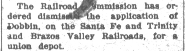
Dobbin residents filed a complaint with RCT requesting an order to require
the two railroads to build a union passenger station, but RCT dismissed their
case in December, 1910.
In 1911, residents at "old Bobbin"
sought a post
office to replace the one they had lost to Dobbin in 1909, and they chose to
apply under the name Bobville. It was eventually granted, at least by
1915 though the
date is undetermined. On April 30, 1915, Post Office officials sent a form
addressed to "Postmaster at Bobville, Montgomery County, Texas"
requesting updated topographical data for the location of his post office. Among
other details, his response stated that his post office was 150 ft. south of the
GC&SF tracks near the Dobbin station. Apparently, Santa Fe had
continued using Dobbin as the name of their former Bobbin
depot and had not yet adopted Bobville. This is confirmed by Santa Fe's
Form 598 station list published in early 1915.
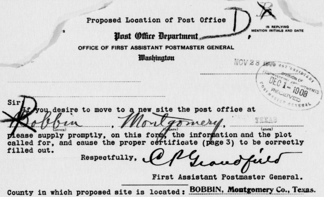
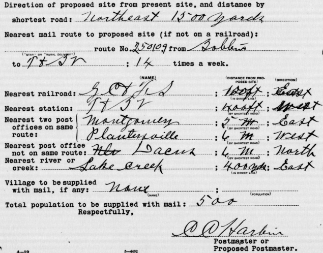
Above: On November 23, 1908, the Post
Office Department mailed a form to the postmaster at Bobbin requesting specific
details on the new location being proposed for the Bobbin post office. The
response was received back in Washington D. C. at the Division of Postmasters' Appointments on December 1st. (!) It states the
new site is "Northeast 1500 yards" (just under a mile) from the old one.
Somewhat illegible are the distance and direction of the nearest railroad
("GC&SF") and station ("T&BV") from the new site. Note that at some later date,
the 'B' in Bobbin was crossed out, replaced by a 'D'. This was a record-keeping markup
made by clerks at the Post Office Department so that the paperwork could be
re-filed under 'D' instead of 'B' (as evidenced by the alphabetic notations in
the upper right corner; clerks always wrote the first initial of the town in the
upper right corner so they could file stacks of forms more quickly.) Clerks went
back and applied the exact same 'D for B' markups on the
original Bobbin paperwork from 1883 so that all of the Bobbin/Dobbin paperwork
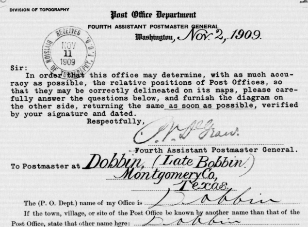
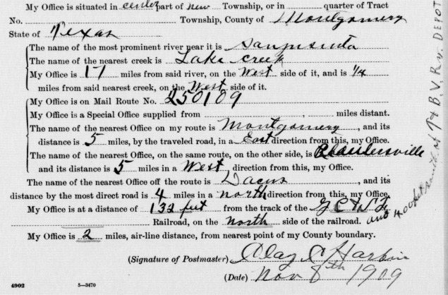
would be filed together. Below: On November 2, 1909, the Division of Topography
of the Post Office Department mailed the postmaster at
"Dobbin (Late Bobbin)" requesting a geographic location update for his post
office. The postmaster's response was signed on November 8th and received
back in Washington D. C. on November 11th (!)
Among the information provided, the Dobbin post office was in the "center part
of new township" and was "132 feet from the
track of the GC&SF Railroad, on the north side of the railroad", with the
additional comment that it was "400 feet south of the T&BV Ry. depot."
This places the T&BV Dobbin depot approximately 500 feet north of the crossing. (National
Archives)
Regardless of the name applied to Santa Fe's former
Bobbin depot, it remained a mile away from the T&BV depot
at Dobbin. The traveling public had undoubtedly experienced
inconvenience attempting to change trains at Dobbin. T&BV decided
to file a complaint with RCT requesting that
Santa Fe be ordered to stop at the crossing to exchange passengers and express
freight. RCT ruled on the complaint with an order issued
May 19, 1916 that required Santa Fe to build a depot at the crossing and
make regular stops. However, the order did allow Santa Fe to "...treat said
station as a flag stop..." Santa Fe completed their depot at the Dobbin
crossing on June 10, 1916, but it might have been nothing more than a boarding
platform with a boxcar shelter.
Palestine Daily Herald, April 6,
1909
Conroe Courier, March 26, 1920 |
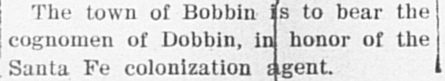
Left, Top: The only newspaper item found thus far
that associates the naming of the town of Dobbin with Santa Fe executive
Garrett Dobbin is from the
Palestine Daily Herald of April 6,
1909.
Right, Top and Middle:
RCT's intent to conduct an August, 1910 hearing on a complaint by the
residents of Dobbin requesting the railroads be ordered to build a union
passenger depot at their crossing was
published in the Austin Statesman
on May 14, 1910. In December, RCT dismissed the complaint.
Right, Bottom: This May, 1907
travelogue begins with a trip from Teague to "Bobbin on the Santa Fe"
which involved getting in late to Bobbin on the T&BV. As this was barely
three months after the T&BV had inaugurated service south of Teague, the
Dobbin name had not yet been adopted. The author exhibits some surprise
at being told to walk "one mile from the T&BV depot to the Santa Fe in
the dark as there was no conveyance..." They managed to find a place to
stay and they departed the following morning from the
Santa Fe depot.
Left, Bottom:
This 1920 article looks back at the railroads' fight over Dobbin and
Bobville (apparently, Bobbin had already slipped from the collective
memory!)
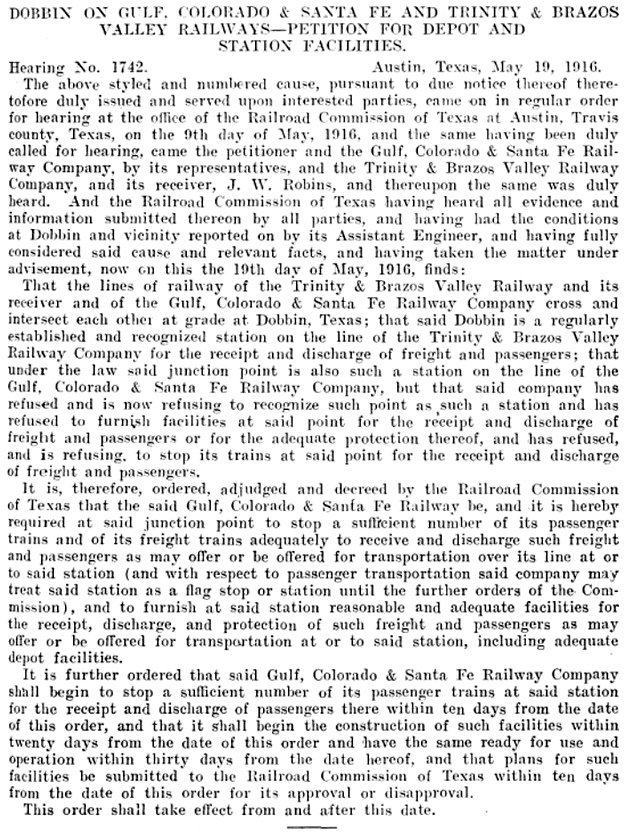
Below: On May 19, 1916, RCT issued a detailed
order in response to a complaint from the T&BV requesting that Santa Fe
be required to stop for passenger and express freight interchange at the
Dobbin crossing. RCT found that while Dobbin was a recognized station on
the T&BV, the "junction point" at Dobbin was legally "also such a
station on the line of the Gulf, Colorado & Santa Fe Railway Company..."
RCT ordered
that within ten days, Santa Fe had to
begin stopping at Dobbin and they had to submit plans for "adequate
depot facilities" for RCT approval. Within twenty days, Santa Fe was
required to commence construction of the depot and complete
construction within thirty days.
Above:
Conroe Courier, June 1 (left) and
June 15 (right), 1916
|
Austin Statesman, May 14, 1910
Grapevine Sun, December 3, 1910
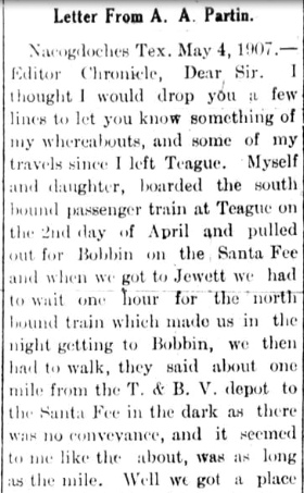
Teague Chronicle, May 10, 1907 |
In accordance with RCT's order, Santa Fe began
accepting and discharging passengers at their new
Dobbin depot, but
only as a flag stop (at least for a few years.) This also meant that the Dobbin station located at Bobville needed a new name. Santa Fe's
Form 598 issued in
early 1917 shows Bobville as the station with the same number and call
sign previously assigned to Dobbin. Dobbin is listed below it
with no information. Santa Fe was providing the bare minimum to comply with
RCT's order: a flag stop depot with nothing else. While passengers could flag
Santa Fe trains at Dobbin, there was no agent, so express freight
routing through
Dobbin for interchange was probably handled between the two railroads
using local transportation by road between their Bobville and
Dobbin depots.
In its annual interlocker reports, RCT continued to list the location of Tower
70 as Bobbin until it began using Dobbin at the end of 1923.
There are no doubt many sordid
details of the Bobbin / Dobbin saga that remain to be
uncovered, but the
Bobbin name did not completely disappear. The Bobbin Independent School District survived
as a legal entity under state law until it was incorporated into the Montgomery
ISD in 1961.
 |
Left:
Dobbin appears in this October 20, 1913 Santa Fe Public Timetable as a
flag stop 49 miles from Somerville, the only stop at all between
Plantersville and Montgomery. This was actually the Bobbin/Bobville
station.
Right: This February 7, 1926 Santa Fe Public Timetable
shows that Bobville had replaced Dobbin as the name of a flag stop
49 miles from Somerville. An additional (non flag) stop at the Dobbin
depot was added a mile farther east. The Form
598 published in early 1923 shows that by then, Santa Fe
had moved its agent and telegrapher to Dobbin. Bobville remained open as
a flag stop with no agent. |
 |
Tower 70 opened at Dobbin on April 25, 1907 to control
the T&BV/GC&SF crossing, but what kind of tower was it? There is evidence that
it was a manned structure, presumably two-stories (one-story manned cabins were
rare but they did exist, in particular Tower 71,
the next tower authorized by RCT, of which,
unfortunately, no photo has been found; MKT Junction
is another example.) The last comprehensive table of active interlockers
published by RCT on December 31, 1930 listed Tower 70 as type "Mechanical"
rather than "M-Cabin", the designation typically used for unmanned cabin
interlockers. In a table dated October 31, 1916, RCT reduced the function count
for Tower 70 from twelve to eleven. What this affected remains undetermined, but
it might not be coincidental that this was the next published report after Santa
Fe established the flag stop at their new Dobbin depot four months earlier.
The 1916 table also happened to be the first one RCT published in which the
railroad responsible for operating the interlocker was identified; for Tower 70,
it was the GC&SF. At first glance, this is surprising. Since the crossing was
created after 1901, RCT rules required the second railroad - here, the T&BV - to
pay the entire capital outlay for the interlocker and associated structures and
signals. Generally, the railroad that built the tower and installed the
interlocker would also take the lead on operating and maintaining it. The recurring "O&M" expenses
(e.g. labor and materials) were
shared between the railroads, usually on a "weighted function" basis
(when an interlocker had 12 functions, it was almost inevitably a 50/50 split.)
Financially, the T&BV did not fare well, but it did
manage to
remain operational during a lengthy receivership that began in 1914. If the T&BV
had been assigned as the original O&M railroad for Tower 70, the
receivership could explain why the GC&SF was listed as such in 1916. A bankruptcy announcement could trigger staffing problems with
employees concerned about paychecks, benefits and job protections. Santa Fe
might have wanted to take O&M responsibility to avoid any potential impact on operations at Tower 70. The T&BV bankruptcy ended in 1930
when a new entity, the Burlington - Rock
Island (B-RI) Railroad, was established to succeed the T&BV. The B-RI was a paper railroad; it used the rolling stock and motive
power of its joint owners, Rock Island and the Burlington system (which had
bought the C&S in 1908.) The Houston - Waxahachie main line with rights into
Dallas was a valuable asset, as was inheriting T&BV's 25% ownership share of the Houston
Belt & Terminal (HB&T) Railway. The Cleburne - Teague segment, however, lacked value as
a bridge route and had little local traffic, so the B-RI commenced abandonment
proceedings. The 30 miles between Cleburne and Hillsboro was the first to go, in
1932. The final fourteen miles
between Mexia and Teague staved off abandonment until 1976.
 Left: As the last car of the eastbound clears the diamond we see the southbound on
the former B-RI is sitting stopped at
the absolute signal. In a few moments, they will get a clear signal to proceed
through the plant and on into Houston.
Left: As the last car of the eastbound clears the diamond we see the southbound on
the former B-RI is sitting stopped at
the absolute signal. In a few moments, they will get a clear signal to proceed
through the plant and on into Houston.
Trans-Communicator, a publication of the
Transportation - Communication Employees Union, reported briefly in its 1929
edition that "Distant signals, Santa Fe BN Dobbin, have been electrified
making it safer for trains and taking quite a strain off the towermen at that
point." BN was the longstanding telegraph call sign for Santa Fe's
Dobbin depot, so by then, the telegraph had been moved to the tower. A B-RI timetable from 1946 showed the GC&SF crossing as
Interlocked with Continuous office hours, 24/7. These items are
both consistent with the assumption that Tower 70 had always been a manned tower.
By 1988, an AT&SF timetable shows Dobbin as an automatic interlocker. It had
been converted to a
cabin interlocker by 2001 when Tom Kline photographed it.
In 1964, B-RI went into
foreclosure so its parent railroads, Burlington Northern (BN) and Rock Island
could each buy an undivided half-interest in its assets with
unrestricted rights to operate over the main line (with
Katy trackage rights into Dallas.) When Rock Island went bankrupt in 1980, BN
took over full operation of the line. When BN merged with the AT&SF in 1995 to
form BNSF, the Dobbin crossing became strictly a BNSF operation.
No
photos of Tower 70 have surfaced thus far, nor have photos been found of either of
the Dobbin depots or the Bobville depot (although there is
one short video!) Tower 70 and the depots nearby remain a substantial
mystery.
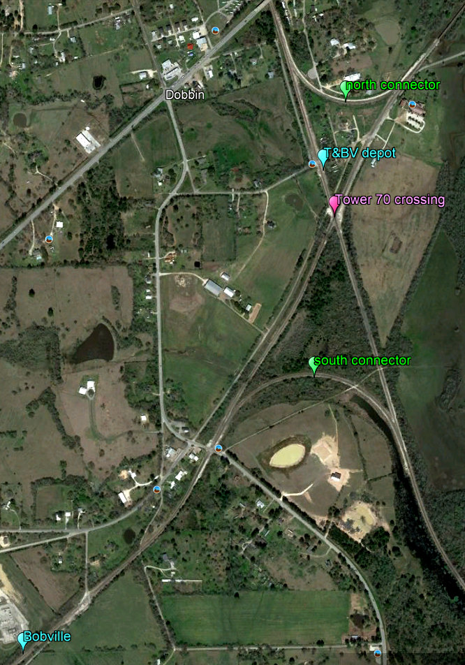 Right:
This Google Earth image has been annotated to show the relative locations of
Bobville and Tower 70 at Dobbin. The T&BV depot location is shown
approximately 500 ft. north
of the crossing, consistent with Post Office records. There are hints from
detailed imagery that the depot was on the east side of the tracks, but the true
location is undetermined, as is the position of the tower with respect to the
crossing diamond.
Right:
This Google Earth image has been annotated to show the relative locations of
Bobville and Tower 70 at Dobbin. The T&BV depot location is shown
approximately 500 ft. north
of the crossing, consistent with Post Office records. There are hints from
detailed imagery that the depot was on the east side of the tracks, but the true
location is undetermined, as is the position of the tower with respect to the
crossing diamond.
Bobville is shown a mile distant by rail from Tower 70,
the best estimate for its location using the available information. This puts it
adjacent to the current Bobville Rd. roughly 300 yards southwest of the Bobville
Rd. grade crossing. Historic imagery shows that there was a siding on the
southwest side of this crossing, and there might have been a small yard during
the early days of Bobbin/Bobville.
Imagery from 1957 shows a connecting
track east of the diamond which probably served to expedite Santa Fe
trains between east
Texas and a connection with the HB&T at
Belt Junction in Houston. Santa Fe and the
T&BV/B-RI were both 25% owners of the HB&T. Santa Fe's route to Houston
from east Texas otherwise required continuing west to Somerville,
turning southeast to Alvin, and then going north to New
South Yard via Tower 81, a substantially longer
route. The connector survived at least to 1983, but was gone by 2004. By then, BNSF
had built a south connector to support BNSF movements between the main line at
Somerville and Belt Junction. Sometime around 2018, a north
connector was built, providing a route for trains operating between Dallas
and Beaumont.
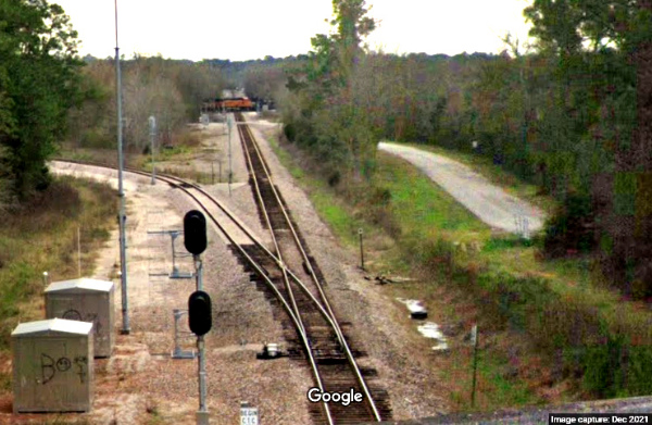
Below:
This Google Street View from 2021 looks south from the TX 105 overpass above the
former T&BV (the overpass is barely visible at the top edge of the map at
right.) A BNSF train occupies the Tower 70 diamond in the distance. The north
connector switch appears in the immediate foreground. Tower 70 would likely have
been visible from this vantage point, along with, presumably, both of the Dobbin
depots.