Texas Railroad History - Tower 56 - McGregor
A Crossing of the Gulf, Colorado & Santa Fe Railway and the
St. Louis Southwestern Railway
 |
Left:
Documentation produced by the Railroad Commission of Texas (RCT) shows
that the Tower 56 interlocking plant became operational on October 22,
1904 serving the Gulf, Colorado & Santa Fe (GC&SF) Railway and the St.
Louis Southwestern (SSW, "Cotton Belt") Railway. The tower was
integrated into the Union Depot built at the same time.
Common for manned towers in Texas, its number is visibly presented as a white
placard on the tower siding. The number and character of passenger stations
that preceded Union Depot during the prior two decades of rail service
is undetermined.
This photo appears on the dusk jacket of the book
Santa Fe Depots: Gulf, Colorado & Santa Fe
Railway by Robert E. Pounds and William W. Childers ((c)
2012, The Santa Fe Railway Historical & Modeling Society, Inc.)
The book describes the photo...
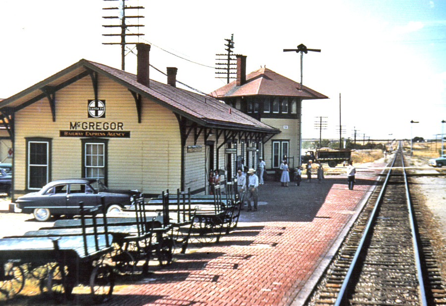
"Photographer K. B. King was
aboard the southbound Texas Chief, Train 15, as it pulled away from
McGregor, Texas on July 1, 1951. Built in 1904, this joint depot with
the Cotton Belt was constructed with an interlocking tower which
controlled the crossing in the background. ... Although missing its tower, the McGregor depot stands today as the
Amtrak station for Waco and the surrounding area..." |
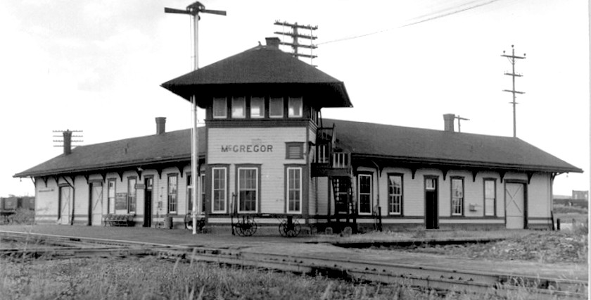 |
Left: The
Union Depot with Tower 56 at McGregor looks symmetrical, but it's not.
Count the eave braces; the Cotton Belt side (right) was shorter than the
Santa Fe side. The depot was in the southwest quadrant of the crossing
(undated photo from DeGolyer Library, Southern Methodist University, hat tip, Myron
Malone.)
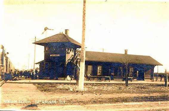
Below: McGregor Union Depot and Tower 56 in 1907
 |
The Gulf, Colorado & Santa Fe (GC&SF) Railway
was founded because Galveston's leaders
wanted to have a second railroad off the Island, preferably one that did not
pass through Houston (for reasons best explained
elsewhere.) To effect its plan, the GC&SF built its own bridge over Galveston Bay to
Virginia Point and proceeded northwest, ostensibly heading for Colorado but
on a path that remained well south of Houston. Tracks reached Brenham
in April, 1880 and Caldwell in early July. On January 14,
1881, tracks entered the railroad's Temple Junction construction camp
(named for GC&SF Chief Engineer Bernard Temple) eight miles east of Belton. It
was considered a "junction" because the GC&SF had chosen the camp to be the departure point for construction of its Northern
Branch, a branch line cited in its Texas railroad charter. As the population in
the vicinity of the camp grew, the Post Office decided that the name would
simply be
Temple.
GC&SF service out of
Galveston was extended to Belton on March 18, 1881, and the "main line" beyond
Belton continued northwest toward Colorado with tracks laid to Lampasas in 1882.
As track-laying entered this vast area where there was plenty of livestock but little population, progress slowed. A branch line to San Angelo
opened in 1888, but otherwise, the end of the "main line" was stuck at Coleman
for more than twenty years. GC&SF management attention focused elsewhere; the real main line would be the Northern Branch.
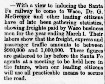 |
Left:
Norton's Union Intelligencer (Dallas)
in its March 20, 1880 edition carried this note about the efforts of Waco's
citizens, led by Dr. Gregor C. McGregor, to convince the GC&SF to build
the Northern Branch through Waco. At this date, the GC&SF had not even
reached Brenham, but its charter requirement for a Northern Branch was
well known. Waco was doing its best to get an early advantage in seeking
the GC&SF tracks. Much to the chagrin of Waco
residents, the Northern Branch passed twenty miles to the west.
Consistent with geography and reputation,
Fort Worth rather than
Dallas was viewed as the future rail gateway to the West,
matching the GC&SF's West-focused philosophy (e.g. Colorado,
Santa Fe in its name.) To build from Temple to Fort Worth, the GC&SF
avoided the soon-to-be hotly contested Waco
market by opting to route via
Cleburne. Waco was already served
by the Houston & Texas Central Railway whereas Cleburne had no
rail service at all. Its population had tripled in the 1870s and efforts
to build a Cleburne - Dallas rail line were already underway.
When rail
baron Jay Gould was elected President of the Missouri, Kansas &
Texas ("Katy") Railway in late 1879, the
industry quickly surmised Gould's intention to build south from the Katy's Red River
bridge (near Denison) to Laredo via Fort Worth and Waco. The GC&SF was a small railroad with limited
capital; it did not want to battle Gould in the Waco - Fort Worth
market. From Temple, a line through Cleburne was the better choice. It
was shorter, and with no direct competition, the GC&SF would have its
pick of right-of-way. |

|
Left: Prior to its tracks reaching Temple
Junction, the GC&SF commenced construction on the Northern Branch.
Existing rail service made Fort Worth a good logistics base for construction equipment and materials. The effort began
with contracts for grading from Fort Worth south to Cleburne awarded on
November 19, 1880. (La Grange Journal, November 24, 1880)
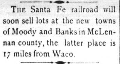
Right:
The GC&SF did not wait long to begin northward construction from
Temple.
The Brenham Daily Banner
of May 18, 1881 reported on plans to sell lots at the new towns
of Moody and Banks. Moody still exists 14 miles north of Temple, but Banks
dissolved when the town of McGregor was founded. GC&SF service to Fort Worth
began in January, 1882. |
 |
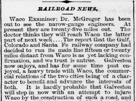 |
Left: The
Galveston Daily News of September 11, 1880 quoting the
Waco Examiner reported on Dr.
McGregor's efforts to guide another line, "the narrow-gauge" railroad, into Waco. The
Examiner
also speculated dismissively about a report that the GC&SF would bypass Waco.
In 1880, the Texas & St. Louis
(T&SL) Railway was laying narrow gauge tracks from
Tyler to Waco with
plans to continue into the ranch lands farther west. The company had
been founded as the Tyler Tap Railroad in 1871 to
bring rail service to Tyler by "tapping" the Texas & Pacific
(T&P) Railway
at Big Sandy. In 1879, the name was changed
to T&SL as a 107-mile segment was built from Big Sandy to
Texarkana, continuing into Arkansas and
Missouri toward St. Louis. In January, 1881, the T&SL claimed the
marketing name Cotton Belt Route, but it was still
called "the Narrow Gauge" by many newspapers though there were other
narrow gauge railroads in Texas (it was converted to standard gauge
c.1887.) Though financial reorganizations ensued, ultimately becoming
the St. Louis Southwestern (SSW or SLSW) Railway, it always remained
the
Cotton Belt. Dr. McGregor, champion of Waco rail service,
monitored its progress and undoubtedly helped in
arranging right-of-way, depot grounds, etc. By the spring of 1881, the Cotton Belt was
in Waco skirmishing with Gould's construction forces over rights-of-way. Gould
had leased the Katy to his Missouri Pacific (MP) railroad and was
marching southward through Texas under the MP banner. MP didn't have a Texas railroad
charter, so Gould assigned track ownership to the Katy (which, as it turns out,
also lacked a Texas railroad charter! But
that's another story...) Long before the Cotton
Belt bridged the Brazos River at Waco in April, 1882, its surveyors had
plotted the route westward to Gatesville, a town that had promised a
$30,000 bonus for rail service. The route crossed the GC&SF near Banks
where the new town of McGregor Springs was founded in honor of Dr.
McGregor. |
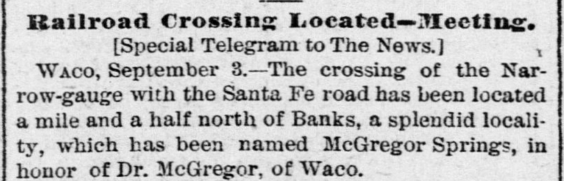
Above: The
Galveston Daily News of September
4, 1881 reported that the "the Narrow Gauge" crossing point of
the GC&SF had been determined. It would become known as
McGregor Springs, in honor of Dr. McGregor.
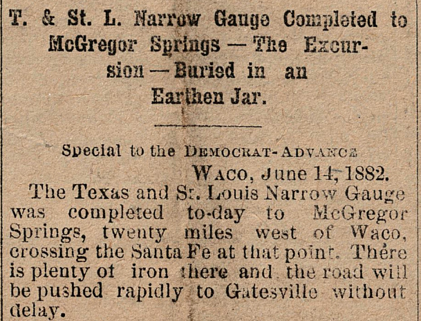
Right: In June, 1882, the T&SL tracks
crossed the GC&SF at
McGregor Springs. Construction was "pushed rapidly" to Gatesville, the
end of the line, arriving in October. (Fort Worth Daily
Democrat, June 15, 1882)
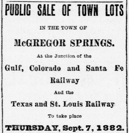
Far Right: The Galveston
Daily News of August 20, 1882 announced the public sale of
town lots at McGregor Springs. |
 |
 |
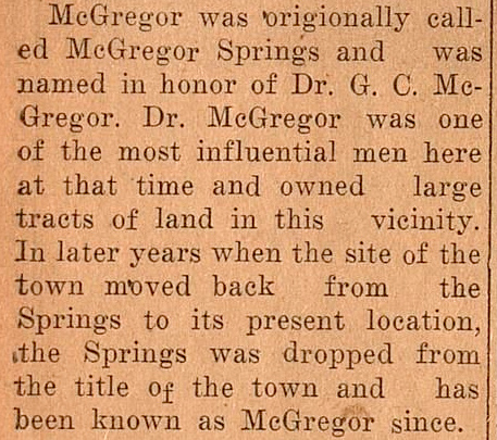
Right:
This excerpt from a lengthy article published in the
McGregor Mirror of July 19, 1940
mentions the town moving "back from the Springs to its present location"
as the reason "Springs" was dropped from the town name. The word 'back'
is a geographic reference, not a time reference; the word 'away' would
have been a better choice. The springs were along Harris Creek a quarter
mile north of the railroad crossing, hence easily accessible land was
available in greater quantity south of the crossing, farther from
the creek and springs, and the town naturally grew in that direction. But the story implies that this growth occurred over many years
to cause the name transition to
"McGregor". Newspapers tell a different story. If it was ever
used, "Springs" was dropped quickly by the railroads in public timetables
and advertisements. Only two months after the sale of town lots, ads in the Galveston
Daily News of November 18, 1882 show the GC&SF (below left)
and the Cotton Belt (below right)
had already begun identifying the town as "McGregor."
As early as mid October, 1882, only six weeks after the sale of town
lots, property deed registrations for McLennan County were using
"McGregor" as the location. The Post Office at Banks was relocated that
same month, but whether it ever used the name "McGregor Springs" is
undetermined. |
 |
In the summer of 1882 as the Cotton Belt was building
through McGregor to Gatesville, the focus of GC&SF management was elsewhere.
They were seriously considering the Chicago, Texas & Mexican
Central (CT&MC) for acquisition. The CT&MC was the railroad that had
finally completed a line between Cleburne and Dallas. It was having financial
difficulties, and the GC&SF
wanted to serve Dallas, which was more populous than Fort Worth. Construction of
the Dallas -
Cleburne line had been overpromised and poorly delivered, but its inevitable
completion as a branch to Dallas
formed part of the rationale for building the Northern Branch
through Cleburne. It was time to act, so the GC&SF made the purchase on August
1, 1882. Gaining Dallas as a service market was a strategic move that
unfortunately did nothing to solve the GC&SF's biggest problem -- it was entirely dependent on local traffic. Unless
the GC&SF could find a partner to stimulate traffic from out-of-state markets,
it was destined to become subservient to the bigger railroads in Texas: Southern
Pacific (SP) and the
Gould companies (the Katy, the T&P, and the International & Great Northern,
Texas' largest railroad.)
The obvious suitor for the GC&SF was the much larger Atchison, Topeka & Santa Fe (AT&SF,
"Santa Fe")
Railway which did not yet have a Texas presence. AT&SF viewed Galveston as
an attractive port for agriculture exports from its base in the Plains States. The GC&SF's
main line from Ft. Worth to Galveston would be a boon to AT&SF's network if the
two railroads could establish an appropriate interchange point. Negotiations
resulted in an 1886 agreement under which AT&SF would acquire the GC&SF on
favorable terms if the GC&SF completed three construction projects within a
year: 1) Ft. Worth north to Purcell, Indian Territory (Oklahoma) to meet AT&SF
building southward; 2) Dallas to Paris to meet the St. Louis &
San Francisco ("Frisco") Railway building south from Missouri,
providing a gateway to the Midwest that was not controlled by Gould, unlike the
Denison and Texarkana gateways;
and 3) Cleburne to Weatherford to connect with the T&P, establishing a shortcut between Galveston and west Texas that bypassed Ft. Worth
(although it involved Gould's T&P, the idea was that export freight to Galveston
from the West would take this alternative route via Weatherford and Cleburne
since the original GC&SF "main line" northwest from Belton was stuck at Coleman
and would remain so for another 25 years. Santa Fe eventually built northwest
from Coleman and crossed the T&P near Sweetwater in
late 1910.) The GC&SF was able to lay 300
miles of track in one year to complete all of these projects, a substantial
accomplishment by any measure. The acquisition proceeded as planned in 1887 and the
GC&SF began operating as a wholly-owned subsidiary of AT&SF.
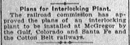 |
Left: The
Railroad Commission of Texas (RCT) gained authority to regulate rail
crossing safety in 1901. It promoted the use of interlocking plant
technology leading to a flurry of RCT-approved installations. Plans for
an interlocker at McGregor were reported by the Austin Statesman
on April
5, 1904. In January,
the Fort Worth Record and Register
had reported that a new Union Depot was being planned for McGregor
..."something badly needed." During the depot planning phase, Santa Fe
received approval to
integrate the manned interlocking tower into the new depot. Tower 56 was
commissioned for operation on October 22, 1904, but whether
the Union Depot also opened at that time (or perhaps was already in use) has not been
determined. Santa Fe had opened a
union depot with an integrated interlocking tower three months earlier at Morgan,
44 miles north of McGregor. A decade later at Milano,
Santa Fe built a union depot with an integrated interlocking tower to
replace
a depot and a stand-alone interlocking tower. |
Whether Santa Fe was leading the initial design of the
new McGregor Union Depot is undetermined, but once RCT permission was granted for Santa
Fe to lead the construction project for the new tower, it is no surprise that
an integrated tower with Santa Fe architectural stylings was incorporated into
the depot design. RCT's list of active interlockers
dated October 31, 1904 states that Tower 56 had opened nine days earlier with
a 24-function electric interlocking plant. Rather than employing the
manufacturer to install the plant, Santa Fe performed the installation itself,
a relatively new approach for Santa Fe but something SP had done frequently. The GC&SF had conducted its first
interlocking tower installation at Tower 50 in
Morgan only three
months earlier. The GC&SF had also installed interlocking plants at
Wallis and Cameron
within a day of the Morgan installation.
The 24 functions in the McGregor
plant consumed the full capacity of the interlocking machine spread over
eighteen working levers. A typical minimal manned interlocking required twelve
functions, so the plant's higher function count implies that it controlled
signals, switches and derails associated with sidings and connecting tracks
between the two railroads. The
McGregor crossing had existed long before 1901 when RCT began regulating
crossing safety, hence the railroads were required (by RCT regulation) to pay
equal shares of the capital cost of the tower and interlocking plant. The
recurring costs for operation and maintenance were shared on the basis of each
railroads' function assignments as a percentage of the interlocking plant's
total function count. RCT documentation lists Santa Fe with the responsibility
to staff the tower, and it undoubtedly took the corresponding lead for
maintaining the tower and the plant. Santa Fe would bill the Cotton Belt
periodically for its share of recurring labor, materials and utility costs.
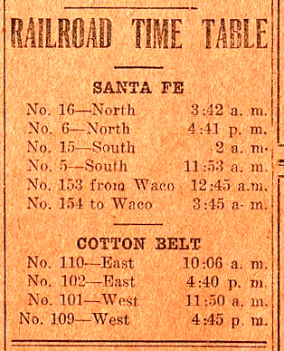 |
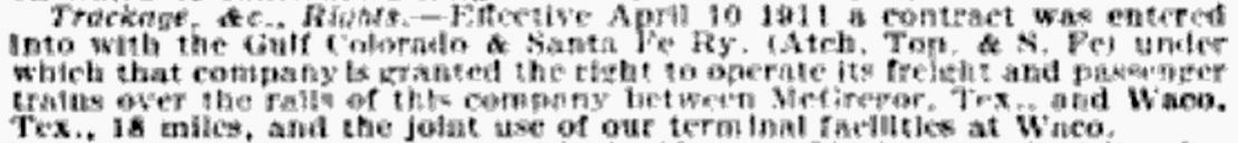
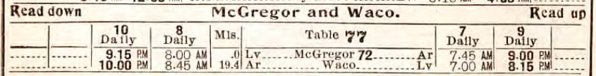
Above:
The first passage (upper) is
extracted from a SSW corporate report reprinted in the
Commercial & Financial Chronicle of
September 30, 1911. It notes that as of April 10, 1911, the GC&SF had
contracted to operate trains "over the rails of this company" (Cotton
Belt) into Waco including use of the Cotton Belt freight and
passenger depots at Waco. The lower
graphic shows that passenger service to Waco appeared in a Santa Fe system-wide Public Timetable dated May 26, 1912. The
extent of this service remains undetermined.
Left: This ad
in the McGregor Mirror of
January 13, 1928 shows service to Waco continued at least into 1928. The
last nightly train arrived from Waco at 12:45 am and returned to Waco at
3:45 am. Either Santa Fe paid the Cotton Belt to haul this train, or
Santa Fe kept a switcher at Waco during the day, perhaps to conduct
freight operations between the two towns. |
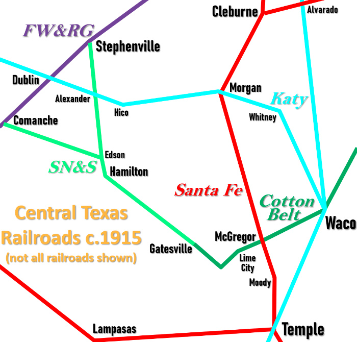
The
Stephenville North and South (SN&S) Railway was chartered in 1907 to
build 43 miles from Stephenville south to Hamilton. Hamilton was only 32
miles from Gatesville, so in 1910, the Cotton Belt bought the SN&S and
extended its tracks to Gatesville, expanding Cotton Belt operations to Hamilton and Stephenville. A 32-mile
extension west to Comanche was completed in 1912, departing the Hamilton
- Stephenville tracks at Edson five miles north of Hamilton. At
Comanche, the Cotton Belt connected with the Fort Worth & Rio Grande
(FW&RG) Railway (which became a Santa Fe property in 1937.) This was
the farthest west the
Cotton Belt operated along this line.
Right: map of area railroads c.1915, not
all railroads shown
The Cotton Belt tracks from
McGregor to Gatesville took a 27-mile circuitous route to cover a
straight line distance of only 19 miles. In part, this was to avoid
multiple crossings of the Leon River (although two were needed) but it
also facilitated service to Lime City where a lime production facility
operated for many years beginning in the 1880s. Continuing west, the
route veered south, apparently seeking easier terrain, but it also
passed through Leon Junction where it made a sharp turn to the northwest
to proceed into Gatesville. The Leon River was nearby, but there was no
"junction" at Leon Junction. A rail line from Lampasas northward had
been proposed, and enterprising landowners apparently pitched Leon
Junction as the crossing point with the Cotton Belt. The Cotton Belt
complied but the line from Lampasas was never built. The Cotton Belt
tracks were laid decades before the development of the massive Fort Hood
U.S. Army base which has a northern border nearly to Gatesville. At
least one spur into the base was built off the Cotton Belt.
Southern Pacific (SP) acquired control of the Cotton Belt
in the early 1930s. Though SP was in the process of merging its Texas and
Louisiana lines under the Texas & New Orleans (T&NO) Railroad,
the Cotton Belt was omitted from the consolidation. Shortly after the SP
acquisition, the dismantling of the SN&S tracks beyond Hamilton began.
By the end of 1934, the only track segment still officially owned by the
SN&S was the line from Gatesville to Hamilton. It remained in service
until 1942 and was then abandoned, the last vestige of the SN&S. Cotton
Belt service continued to Gatesville for another thirty years. In 1972,
the Cotton Belt tracks were abandoned west of Lime City. |
 |
The Bluebonnet Ordnance Plant opened in 1942
at McGregor to manufacture various munitions for the U.S. during World War II.
The plant was served by both railroads. Production ceased in 1945 and the
facility began producing solid rocket propellants. Over time, auxiliary
facilities were built in the area for similar purposes,
including rocket engine testing. One of the facilities has become the Rocket Development and Test Facility for
SpaceX but it is no longer
served by rail.
In 1972, the Cotton Belt tracks were abandoned beyond
Lime City. It remained the end of the line until 1989 when
SP service to McGregor and Lime City was terminated and the tracks were mostly
abandoned between Atco (on the western outskirts of Waco) and Lime City. Some
trackage remained in place near Tower 56 and was sold to Santa Fe so they could
serve industries in McGregor that had been served by SP. The impetus for SP's
curtailment of service west of Waco was the 1988 abandonment of the Cotton Belt
tracks from Corsicana to Waco. Two other SP
connections to Waco had already been dismantled (at
Giddings c.1959, and at Bremond c.1965.) The Corsicana line had been the only remaining connection
at Waco with SP's rail network. SP's tracks at Waco and the branch to Lime
City became stranded.
Bradley Linda explains how SP continued operating
its Cotton Belt lines in Waco. The key was trackage rights on MP, which had been
acquired as a wholly-owned subsidiary by Union Pacific (UP) in 1982.
"After the Waco-Corsicana abandonment, SP built a
'freight connector' between the north end of the SSW yard and the former MP
tracks near Orchard Lane. They ran the MP down to Valley Jct. then over to
the SP yard in Hearne, and vice versa. In the 90's
there was quite a lot of business on the East Waco - Atco segment, Warren Flour
downtown, and a plastic flower pot place and Gulf States Paper between New Road
and Valley Mills Dr. next to Franklin. Gross-Yowell Lumber got loads of lumber on the 'Westview team' next to McCoys. There was a diaper manufacturer, a
beer distributor, and several other customers, but the big customer was the
Lehigh White Cement Co. at Atco (formerly Atlas-Portland Cement.)"
In the early 1990s, SP began cleaning up its balance
sheet in anticipation of financial consolidation in the railroad industry. One
such step was to merge the Cotton Belt fully into SP, retiring the separate SSW
corporation. The demise of the Cotton Belt nickname was unfortunate; it
had represented an active railroad since 1881. In the
mid-90s, UP acquired SP. This gave UP the Waco-area Cotton Belt tracks
out to Atco, site of the cement plant (which UP still serves.) McGregor remains on the
Santa Fe main line, now operated by
Burlington Northern Santa Fe (BNSF) as a result of the mid-90s merger
of AT&SF with Burlington Northern.
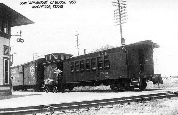
Above Left: Westbound Cotton Belt caboose at McGregor
Union Depot, 1953 (photo by H.D. Conner, hat tip Mark Nerren)
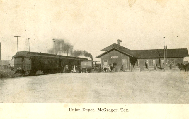
Above Right: This vintage
postcard shows an eastbound Cotton Belt train stopped at
McGregor (Steve Goen collection.) Maintaining the crossing diamond
at McGregor was no longer required when the Cotton Belt line to Waco was
severed. The Cotton Belt tracks that were sold to Santa Fe were converted to
industrial leads accessed by connecting tracks from the Santa Fe main line. The
east lead runs approximately 1.5 miles; the west lead runs about 0.5 miles. All
tracks are now owned and operated by BNSF.
 |
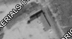
Left: McGregor
Union Depot was rebuilt in 1967 without Tower 56. Employee timetables
issued by the railroads soon thereafter do not give any indication that the interlocker was converted to an automatic plant,
suggesting that it continued to be operated manually by depot staff. (H.
D. Connor photo, courtesy J. D. Connor)
Below: ((c)
historicaerials.com) aerial
imagery of McGregor Union Depot before the rebuild (1964) with tower
roofline barely detectable
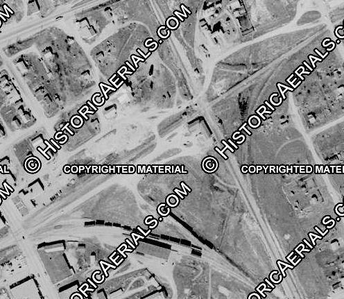
Below: aerial
image, 2025 (Google Earth)
 |
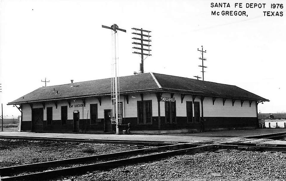
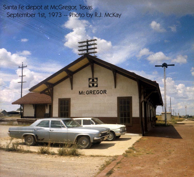
Right: This photo of the Santa Fe depot at
McGregor was taken in 1973 by R. J. McKay. The hut visible in the
background adjacent to the crossing appears to be the type of
concrete cabin commonly used for interlocking plants
in Texas (e.g. Tower 179,
Tower 200, Tower
204, etc.)
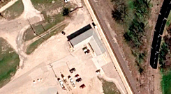
Below: This 1958 image ((c) historicaerials.com) shows
that the primary interchange yard was behind the depot with multiple
tracks. There was also a connecting track in the east quadrant
across from the depot. Both connectors remain intact to service local
businesses but recent ground imagery suggest that the tracks behind the
depot are used infrequently.
 |
 |
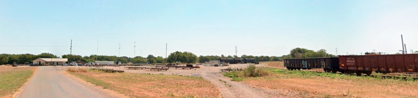
Below: Looking east in
July, 2023, Google Street View captured these railcars on the tracks behind the
McGregor depot (visible at far left.)
Research by Santa Fe historian William Osborn has
uncovered some interesting details pertaining to McGregor extracted from Santa Fe
Operating Bulletins:
Avoid
standing engines by cotton platforms. Beware Cotton Belt engines burning coal at
McGregor (undated, c.1920)
Only trains 25 and 26
shall take water at McGregor, except in emergency and in such case only take
enough to reach Clifton. (March 17, 1932)
If train number 6 will arrive
Cleburne 15 or more minutes late, wire Fort Worth from McGregor giving count of
Dallas revenue passengers separated as between coaches and sleeping cars. (Jan.
27, 1934)
When you are arriving McGregor on Train 38 as late as 5:00 p.m.
and having cars to set out that interchange with the Cotton Belt, you will
please leave the waybills with the operator at the telegraph office. (July 30,
1938)
When No. 38 picks up cars at McGregor for Cleburne, please wire the
yardmaster at Cleburne at first open telegraph office after leaving McGregor,
the numbers and initials of such cars that you pick up at McGregor. (March 31,
1939)
Conductors on No. 39 will stop at McGregor and pick up south loads
without being instructed to do so by message. (Apr. 28, 1939)
Speed of
passenger trains restricted to 50 mph and speed of freight trains restricted to
40 mph over Cotton Belt crossing at McGregor. (Apr. 25, 1941)
Mail for
Valley Mills on #5 will be handled thru to McGregor where it will be returned to
Valley Mills train 6, excepting when #5 is late and there is not time to handle
this mail thru to McGregor and get it transferred to #6, then #5 will stop at
Valley Mills for the unloading of this mail. (Oct. 3, 1941)
In setting
out loads at McGregor consigned to Bluebonnet Constructing Company, you should
leave waybills with operator at tower only when the freight office is closed.
(June 18, 1942)
When making movements over highway crossing between our
main track and Shell Plant [Bluebonnet Ordinance] just south of McGregor, a
trainman must be stationed on this highway to protect highway traffic before
movement started over it. (Nov. 3, 1942)
When freight conditions are
required to set out or pick up at McGregor conductor will leave train clear of
interlocking circuit while performing this service. (May 13, 1943)
In
interchanging of cars with Cotton Belt Railway at McGregor, we will deliver to
this railroad on track No. 3, Cotton Belt Railway will deliver to us on Track
No. 2. (July 15, 1943)
We have received serious complaints from
Bluebonnet Ordinance plant, McGregor, officials that some of our crews are using
fusees to pass signals and leave them on end of cars burning, many times when
car of high explosives in area. Please discontinue use of fusees while inside
of area and when necessary to flag highway crossing entering area do not place
fusees on cars. (Sept. 29, 1943)
Effective Oct. 29th, we will
discontinue going inside of the Bluebonnet Ordnance plant at McGregor with our
locomotives for the purpose of pick up, set out or switching. Hereafter we will
receive and deliver all cars, empties and loads, just inside of area gate. (Oct.
26, 1945)
Effective at once, the speed of passenger trains is restricted
to sixty (60) MPH over MK&T crossing at Morgan and Cotton Belt crossing at
McGregor. Speed of freight trains is restricted to forty (40) MPH over these
crossings. (April 18, 1946)
In stopping to pick up and do other
switching at McGregor, leave your train outside of home signal limits to avoid
blocking Cotton Belt crossing at McGregor. (Feb. 27, 1948)
The A&M
College is using the ground within the Bluebonnet Area, McGregor, for pasture
and have a number of high-priced cattle therein. They have provided a wire gate
across the tracks leading into the area which must be kept closed to prevent
cattle from getting onto the highway. Train crews will please see that gate is
properly closed after using to prevent cattle getting out. (Oct. 21, 1948)
Conductor train 16 will arrange to file daily wire report from McGregor to
Stationmaster Ratliff at Ft. Worth advising whether or not he has Dallas
passengers, and if so, how many. This message must be filed daily regardless of
whether or not there are any passengers for Dallas. (Nov. 28, 1955)