Texas Railroad History - Tower 157 - Blessing
Crossing of the Galveston, Harrisburg & San Antonio
Railway and the
St. Louis, Brownsville and Mexico Railway
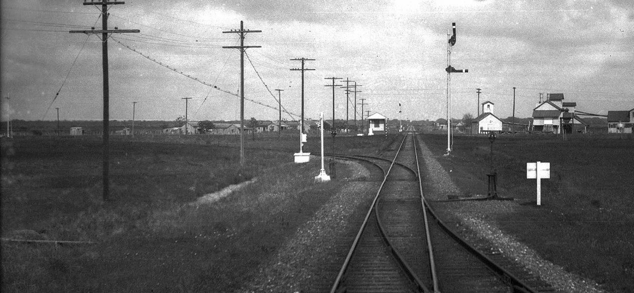
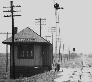
Above: Looking out on tracks
built by the St. Louis, Brownsville & Mexico (SLB&M) Railway at least
thirty years earlier, John W Barriger III snapped this photo from the rear of his business car
as he viewed the junction his train had just passed over at Blessing. Barriger is facing east-northeast
on a trip in the late 1930s or early 1940s as his Missouri Pacific (MP) train
heads generally south toward
the Rio Grande Valley. MP had acquired the SLB&M in 1925, and in
Barriger's day, operations were handled by MP trains although the SLB&M
owned the tracks as a subsidiary of MP. The small white cabin with the window
sitting trackside on the left houses the Tower 157 interlocking plant and its
controls. The plant managed MP's crossing of Southern Pacific (SP) tracks which
are barely visible in front of the window from this view. To the
right (south) SPs tracks went to Palacios while those to the left (north) went
to Bay City, the town through
which Barriger's train had passed a few minutes earlier. MP's line carried
substantially more traffic than SP's, hence the interlocker was operated by SP train
crews when they needed to cross the MP tracks. The signals would otherwise be
set to allow unrestricted movements on MP's line.
 |
In the foreground of Barriger's photo,
notice the switch for the SP transfer track veering off to the left, into the
northwest quadrant of the crossing. The transfer track switch is followed
closely by another switch that Barriger's car has just
passed over leading to the MP passenger depot that will soon be in his
view off the right side of the car.
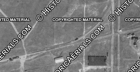
Left: This
1930 aerial image ((c) historicaerials.com) shows the white Tower 157
cabin sitting in the northeast quadrant of the crossing casting a short
shadow to the north. A county road is visible west of the SP tracks
paralleling them through town. What appears to be a single locomotive is visible
on the transfer track close to the switch for the MP main line. As
Barriger's photo shows, there were two switches in succession on the MP
tracks a few yards apart. The switch farther east connected to the
interchange track; the other switch connected to the depot lead for the
MP passenger station which is visible (lower left) on the south side of the MP main line. |
| Right:
From Barriger's distance, the cabin appears larger than a typical cabin,
and it resembles this one he photographed in San Marcos on another trip, Tower 206.
Archived records of the Railroad Commission of Texas (RCT) maintained at DeGolyer
Library, Southern Methodist University, indicate that the Tower 157
cabin was installed in the northwest quadrant of the crossing, yet the
1930 imagery clearly shows it to be in the northeast quadrant. Perhaps a hut was built in the northwest quadrant as a temporary structure to
house the interlocking plant and controls while the larger cabin was erected across
the tracks. |
 |
Grateful for the New York, Texas & Mexican Railway choosing to build through
his land in 1903, J. E. Pierce settled for Blessing as the name of the new
town he was promoting after the Post Office rejected his first choice, Thank
God. The railroad, owned by Southern Pacific (SP) and subsequently merged into SP's
Galveston, Harrisburg & San Antonio (GH&SA) Railway subsidiary, was building from
Bay City to the town of Trespalacios on Tres Palacios Bay. Soon renamed
Palacios, the town had paid a bonus to SP to attract the rails. In 1905, Blessing
was blessed with
additional rail service when the St. Louis, Brownsville & Mexico (SLB&M)
Railway crossed the GH&SA there as the railroad built a major line between
Brownsville and Houston. Despite
being a crossroads of two rail lines, Blessing never grew much
beyond a few hundred residents.
An MP Employee Timetable (ETT) dated
April, 1929 notes the Blessing crossing as gated. Four months later, Railroad Commission of Texas
(RCT) records show Tower 157 authorized for operation on August 27th, but SP
documentation states the cabin was placed in service on May 1. The interlocker was a mechanical plant with a 12-lever control frame
(of which ten were used) installed in a trackside cabin. Four levers were used
for home and distant signals in both directions on the MP tracks. Four more
levers were used for derails, one in each direction on both tracks. Two were
used for facing point locks that controlled switches at both ends of the interchange track.
The SP line did not need signals; fixed warning signs were sufficient because SP trains
always stopped at the diamond to dispatch a
crewmember to enter the cabin and change the controls to allow the train to cross,
reversing them afterward. The interlocker
was mechanical, but it incorporated power-operated distant signals, probably
because of the distance involved. MP's main line had heavy freight trains
operating at higher track speeds, requiring distant signals to be further from
the diamond so that trains could slow to a stop when encountering a STOP signal.
A
modification to the interlocker was authorized by RCT on July 18, 1941. The
August, 1941 issue of Railway Signaling &
Communications described the change as "Modification of No. 157 at
Blessing, Tex. at crossing with M. P., involving relocation of 2 approach
signals and removal of 2 main-track derails on M. P." Another change was
authorized by RCT on August 10, 1948, but the details are undetermined. SP's branch line to Palacios was abandoned in 1985,
eliminating the need for the interlocker. The former MP line continues to
function as a major rail artery between Houston and the lower Rio Grande Valley,
currently owned by Union Pacific (UP.)
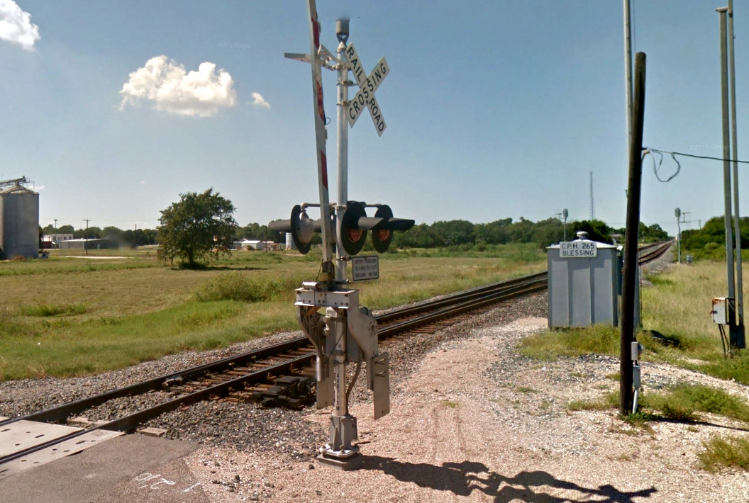
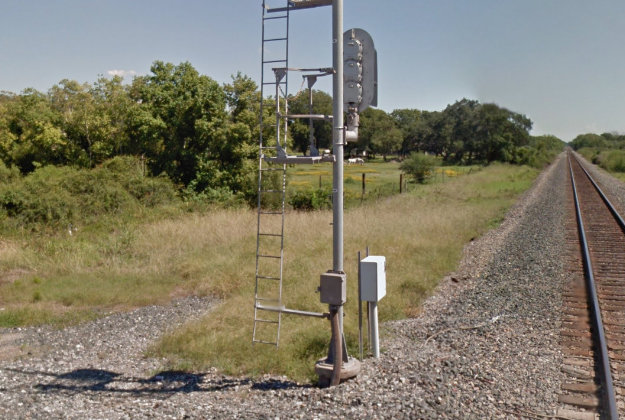
Right: This photo (Jim
King,
December, 2006) shows a metal pole on the north side of UP's former SLB&M
tracks immediately east of the County Road 482 grade crossing. The SP tracks
crossed just beyond the pole, and the cabin visible in Barriger's photo
would have been on the other side of SP's tracks.
Mounted atop the pole is a
metal box that formerly held pushbutton
controls for the electric interlocker that replaced the mechanical plant
originally installed. The date this change was made is undetermined. There
is, unfortunately, a gap of 23 years in aerial imagery between 1958 and
1981 during which the cabin was dismantled and the interlocker replaced.
The interlocker change can be dated to between 1977 and 1981 because a
MP Employee Timetable (ETT) from October, 1977 reports the interlocker
at Blessing as a mechanical plant, presumably with the cabin still
present.
A Southern Pacific ETT dated October 31, 1982 (below)
says that a pushbutton controller was in use, undoubtedly housed in the
control box atop this abandoned pole.
 |
 |
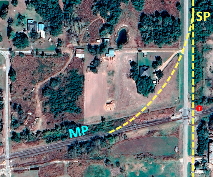 |
Left: This
2024 Google Earth satellite image of the crossing at Blessing has been
annotated to show the SP tracks (yellow) and the Tower 157 (red circle)
cabin location. There is no longer any visual evidence of the interchange track in the northwest quadrant;
it has been
plotted using coordinates from the 1930 aerial imagery. A siding now begins
immediately west of the County Road 482 grade crossing and continues
west; it did not exist in Barriger's day.
SP's
tracks to the north were straight for about four miles. The county road
beside it crossed over to be east of the tracks about 1.6 miles north of
Tower 157. Today at the crossover point, the road makes a gentle jog to
the east that northbound drivers would hardly notice. Originally, the road
crossover was implemented with two 90-degree turns. From there, the tracks continued
north for a couple of miles and then curved to the east
toward Bay City. SP's line ultimately terminated at
Wharton. |
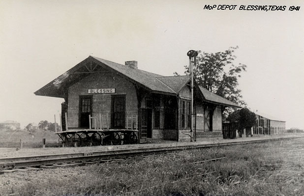
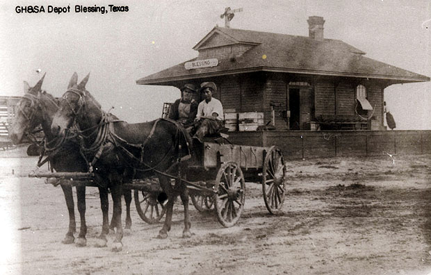
Above Left: A siding begins a short distance west-southwest of the Farm Road 482 grade
crossing. It was not present in Barriger's day. Above Right: In the opposite direction, the interlocker control pole
in the 2006 photo is no longer standing. Below
Left and Right: These uncredited photos from the
Blessing page at usgenwebsites.org show the MP and SP depots at Blessing.
The SP line was built first before the town existed, hence the station was
effectively "downtown" as the town built around it. The SLB&M line built a few
years later passed north of town where open land for the right-of-way would have
been less expensive to acquire.