Texas Railroad History - Tower 203 - Dublin
A Crossing of the Gulf, Colorado & Santa Fe Railway and the
Missouri - Kansas - Texas Railroad
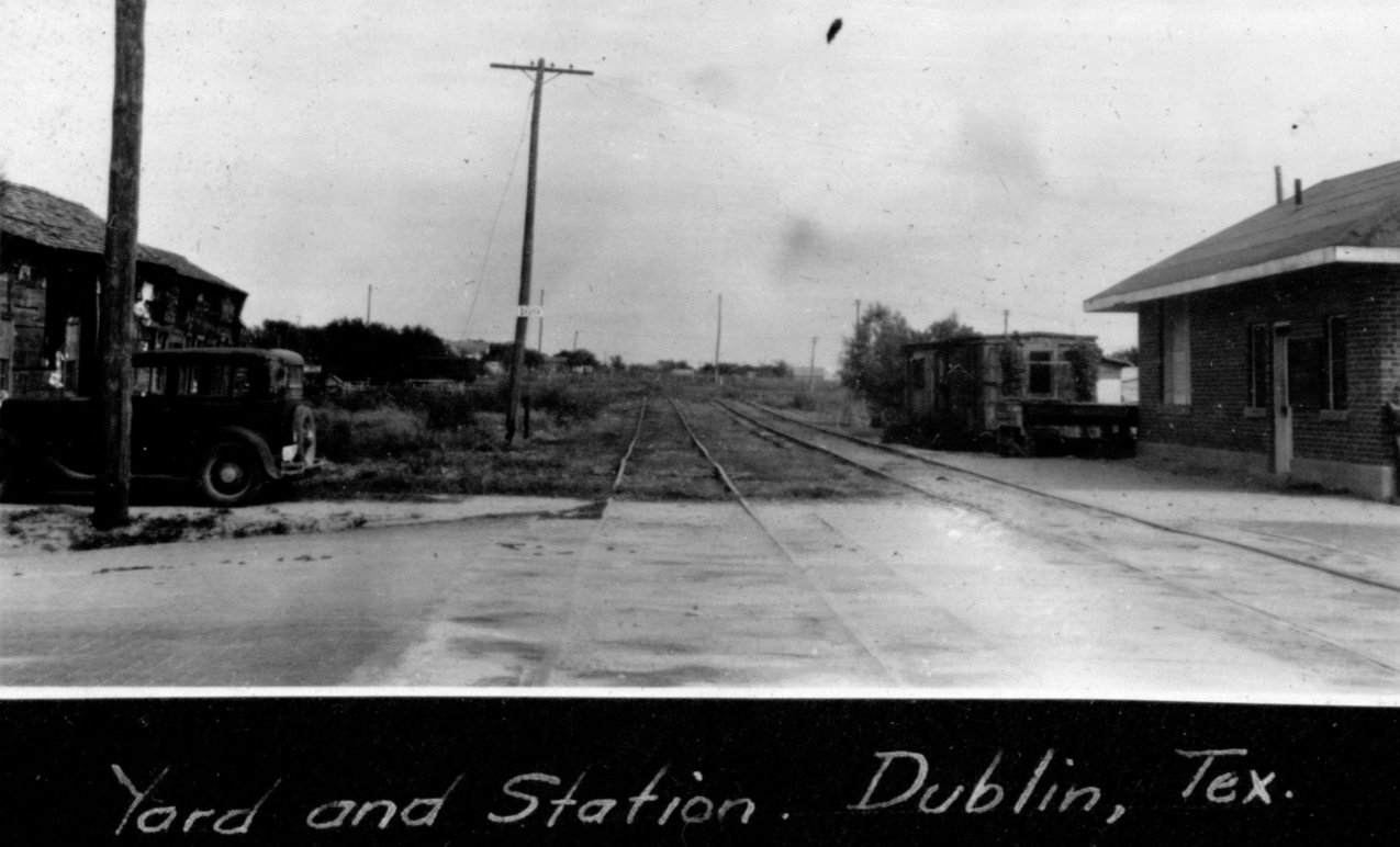
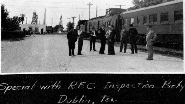
Above: John W. Barriger III
was the head of the railroad division of the Reconstruction Finance Corporation
(RFC) when he snapped this photo in Dublin on October 1, 1940, having reached
the southern terminus of his trip inspecting the Wichita Falls & Southern (WF&S)
Railway. The photo was taken facing due east from the west edge of Grafton St.
(note brick pavement at lower left.) The view is along the WF&S tracks toward
the main track of the St. Louis San Francisco Railway which ran north/south a thousand feet in the
distance. Barriger is diagonally across from the small, brick WF&S station that sat south
of the main track on the east side of Grafton St. The white sign on the utility
pole ahead reads "169", presumably a milepost marker for the end of track
distance from Wichita Falls. The WF&S yard was small and most of it was within
the two street blocks immediately behind Barriger. (all John W Barriger III
photos on this webpage provided courtesy John W. Barriger III National Railroad
Library)
By the time Tower 203 was commissioned in Dublin by the
Railroad Commission of Texas (RCT) in the mid-1950s, neither of the railroads
that originally established the junction were around to see it interlocked. The
crossing came into existence when the Fort Worth & Rio Grande (FW&RG) Railway
crossed the tracks of the Texas Central (TC) Railroad in 1890. The TC had built
through the area in 1881, heading for northwest Texas out of Ross. Ross was the
northern terminus of the Waco & Northwestern (W&NW) Railway, a subsidiary of the
Houston & Texas Central (H&TC) Railway. As early as 1871, while the H&TC
was building its main line from Houston to the
Red River, investors had wanted to start
a branch line into the Texas Panhandle. They acquired the dormant Waco Tap
Railroad for that
purpose, renaming it to be the W&NW and building it from Bremond to
Waco
to Ross in 1872. After a delay of several years during which steamship magnate
Charles Morgan acquired the H&TC, the investors elected to proceed northwest
out of Ross under a new charter, the Texas Central.
The TC's construction
commenced from Ross in 1879, went north to cross the Brazos River west of the new town of Whitney
(named for H&TC President Charles Whitney), and continued west into the new town of
Morgan (named for Charles Whitney's father-in-law, Charles Morgan, recently
deceased.) Farther
west, the tracks passed near enough to Hico that the community relocated a
couple of miles to be trackside. About twenty miles west of Hico, the tracks
bypassed the community of Dublin, much to the disappointment of the locals. This
was not unusual; like most railroads, the TC preferred to create its own towns
where it would own all of the surrounding land rather than convey the benefit of
railroad service to an existing community (unless, of course, they were willing
to pay handsomely.)
Dublin dated to before the Civil War, and by 1874, it had a post office and
stagecoach service. The TC needed a water stop, as they were now more than
twenty miles beyond Hico, but they elected to create their own town, passing
north of Dublin and stopping a few miles farther west near the county line between Erath and Comanche counties.
There, the new
town of Mount Airy was surveyed and town lots were sold on December 31, 1880. In
addition to the 48 city blocks initially platted, another 72 blocks were
surveyed. Mount Airy's plat was atypically large (e.g. only 33 city blocks platted for De Leon, the next town
to the west) suggesting that the TC expected Mount Airy to become the premier city of
the region. It was about midway between the county seats of Stephenville (Erath County) and
Comanche (Comanche County), much to the chagrin of both since neither had a
railroad at the time. But railroads can't buy up all the land they pass through,
so there was plenty available near the rails. The folks in Dublin created a new
townsite along the TC, about four miles east of Mount Airy, and relocated their
entire community. (Dublin's former site became known as "Old Dublin", for which
a cemetery remains in operation at 32 03 52N, 98 20 07W.) There was one big
problem, however: Mount Airy was a railroad stop and Dublin was not. Relocating
trackside is of no benefit if the trains don't stop. Perhaps the locals
knew something that the TC didn't? The battle between Mount Airy and Dublin had
just begun.
 |
Comanche was about twenty miles southwest of
Mount Airy. It
had been the main town in the area since before the Civil War, with a
post office, daily stage service and a newspaper. But in 1880, Comanche
didn't have a railroad, and there was concern among its citizens that
Mount Airy would become the new trade center for the region. Comanche
had tried
to induce the TC to build farther south, to no avail. The
Comanche Chief newspaper had little
good to say about Mount Airy, although these two articles published on
March 19, 1881 are fairly objective. Dublin, already with several stores
and a newspaper, had relocated trackside to compete with Mount Airy, hoping to become a rail stop. Somehow, within ten years, Dublin had won, and
Mount Airy was little more than "a sheep pasture" (Fort Worth Gazette,
July 29, 1891.) Despite the TC's grand plans, Mount Airy never developed
beyond a tiny residential outpost. Yes, Dublin was slightly closer to
Stephenville than Mount Airy, but that hardly seems a difference maker.
One reported theory holds water: water was hard to reach in Mount Airy
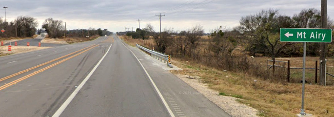
with the hand-dug wells of the time. The sign
below, four miles west of Dublin on State Highway 6, shows
you how to get to Mount Airy, but there's
not really any "there" when you get there! (Google Street
View, December, 2021)
 |
 |
In early 1881, the TC resumed construction from
Mount Airy, heading generally northwest and creating the new towns of De Leon (that's a long "Dee" for
you outsiders) and Gorman. Gorman was just over the line into Eastland County,
about fifteen miles from the town of Eastland, the
county seat. But...following the pattern...the TC skipped Eastland and created the new town of
Cisco instead. Tracks continued
north and reached Albany by the end of 1881.
Dublin soon got its railroad depot
and Mount Airy's eventually closed. With the presence of the TC, Dublin's
population boomed from 264 to 2,025 residents by 1890. While Dublin fared well,
the TC did not, entering receivership in 1885. After Court supervision for six
years, the TC was sold to a committee of bondholders who then deeded the TC main
line and associated assets to a new Texas Central Railroad Company in January, 1893. The
new company added tracks from Albany to Stamford (1900), Stamford to Rotan
(1907), and De Leon to Cross Plains (1911.) In 1910, the Missouri - Kansas -
Texas (MKT, "Katy") Railroad acquired 90% of the stock of the TC. They did not,
however, take control of the company until May 1, 1914 when the TC was leased to
the Katy's Texas-based subsidiary. This enabled the Katy to comply with state
law regarding railroad ownership since it was not a Texas corporation. The Texas
Central name continued to be used, but "MKT" and "the Katy" came into common
parlance as TC operations continued for several decades. In 1967, the Katy
abandoned most of the line between Ross and Albany. The tracks between Dublin
and Gorman were retained because they served a substantial peanut growing and processing area
that had evolved after 1906 when farmers, tired of fighting the boll weevil, had
switched from cotton to peanuts. Another new Texas Central Railroad company (a.k.a
"the Peanut Line") was formed to own and operate the route.
Of course,
the Peanut Line needed a connection to the national rail network, and that
connection was supplied at Dublin. Despite gaining a second railroad in 1890,
Dublin had not overtaken the nearby county seats of Stephenville and Comanche,
but only because the new railroad also went to those towns (which had previously
lacked rail service.) The new line was the Fort Worth & Rio Grande (FW&RG)
Railway, chartered in 1885 by
Fort Worth interests to build southwest to Brownwood. The objective was
to tap a vast area of livestock production to capture shipments to Fort
Worth where four rail-based stockyards would open in 1886, and the Union Stock
Yards would open north of the Trinity River in 1889. Fort Worth was becoming a meatpacking
center and cattle were needed to keep the production lines
running. The FW&RG construction was
slow and had only reached Granbury, forty miles from Fort Worth, by the end of
1887. Another 46 miles to Harbin was completed over the next two years, and
Dublin (five miles from Harbin) was entered on March 1, 1890. There, the FW&RG
made a junction with the TC and continued southwest, reaching Comanche by the end of
1890. The final thirty miles into Brownwood was built in 1891.
The FW&RG
charter had been amended in 1887 to permit an extension from Brownwood to
Kerrville, farther into livestock territory, but this construction did not begin
until 1901. By then, the FW&RG had been acquired by the St. Louis San Francisco
(SLSF, "Frisco") Railway, a large midwest railroad that was rapidly expanding
into Texas under the auspices of its Chairman, native Texan Benjamin
Franklin Yoakum. In his reference tome, A History of
the Texas Railroads (St. Clair Publishing, 1941), the dean of Texas
railroad historians, S. G. Reed, asserts that the FW&RG was "built by the
Frisco", presumably by direct involvement with the investor group, but
Reed does not specify. If so, it
was well before
Yoakum's tenure as he did not become General Manager of the Frisco until 1897.
(There was, however, a precedent for this approach with the
Paris & Great Northern.) As a Frisco subsidiary,
the FW&RG extension to Kerrville reached Brady by the end
of 1903 and stopped. Several years later, an extension south from Brady to
Menard was built, but the line never went any further.
 |
At Brownwood, the
FW&RG crossed a Gulf, Colorado & Santa Fe (GC&SF) line that went as
far west as San Angelo from Santa Fe's base at
Temple. There was also a 6-mile branch to Coleman
that departed the main line 25-miles west of Brownwood. Santa Fe had
built the line incrementally west to Lampasas in 1882, continuing to Brownwood in 1885
and
on to San
Angelo by 1888. All of it was through a seemingly
boundless area populated by cattle and sheep, not people. By the time the
FW&RG reached Brownwood, the GC&SF had for several years been a subsidiary of
the much larger Atchison, Topeka & Santa Fe Railway which was pursuing expansion
throughout the southwestern U.S.
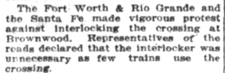
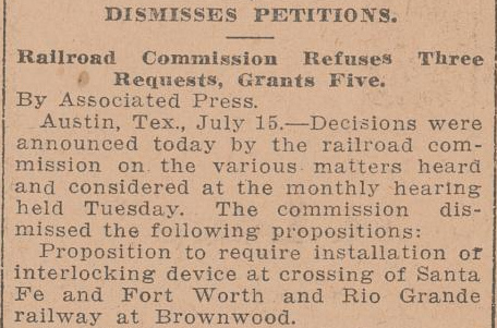
Left: The FW&RG / GC&SF grade crossing at Brownwood was
an obvious candidate for an interlocker. One was proposed by Santa Fe
but the FW&RG was adamantly opposed to the idea. RCT held a hearing on
the matter on July 14, 1914 to discuss the situation at Brownwood. The
next morning's Austin Statesman
(top) noted the
FW&RG's presentation to RCT opposing the interlocking. Later that same
day, the evening Galveston Tribune
(bottom) reported that
RCT had officially dismissed Santa Fe's petition to interlock the
Brownwood crossing. Whether a crossing gate was in place normally lined
against the FW&RG is undetermined, but it seems likely given the
objection that there were too few trains to justify a manned
interlocker. The fact that the crossing was near both depots may also
have influenced RCT's decision since in those days, trains usually
operated at low speeds near depots in major towns. A cabin interlocker
operated by FW&RG train crews would have been an appropriate solution,
but those were not authorized by RCT until the 1920s.
Santa Fe had vigorously opposed the FW&RG's
encroachment on its territory, yet the two railroads
also cooperated in surprising ways. Out of Brady, the FW&RG shared Santa Fe's
line to Eden as far as Homer Junction, where it split off to proceed south to
Menard. The companies also jointly handled many
livestock shipments, particularly as Fort Worth evolved to become a leading
meatpacking center. It was not uncommon for Santa Fe livestock cars to be
handed over to the FW&RG at Brownwood for transport to
Bird's Siding in Fort Worth where the cars would be handed back to Santa Fe.
The FW&RG route from Brownwood to Fort Worth was 117 miles shorter than Santa
Fe's competing route which required going first to Temple and then north to Fort
Worth on their main line. Time and distance were important for
livestock shipments because the law required railroads to perform feeding and
watering at specific intervals. Ultimately, it made sense for Santa Fe to own
the shorter route to Fort Worth, so they purchased the FW&RG from the Frisco in
1937. |
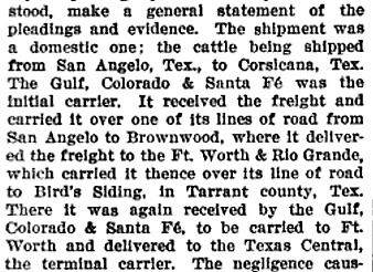 |
Left: This excerpt from court records of a 1902
damages lawsuit against both Santa Fe and the FW&RG shows how a cattle
shipment from San Angelo to Corsicana involved interchanges at both
Brownwood and Bird's Siding.
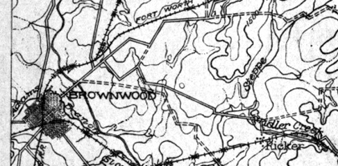
Right: This 1918 U. S. Army map of Brownwood and
vicinity shows the Santa Fe (east / west) and the FW&RG (north / south)
crossing on the southwest side of town. As noted earlier, RCT never mandated a numbered
interlocker for this junction. The line
branching off of the FW&RG north of town was the Brownwood North & South
Railway, an 18-mile track to May that had been
acquired by the Frisco in 1910. |
 |
By the time Santa Fe
acquired the Fort Worth - Brownwood line from the Frisco, the Katy crossing at
Dublin had already been gated, with the normal position allowing unrestricted
movement on the Katy. A Santa Fe operations bulletin issued for
Dublin on Aug. 25, 1937 states (quotations from notes and transcriptions
provided courtesy, William Osborn) "Please see that crossing gate is lined
against our line after pulling over", ("Pulling over" as in
pulling the train over the diamond, i.e. put the gate back in the normal
position after crossing!) Soon
thereafter, Santa Fe began preferring Fort Worth rather than Brownwood for
freight originating from intermediate points on the line, which helped minimize
movements across the diamond (although there may have been other reasons.) A bulletin dated June 26, 1939
required... "Any freight delivered to our line by WF&S at Dublin or
originated at Dublin for Beaumont, Houston, Galveston or intermediate points on
or via our line south of Ft. Worth, will be picked up by No. 48 and handled into
Ft. Worth, instead of routing via Brownwood." A July 26, 1949 bulletin
reminded trainmen that "The crossing gate at Dublin is to be left lined for
the MK&T, except when being used by our trains passing over it."...
presumably in response to complaints from the Katy.
Santa Fe had lots of
water problems along the Brownwood line.
A bulletin issued December 31, 1938 says "Do not take water at Dublin and
Stephenville, only in case of emergency, and then only enough water to make the
next water station." [Bad water at Dublin may explain the "R R
Water Treating Plant" that appears in the Katy yard on the 1934 Sanborn Fire
Insurance map of Dublin.] By January 20, 1940, Stephenville water was still
unsatisfactory but Dublin water was acceptable (or at least, it was better than
Stephenville's!) A bulletin of that date says "Water Station at
Plover (Dublin District) has been discontinued. Due to water at Stephenville
being unsatisfactory for boiler use, Southward trains will take full water tank
at Granbury and will not take water at Stephenville, except in emergency, and
then only in sufficient supply to enable the train to reach Dublin."
[Plover was in Tarrant County, southwest of Fort Worth; in July, 1952,
Santa Fe implemented a line change eliminating the
Plover station due to the looming impoundment of Benbrook Lake.] A bulletin
issued July 26, 1947 says northbound trains "...taking water at Dublin will
stop at the Katy crossing, cut off at that point, and handle the engine to the
water tank, leaving their train south of the Katy crossing. This to avoid the
blocking of street crossings at Dublin." Four months later, a November 7,
1947 bulletin advised "Account shortage of water, only take water at
Comanche in case of emergency and then only enough to make the next water
station."
On or about December 20, 1954, an automatic interlocker designated Tower 203
by RCT was
commissioned at Dublin. A bulletin of that date was issued stating "An
automatic interlocking has been placed in service at the M-K-T crossing, MP
86.2, Dublin District. Maximum authorized speed for trains thru the interlocking
is passenger 20, freight and mixed 20 miles per hour. Rule 606(c) Operating
Department 1953, governs. Control box locked with standard switch padlock
containing instructions is attached to side of concrete relay house next to the
Santa Fe track. The instructions therein are as follows: Governing signal
ordinarily clears if conflicting routes are unoccupied. When such signal
indicates "stop", a member of crew must precede movement to crossing; open the
control box; and punch the control button and hold for not less than ten
seconds. If signal cannot be cleared after the expiration of five minutes, train
may proceed protecting against conflicting movements."
In addition to the original FW&RG/Santa Fe junction at Brownwood, the FW&RG
and Santa Fe also crossed at Cresson, on the north end of the line near Plover. Santa Fe had passed through Cresson when they built 42 miles from
Cleburne to Weatherford in 1887. Acquiring the
FW&RG gave Santa Fe a shortcut from Brownwood to Dallas via
Cleburne. In 1959, Santa Fe abandoned the tracks between Weatherford and
Cresson, keeping the Cresson - Cleburne segment intact. They also abandoned the former FW&RG tracks south of Brownwood
that year.
Service south of Brownwood to Brady (and Menard) was still in place because Santa
Fe had their own track to Brady out of Lometa (about midway between Temple and
Brownwood) that had been built to compete with the FW&RG. The tracks from Lometa
to Brady remain intact today, but the extensions from Brady to Eden and Menard were abandoned in
1972.
By the late 1970s, Santa
Fe had begun to question the value of continuing to operate the
Fort Worth - Brownwood line. One unverified report says that in 1983, service was
suspended through Comanche (implying the Dublin - Brownwood segment, since the
Peanut Line was still operating into Dublin.) Santa Fe's situation with the
Brownwood line was not uncommon in Texas. There were plenty of
rail segments that were losing money or, at best, break-even, for which
maintenance and capital expenditures were hard to justify. This was particularly true in rural areas, which describes much of
Texas' geography despite its large population. In 1981, the Legislature responded.
This excerpt from a 2002 report by the
Texas Transportation Institute explains how:
The 67th Texas Legislature first
authorized formation of Rural Rail Transportation Districts (RRTDs) in 1981. The
U.S. Congress had passed the Staggers Rail Act in 1980, greatly reducing the
economic regulation of the railroad industry and some of the barriers to
abandonment of many unprofitable railroad lines held by large, Class I railroad
companies. Foreseeing a period during which the railroad companies would greatly
increase the number of abandonment requests for light traffic density branch
lines in rural areas, the legislature sought to create a mechanism that would
allow local governments to save rail as a rural transportation option.
The RRTD concept worked well, and a change in state law in 1997 allowed individual
counties to set up their own RRTD, primarily for
rail-oriented economic development as opposed to rail corridor preservation. This
greatly expanded the number of districts; there were 42 RRTDs as of June, 2013,
two-thirds of the which were single-county districts.
In the early 1990s, the Cen-Tex RRTD was formed
by the counties of Brown, Comanche, Erath, Hood and Johnson, the counties
through which the FW&RG tracks had built southwest of Fort Worth. The
objective was simple: find a way to acquire the Brownwood line to ensure its
preservation. The Cen-Tex RRTD in conjunction with a new entity, Cen-Tex Limited
Partnership, was able to acquire the line from Santa Fe in 1990. Cen-Tex RRTD
owned the land and right-of-way (which, as a government entity, made it exempt
from property taxes) while the Partnership owned the operating rights and the
infrastructure. In December, 1998, the Fort Worth & Western (FW&W) Railroad
leased the infrastructure and operating rights from the Partnership and began
operating the Brownwood line. They also operate the Gorman branch, hence, the FW&W now
uses
most of the rails that ever passed through Dublin.
There was one other
rail line into Dublin besides the TC/Katy and the FW&RG/Frisco/Santa Fe. As noted in the photo caption at the top of the page, the Wichita
Falls & Southern (WF&S) owned tracks into Dublin. They had been built by the Wichita Falls, Ranger and Fort Worth (WFR&FW)
Railroad which had been founded shortly after the
Ranger oil boom in 1917. The WFR&FW charter
was granted in September, 1919,
and 67
miles of track between Dublin and Breckenridge via Ranger was built soon
thereafter. In 1921, the WFR&FW built nine
miles farther north from Breckenridge to a junction known as Jimkurn. There, it
connected to the WF&S which was building
south that same year from Newcastle (where its tracks continued north to Wichita Falls.) The WF&S had rights on the WFR&FW from Jimkurn
into Breckenridge, and it subsequently bought the WFR&FW in the mid-1920s. The
WF&S continued operating the line, including the tracks into Dublin, which entered
on the
northwest side of town and curved due east parallel to (and a block north of) the Katy's tracks
into a
connection with the Frisco. The entire route was abandoned by the WF&S in 1954.
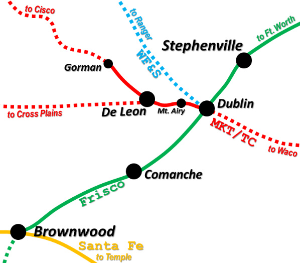
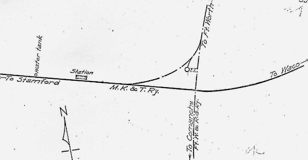
Above Left:
area map centered on Dublin (not all railroads shown)
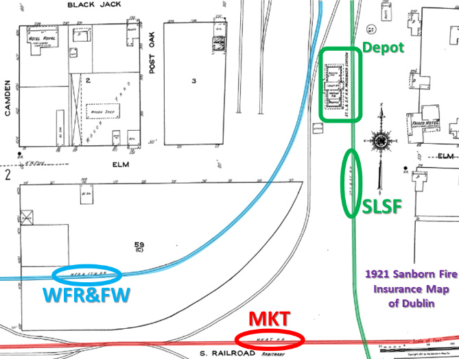
Above Right: This snippet from the 1921 Sanborn Fire Insurance map
of Dublin has been highlighted to show the relative locations of the three
railroads in the vicinity of the SLSF (Frisco) passenger depot, with the future
Tower 203 crossing at lower right.
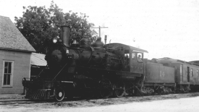
Above: As noted in the photo
at top of page, John W.
Barriger III visited Dublin on October 1, 1940 during an inspection trip on
the WF&S. These photos show the RFC inspection party and their special WF&S
train during the stop at Dublin.
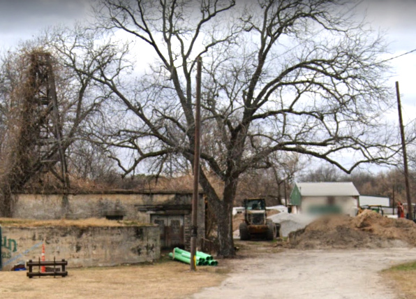
Right: Image
processing reveals that the light pixels inside the blue rectangle above
are the white shirt of a man wearing overalls. He is standing beneath an
awning in the doorway of the building behind the reservoir,
approximately at the far end of the green pipe in the 2021 Street View
image. |
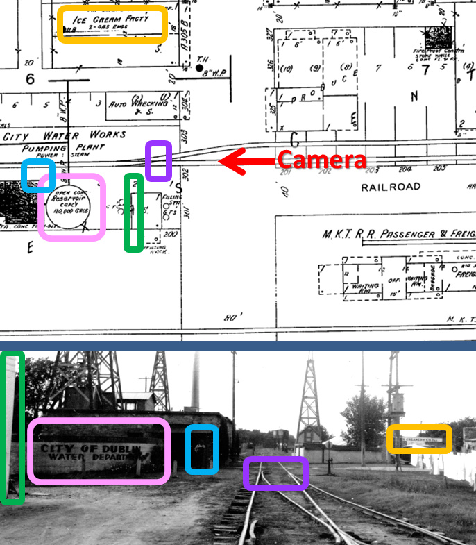
This 1934 Sanborn Fire Insurance map (left)
and a photo Barriger took during his 1940 trip (bottom
left) correlate nicely. The camera is on the west side
of Patrick St. facing west along the WF&S main track. Directly in front is
the switch (purple)
for a spur that went to the Frisco
tracks 1,400 feet behind Barriger. The back edge of a "Filling Sta." (green rectangle)
is visible, but more prominent is the reservoir for the
City Water Works (pink rectangle.) To the right, the
cartographer shows an "Ice Cream Fact'y" (orange rectangle), but in
the photo, its "n Creamery Company, Inc." -- the full name is occulted by other
objects. Note from the map that the back side of the Katy depot was behind and to the
left of Barriger. Below:
Some 81 years after Barriger's visit, this
December, 2021 Google Street View shows that the water reservoir and the
building behind it remain intact.
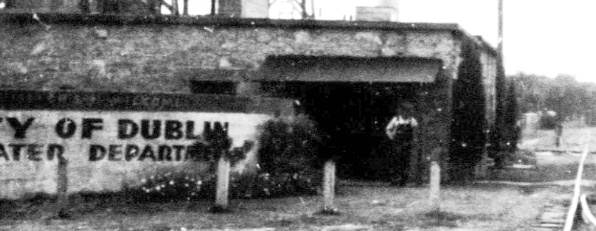 |
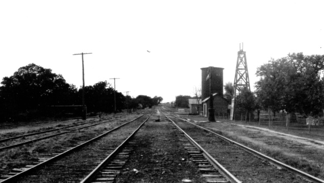
Above Left: Standing on Patrick St. one block south of
the WF&S tracks, Barriger captured this image of the western part of the Katy yard.
The depot is behind him, to the right. The cylindrical tower is identified on a 1934 Sanborn Fire
Insurance map as a "W. T." (water tank) associated with the building in front of
it, identified as "R R Water Treating Plant". The building behind the
cylindrical
water tank did not exist in 1934. The derrick, and the small building beneath it, are
identified on the map as "City Deep Well and Pump".
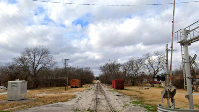
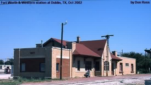
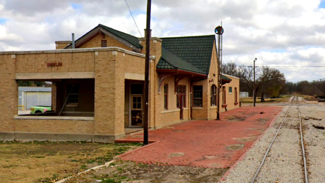
Below Left: the Katy depot at
Dublin (Don Ross, 2002) Below Right: This Katy depot image was captured by
Google Street View in December, 2021. The former Katy track in the distance
curves north to join the line to Fort Worth.
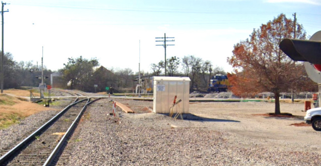
Above Left: This December, 2021 Google Street View looks
south from the Black Jack St. grade crossing down the former Santa Fe tracks showing an FW&W locomotive on the
west connector in the distance. The equipment cabin in the center of the image
is midway between Black Jack and Elm Streets, placing it near the middle of the
former Frisco passenger depot. Frisco's delay in building a decent passenger
depot caused enough public
outcry that RCT issued an order on January 13, 1909 requiring the Frisco to build one.
Above Right: This 1915 track
chart of Dublin from the Office of the Chief Engineer of the Katy railroad shows
the location of the Katy depot, and that there was a turntable off the connecting track. No evidence has been found of connectors in any of
the other three quadrants. Below Left:
One block farther south than above, this September, 2013 Google Street View
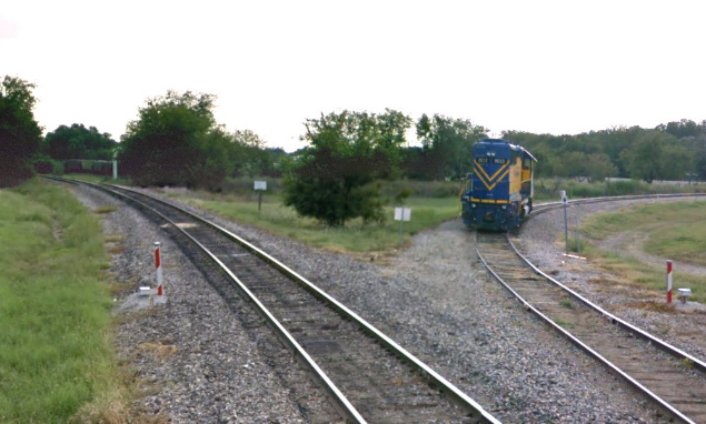
looks south from the Elm St. grade crossing. FW&W locomotive #2012 "Chaparral"
is on the connecting track that leads west onto the former Katy tracks to De
Leon and Gorman. The railcars visible in the distance are on an industry siding.
The FW&RG crossing
of the TC would have been visible in this view.
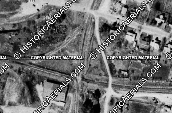
Below Right: This image ((c)historicaerials.com) was
taken in 1964, three years before the Tower 203 crossing was removed. The Elm St. grade
crossing is visible top center. The faint rights-of-way visible in the upper
left corner are remnants of the WF&S spurs and connecting track that went behind
the Frisco passenger depot north of Elm St.