Texas Railroad
History - Tower 175 - Etter
A Crossing of the Chicago, Rock Island & Pacific Railway
and the Panhandle & Santa Fe Railway
 Left:
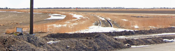
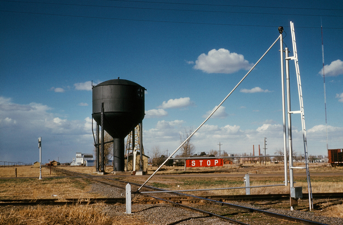
The Tower 175 diamond was sitting in the weeds a few yards from its historic
location when this photo was taken c.2001. The silver painted hinge post
adjacent to the Burlington Northern Santa Fe (BNSF) tracks marks the location of
the swing gate that protected the diamond after the interlocker was removed. The
BNSF tracks are part of a route between Amarillo (to the right) and Las Animas,
Colorado (to the left). The crossing tracks were of Rock Island heritage but
came under Texas Northwestern (TXNW) ownership in 1982 when the last seventeen
miles of the line west of the crossing was
abandoned. The diamond and a short segment of track to the west was retained, presumably
to avoid the expense of reinstalling the diamond if nearby land was acquired for
a rail-served industry. The diamond was removed in the late 1990s or early 2000s.
Left:
The Tower 175 diamond was sitting in the weeds a few yards from its historic
location when this photo was taken c.2001. The silver painted hinge post
adjacent to the Burlington Northern Santa Fe (BNSF) tracks marks the location of
the swing gate that protected the diamond after the interlocker was removed. The
BNSF tracks are part of a route between Amarillo (to the right) and Las Animas,
Colorado (to the left). The crossing tracks were of Rock Island heritage but
came under Texas Northwestern (TXNW) ownership in 1982 when the last seventeen
miles of the line west of the crossing was
abandoned. The diamond and a short segment of track to the west was retained, presumably
to avoid the expense of reinstalling the diamond if nearby land was acquired for
a rail-served industry. The diamond was removed in the late 1990s or early 2000s.
The TXNW main tracks approach from the east, come under the US 287
overpass (in the distance at left) and continue west another 500 ft. where they split into
southeast and northeast quadrant connectors to reach the BNSF tracks. The TXNW main track
that previously approached the diamond from the east has been removed west of
the connecting track junction. In the photo,
the southeast connector hosts the box cars, and they appear to extend all the way
back to the TXNW main line connection. (Jim King photo)
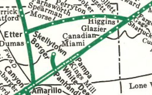
By 1910, the Chicago, Rock Island & Pacific (CRI&P)
Railroad was operating two routes through the Texas Panhandle: the Golden
State Route and the Choctaw Route. Both had been
built primarily for the purpose of making a west coast connection at
Tucumcari, New Mexico, where Southern Pacific (SP) operated a line south to
El
Paso that continued onto their Sunset Route to California. To reach
Tucumcari, the
Golden State Route went from Liberal, Kansas diagonally across the Oklahoma
Panhandle and the northwest corner of the Texas Panhandle, passing through
Stratford and Dalhart,
and entering New Mexico 41 miles southwest of
Dalhart. The Choctaw Route crossed the Texas Panhandle on a due
west heading through Amarillo, providing Oklahoma City
and points east with access to the SP connection at Tucumcari. To comply with
Texas' railroad ownership laws, these lines were officially owned by the
Chicago, Rock Island & Gulf (CRI&G), Rock Island's Texas-based subsidiary.
Rock Island shared the Texas Panhandle
with two other railroads. The Fort Worth and Denver City (FW&DC) had been the
first to lay tracks into this region, building mostly through the western
Panhandle in 1888 to reach the New Mexico border at the
new town of Texline. There, it connected to Colorado & Southern tracks to form a
continuous route between Fort Worth and Denver. The other Panhandle railroad was the
Atchison, Topeka & Santa Fe (AT&SF) Railway. By 1902, it was operating a route
from Wichita, Kansas southwest to Clovis, New Mexico via Shattuck, Oklahoma, and
the Texas towns of Canadian,
Pampa, Amarillo, Canyon
and Farwell. Like Rock Island, Santa Fe complied with state law by accomplishing this work
under Texas-based subsidiaries. Its operating subsidiary in the Texas Panhandle
had been known as the Southern Kansas Railway, but it was renamed the Panhandle
& Santa Fe (P&SF) in 1914.
By 1910, Santa Fe had begun a
significant network expansion south of Amarillo, but north of Amarillo, the main line
comprised Santa Fe's only tracks until 1917 when a branch
from Shattuck, Oklahoma was built into the far northeastern corner of the Panhandle.
In Texas, this branch helped to establish several new towns -- Follett, Darrouzett, Booker
-- and Perryton, the new county seat of Ochiltree
County. The branch terminated 26 miles southwest of Perryton at Spearman,
another town platted in 1917 anticipating the arrival of Santa Fe's tracks (they
finally reached Spearman, the end of the line, in 1919.) Elsewhere, short Santa
Fe branches off the main line to Borger (1926) and Skellytown (1927) were built
close to Amarillo. But as of 1927, a vast area of the
north central Panhandle remained void of railroads. Within the large
triangle formed by Amarillo, Stratford and Spearman, oil and gas development
helped provide the final incentive for
railroad construction.
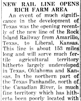 |
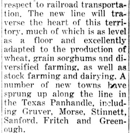
By the late 1920s, oil and gas
development north of Amarillo along with significant wheat production farther north in the Panhandle had begun
to interest Rock Island. To serve these areas, they started
construction of a
line north-northeast from Amarillo toward Liberal in 1927. Construction was slowed by the rugged terrain, particularly
crossing the Canadian River, and the tracks did not reach the Oklahoma border at Hitchland until 1929. In addition to serving
mineral industries and
agriculture, the line provided a means of routing freight between Amarillo
and the Midwest, and it potentially served as an alternate route between
Liberal and Tucumcari should Golden State Route operations become
disrupted.
Left and Right:
The Rockdale Reporter of
August 1, 1929 noted that the recent completion of Rock Island's line
between Amarillo and Liberal resulted in the founding of several new
towns in the Texas Panhandle, including Morse. Morse was significant
because it soon became the target crossing point for an extension
proposed by Santa Fe to connect Amarillo with their existing branch line
at Spearman, 18 miles northeast of Morse. |
 |
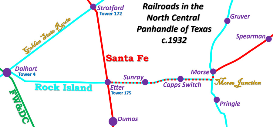
By the fall of 1929, additional railroad development in
the northern Panhandle had become a high priority. Rock Island proposed building a branch line
across the
northern Panhandle between Dalhart, on the Golden State Route, and Morse,
on the newly completed Amarillo - Liberal line, sixty miles apart. This branch
would pass through the oil and gas fields in northern Moore County, twelve miles
north of Dumas, the county seat. The Interstate Commerce Commission (ICC)
approved the line, but before Rock Island could start building it, Santa Fe requested ICC approval
of an extensive construction proposal for the northern Panhandle, duplicating to
some extent Rock Island's plan. Santa Fe began with the uncontroversial idea of
connecting its southern main line at Amarillo with its original main line at Las
Animas, Colorado, a north / south route that would go through Dumas, Stratford
and Boise City, Oklahoma. Santa Fe also sought permission to build to Dumas from their
existing branch at Spearman, an extension that would cross Rock Island's
Amarillo - Liberal line at Morse and pass through the heart of the Moore County
oil and gas fields. Rock Island
vigorously opposed this route since it would largely parallel the eastern half
of their ICC-approved line between Dalhart and Morse.
Dalhart and Morse are at the same latitude,
but Rock Island had not proposed to build a due east / west line between them. Instead, the
route went southeast from Dalhart on the abandoned Enid, Ochiltree &
Western (EO&W) right-of-way, a railroad that had been graded from Dalhart to Dumas
but had never become operational. After 5.9 miles on the EO&W, the tracks
turned due east and passed through
farming areas for 33 miles to reach an Apache Refining Co. facility at Altman.
When the Sunray Oil Co. took over the Apache refinery in 1931, the town
name was changed to Sunray (and remains so today.) In 1933, Shamrock Oil and Gas
Co. built its first refinery in Sunray, and soon thereafter, opened its first
gas station there. East of Sunray, the tracks remained on a due east heading
for about three miles and then turned east northeast for approximately three more
miles where they returned to a due east
heading. The reason for this slight jog to the north is undetermined, but it seems
likely to be related to serving particular farming operations. One of these was at Capps Switch, where a siding
was built and where
Skyland Grain now operates
a grain storage facility. About nine miles farther east, the tracks intersected
Rock Island's Amarillo - Liberal line two miles south of Morse, a location that
became known as Morse Junction.
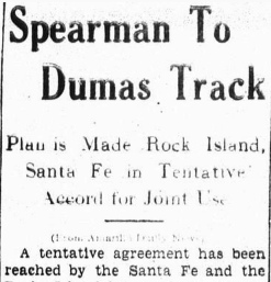
 Left:
The Lipscomb Lime Light of July 17,
1930, quoting the Amarillo Tribune,
carried this story about a tentative agreement between Rock Island and Santa Fe
to share the eastern half of Rock Island's new Dalhart - Morse line. Under the plan, Santa Fe would
build from Spearman to Morse and terminate into Rock Island's tracks between
Morse and Morse Junction. From that point, they would have overhead rights on Rock Island's tracks through Morse Junction and westward to the
crossing point of Santa Fe's new line to Las Animas, about twelve miles
north of Dumas. Connecting tracks in the two eastern quadrants would allow Santa Fe trains
from Spearman to access both the original main
line at Las Animas and the southern main line at Amarillo. The tentative
agreement left many details to be determined, and Santa Fe was required to
submit the final plan to the ICC for approval before initiating construction
between Spearman and Morse.
Left:
The Lipscomb Lime Light of July 17,
1930, quoting the Amarillo Tribune,
carried this story about a tentative agreement between Rock Island and Santa Fe
to share the eastern half of Rock Island's new Dalhart - Morse line. Under the plan, Santa Fe would
build from Spearman to Morse and terminate into Rock Island's tracks between
Morse and Morse Junction. From that point, they would have overhead rights on Rock Island's tracks through Morse Junction and westward to the
crossing point of Santa Fe's new line to Las Animas, about twelve miles
north of Dumas. Connecting tracks in the two eastern quadrants would allow Santa Fe trains
from Spearman to access both the original main
line at Las Animas and the southern main line at Amarillo. The tentative
agreement left many details to be determined, and Santa Fe was required to
submit the final plan to the ICC for approval before initiating construction
between Spearman and Morse.
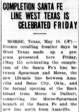
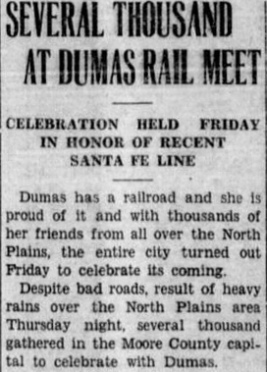
The ICC approved the final agreement in November, and the contract for
sharing the eastern half of Rock Island's Dalhart - Morse tracks was finalized
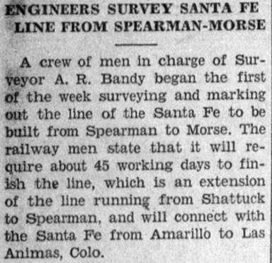
by the railroads on December 18, 1930. The survey for Santa Fe's extension from Spearman to Morse began
the following week. By the time Santa Fe's construction to Morse was finished,
their line from Amarillo to Las Animas had been completed as far north as Boise
City, Oklahoma where it intersected with other Santa Fe branch lines; the track
from Boise City to Las Animas was finished in 1937. Rock Island's Dalhart -
Morse line had also been completed, hence, new rail service was being celebrated throughout the
northern Panhandle in May, 1931. (Above Left to Right:
Shamrock Texan, December 31, 1930;
Shamrock Texan, May 13, 1931;
Yoakum Daily Herald, May 18, 1931;
Shamrock Texan, May 31, 1931)
As part of ICC's approval of the agreement, on November
13, 1930 they issued "...a certificate of public convenience and necessity to the Santa Fe
railway authorizing the construction of a line of railway from Spearman to a
connection with the Rock Island tracks in Hutchinson County, and also giving
permission to the Santa Fe to enter into a trackage rights agreement with the
Rock Island from the connecting point into Amarillo." (Lipscomb
Lime Light, November 20, 1930, quoting the
Spearman Reporter) [The "connection with the Rock Island tracks in
Hutchinson County" was the location between Morse (Hansford County) and
Morse Junction (Hutchinson County) where Santa Fe's line would terminate, about
3,000 ft. south of the county line.] West of Morse Junction, Santa Fe only
needed trackage rights to the crossing of the Las Animas line, so the language specifying "into Amarillo"
is a bit confusing. The crossing point became known as Etter, named for a Santa
Fe executive, soon to be the site of a Santa Fe water stop and depot. As the
Etter crossing was an important part of the railroads' track sharing agreement,
it seems likely that they also addressed installation of an interlocker.
Regardless of which railroad was the first to actually lay tracks at Etter,
Santa Fe was considered the "second railroad" at the crossing since Rock
Island's permission from the ICC for the Dalhart - Morse line predated Santa
Fe's authorization to build from Amarillo to Las Animas. Under Railroad Commission of
Texas (RCT) regulations, the capital outlay for interlockers at post-1901
crossings belonged
to the "second railroad", hence Santa Fe designed, funded and installed the
signals and interlocker at Etter, and they did so with the intent that the
interlocker be in place by the time both tracks were operational. At the end
of 1931, RCT published a list of
interlocker installations that had occurred during that calendar year. It showed
that a 4-function automatic
interlocking at Etter, identified as Tower 175,
had been commissioned on May 19, 1931, consistent with the celebration dates in
the news articles noted above. The January, 1932 issue of
Railway Signaling reported that the Etter interlocker
was built by Union Switch & Signal Co. and had "8 signals".
 Right:
This 1983 AT&SF System Map shows the Etter - Morse rights (at this point, on
TXNW tracks) treated like any other line in Santa Fe's network, but with no
stops between Etter and Morse (e.g. Sunray, Capps Switch). TXNW inherited Rock
Island's industrial branch running south from Sunray that eventually connected
to a Santa Fe spur (not shown on the map) coming east off the main line north of Dumas
about half way to Etter.
Right:
This 1983 AT&SF System Map shows the Etter - Morse rights (at this point, on
TXNW tracks) treated like any other line in Santa Fe's network, but with no
stops between Etter and Morse (e.g. Sunray, Capps Switch). TXNW inherited Rock
Island's industrial branch running south from Sunray that eventually connected
to a Santa Fe spur (not shown on the map) coming east off the main line north of Dumas
about half way to Etter.
Left:
As of February, 2022, the spur off the BNSF main line has been severed where the
tracks crossed US 287, five miles north of Dumas. Whether the evident road
construction was a factor in the track removal is undetermined. (Google Street
View)
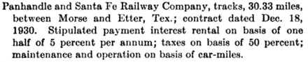 Left: This paragraph from a 1938
ICC Valuation Report discusses Rock Island
property that is "Solely owned, but jointly used with..." the P&SF, providing an
overview of the financial agreement between the two railroads.
Left: This paragraph from a 1938
ICC Valuation Report discusses Rock Island
property that is "Solely owned, but jointly used with..." the P&SF, providing an
overview of the financial agreement between the two railroads.
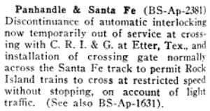 Left:
The February, 1941 issue of Railway Signaling and
Communications reported that the P&SF had filed for permission from the
ICC to make permanent the discontinuance of the automatic interlocking with the
CRI&G at Etter "now temporarily out of service", to be replaced by a
crossing gate "normally across the Santa Fe track to permit Rock Island trains
to cross at restricted speed without stopping, on account of light traffic." The
interlocker was out of service because, as noted the previous year in Volume 21
of The Signalman's Journal, the P&SF
had filed an application with the ICC requesting permission for a "...temporary discontinuance of
automatic interlocking at crossing with C. R. I. & G. Ry at Etter, Tex. on the
Plains Division..." This initial request had been granted, and by early 1941,
Santa Fe was prepared to make it permanent with the installation of a crossing
gate normally lined against their tracks. Santa Fe had insufficient
traffic across the Tower 175 diamond to justify the continued expense of
maintaining an automatic interlocker, even though such expenses were shared with
Rock Island.
Left:
The February, 1941 issue of Railway Signaling and
Communications reported that the P&SF had filed for permission from the
ICC to make permanent the discontinuance of the automatic interlocking with the
CRI&G at Etter "now temporarily out of service", to be replaced by a
crossing gate "normally across the Santa Fe track to permit Rock Island trains
to cross at restricted speed without stopping, on account of light traffic." The
interlocker was out of service because, as noted the previous year in Volume 21
of The Signalman's Journal, the P&SF
had filed an application with the ICC requesting permission for a "...temporary discontinuance of
automatic interlocking at crossing with C. R. I. & G. Ry at Etter, Tex. on the
Plains Division..." This initial request had been granted, and by early 1941,
Santa Fe was prepared to make it permanent with the installation of a crossing
gate normally lined against their tracks. Santa Fe had insufficient
traffic across the Tower 175 diamond to justify the continued expense of
maintaining an automatic interlocker, even though such expenses were shared with
Rock Island.
Below: The
Tower 175 gate was installed and was normally positioned across the P&SF tracks as shown in this photo.
Looking northeast, the P&SF depot is visible (in the distance at left) along
with the P&SF water tower. The Rock Island tracks cross horizontally in the foreground.
The black wiring that snakes up the gate pole connects to the indicator at the
top of the gate to illuminate the gate position for night operation. It was
controlled by the locked metal box near the ground. (Kenneth Moore photo,
date undetermined)
As Santa Fe had funded the
interlocker installation, they also took the lead on requesting permission to
remove it when traffic could no longer justify the maintenance expense.
Since the swing gate was to be normally lined against Santa Fe, it is unlikely that
Rock Island objected; their trains could still cross "at restricted speed
without stopping" and they would no longer have any shared expense for
maintaining the interlocker and signals. The fact that the gate was to be lined against Santa Fe suggests that its north / south trains were
mostly stopping anyway, perhaps for passengers or to handle a cut of freight cars. Thus, the added delay of stopping to
swing the gate was not significant overall, and Santa Fe trains taking either of
the Tower 175 connecting tracks would not have crossed the diamond anyway.
A small settlement
grew up around Etter and in 1940, the census reported 150 people
there. In 1942, the U.S. Government built the Cactus Ordnance
Works immediately north of Etter to manufacture ammonium nitrate for use in explosives
for World War II munitions. The town of Cactus was established, and a few
thousand people worked at the plant during peak years. The railroads benefited
from the freight and passenger traffic generated by the plant and from the families
housed on site. During the war, the plant was modified and partially shut down
as no longer needed, but then it was reactivated to produce components for
fertilizer being shipped to Europe to help restart agriculture in the aftermath
of the war. At various times over many years, the plant produced a diverse array
of commodities including ammonia, nitric acid and additives for aviation fuel.
The plant was closed in the 1980s, but the town now hosts a large meatpacking
plant. With a population over 3,000 residents, Cactus is quite a bit more than
the "wide place in the road" it once
was.
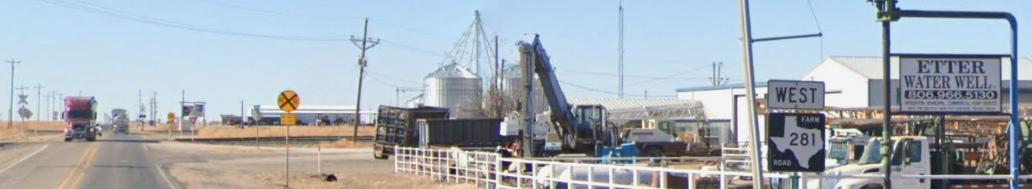 Left:
Overtaken by Cactus, the Etter name is kept alive by at least one business.
The red truck is about to cross the northeast quadrant connecting tracks. Farther
west, the
crossing signals along the highway in the distance mark BNSF's line. (Google
Street View, Jan. 2022)
Left:
Overtaken by Cactus, the Etter name is kept alive by at least one business.
The red truck is about to cross the northeast quadrant connecting tracks. Farther
west, the
crossing signals along the highway in the distance mark BNSF's line. (Google
Street View, Jan. 2022)
In 1960, Rock Island abandoned the first dozen miles of
the Morse branch out of Dalhart, stopping at Wilco, a farming operation about 17
miles west of Etter. This was the first impact
in the Texas Panhandle of Rock Island's attempt to save money by pruning its route
network. By 1964, it was
clear that Rock Island could only survive long term by seeking a merger partner.
The much larger Union Pacific (UP) Railroad agreed to be that merger partner, but the
potential deal was
complicated. Rock Island's financial picture worsened as ICC regulators held
hearings for ten years to take testimony from other railroads opposed to the
merger and to consider UP and Rock Island
counterarguments. With the merger pending, Rock Island continued pruning routes
by abandoning the south end of the Amarillo - Liberal line in 1972, retaining
the tracks north of Stinnett. The merger was approved in 1974, but the
enormity of the plan indicated how radically it would have altered western
railroading. Various terms and conditions specified by the ICC's
administrative law judge were considered onerous by UP, and they chose not to proceed with
the merger. Rock Island went into bankruptcy in 1975; attempts were made, but no
viable recovery plan was ultimately forthcoming. The assets
were liquidated, sold mostly to other railroads; the Golden State Route
was sold to SP in 1979.
On April 8, 1980, the ICC amended a Directed Service
Order they had issued in the wake of Rock Island's suspension of operations wherein individual
railroads had been authorized to serve shippers on an interim basis on specified
Rock Island routes. The amendment authorized Santa Fe to begin serving shippers
on the Etter - Morse line, including the industrial branch line out of Sunray.
(The tracks west of Etter to Wilco were not mentioned, suggesting that the Wilco
shipper may not have been active.)
Santa Fe was also authorized to serve shippers on Rock Island's line between Morse
and Liberal. The tracks from Morse south to Stinnett were not mentioned; again,
there may not have been any active shippers on that track segment. Finally, in 1982, a new railroad, the Texas Northwestern (TXNW), was
founded to acquire Rock Island's branch between Wilco and Morse, plus its
industrial tracks south of Sunray and the remainder of the Stinnett - Liberal
line north to Hardesty, Oklahoma. At this point, Santa Fe's interim service
authorization expired, but they still had their original trackage rights between
Morse and Etter.
 |
Left:
This 1982 Santa Fe track chart is oriented with north to
the left, showing tracks adjacent to the Tower 175 crossing.
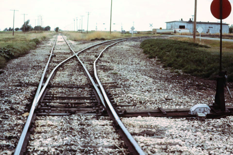
Right: In 1991, Charles Napp took this photo
facing west toward the Tower 175 crossing. The switch for the single-track northeast connector
is in the foreground. In the distance, the swing gate existed but is not
readily visible. Presumably, its normal position had been changed to be
against the TXNW tracks; to the west, the former Rock Island line to Dalhart was
abandoned although the diamond and gate remained intact. |
 |
In 1987, TXNW abandoned the tracks from Morse north to
Hardesty, and from Pringle south to Stinnett, leaving the tracks between Morse
and Pringle as the only remnant of the Amarillo - Liberal line in Texas. In
1990, Santa Fe relinquished its trackage rights between Morse and Etter, and
sold its branch from Shattuck to Morse to the Southwestern Railroad Co. (SWRR) [not to be confused
with the former Southwestern Railway Co at Henrietta.]
SWRR immediately abandoned the tracks between Spearman and Morse.
In 2004, TXNW abandoned the tracks from Capps Switch to Morse Junction, and from
Pringle to Morse, eliminating the last remaining tracks into Morse. In 2007, SWRR
abandoned its tracks from Spearman to Shattuck, Oklahoma, a distance of 85
miles.
Although pipelines now carry most of the oil, gas and refined products in the
vicinity of Etter and Sunray, petrochemical production continues to be a major
contributor to local commerce in northern Moore County. BNSF and TXNW cooperate
to serve the Valero McKee Refinery five miles southwest of Sunray, along with
numerous other industrial and meatpacking facilities in the area.
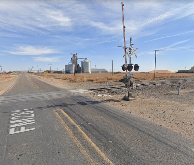
Above Left: Compare this
November, 2021 view of the site of the Tower 175 diamond with the photo at the
top of the page. (Google Street View)
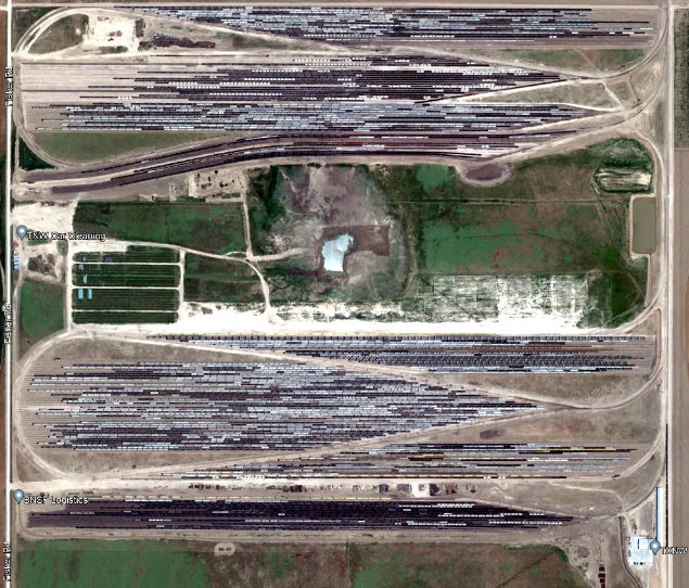
Above Right: TXNW operates a
huge facility between Etter and Sunray, reportedly the largest private railcar
storage yard in the US, plus cleaning and repair services. (Google
Earth, 2019)
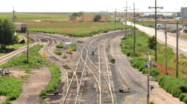
Below Left: This August, 2022 view from the US 287
overpass looks west toward the former Tower 175 crossing. Compare this with the
view from 1991 above. The track arrangement
is indicative of the significant movement of cars on both quadrant connecting
tracks, reflecting the growth of industrial facilities in the Cactus / Etter /
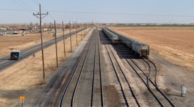
Sunray area. (Google Street View) Below Right:
This August, 2022 image looking east from the US 287 overpass toward Sunray provides another
view of the significant local rail
infrastructure. (Google Street View)