Texas Railroad History - Tower 4 - Dalhart
A Crossing of the Chicago, Rock Island
and Gulf Railway and the Fort Worth and Denver City Railway

Above: This late afternoon
photo of Tower 4 in Dalhart was taken by John W Barriger III from the rear of
his business car as he traveled southwest on the Chicago, Rock Island & Pacific
Railroad. The two-story Rock Island depot is visible straight ahead to the left
of the tracks, and there is a Rock Island herald on the building at far
right. The Fort Worth & Denver City Railway crosses behind the tower, left toward
Denver and right toward Ft. Worth. The location of the tower indicates that the
photo was taken no earlier than 1939. The camera is facing
northeast and the tower is due west of the diamond, casting a lengthy shadow
from the western sun. The relocation of the tower from its original site north of the diamond
was motivated by a 1939 Texas Highway Department grade separation project that
moved Denrock Ave. and US-87 (Pine St.) into two tunnels beneath the crossing.
(John W Barriger III National Railroad
Library)
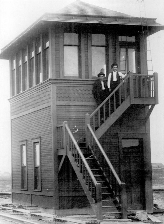
Below Left: This
uncredited photo of Tower 4 appears in the book
Dalhart
(Robin Scott, (c) Arcadia Publishing 2011, hat tip Jimmy Barlow) with a caption
that gives the date of the photo as 1901. Other than the paint color, the tower
looks
the same as the one in the above photo, but there is a key difference; the tower above is elevated. The framing directly beneath the two windows on the
lower story looks identical, but the Barriger photo shows the framing resting on
an additional layer of carpentry. If Barriger took his photo after 1939 (a
reasonable proposition),
the idea that the tower relocation project also raised the tower's elevation is plausible although the
purpose is unknown. The two
windows on the lower story are on the "long side" of the tower in both photos,
and there are six upper story windows on that side in both photos. The upper story short side windows can't be compared directly because the
visible sides are opposite. If the tower was built as
soon as the crossing was established in 1901, then the tower existed for at
least a year before the interlocker was commissioned. That might be why this particular interlocker was one of the earliest to be
commissioned, i.e. planning ahead, the railroads had collaborated to build a tower;
all it needed was an approved
interlocker installation.
Below Right:
This map (Texas Historical Commission) shows most of the
XIT Ranch
lands in the northwestern Texas Panhandle. Dalhart, supported by two railroads,
became the focal point for XIT Ranch logistics.

In 1901, the Chicago, Rock Island & Pacific (CRI&P)
Railway built southwest across the Texas Panhandle from Liberal, Kansas to
Tucumcari, New Mexico, part of a lengthier line that became known as the Golden
State Route. To comply with state law requiring railroads owning tracks in
Texas to have headquarters within the state, the construction was done under a
Texas-chartered subsidiary, the Chicago, Rock Island & Mexico (CRI&M). On the western
side of the Panhandle, Rock Island track-layers were nearing the Ft. Worth &
Denver City (FW&DC) Railway, which had built through the area in 1888 as part
of a route between its two namesake cities. The FW&DC was owned by the Colorado
& Southern, which supplied the tracks to Denver from an FW&DC connection at Texline, Texas, a town on the New Mexico border
farther north. A crossing of two major railroads in
the middle of a vast grassland near the massive XIT Ranch had the potential of becoming a
successful town, so a townsite company was formed in Fort Worth for the purpose
of building one
at the CRI&M / FW&DC crossing.
At the time, the projected crossing was known as
Twist Junction. According to the Hereford
Reporter of March 23, 1901, the townsite "...company has
purchased a section of land at Twist and will change the name to Denrock...",
a hybrid of the two railroads' names. The Denrock Sun
newspaper was quickly established, but according to the
Hereford Reporter of May 10, 1901, the
Sun had announced that "...the town's
name has been changed to Delmar." Delmar lasted all of two weeks;
a story in the Hereford Reporter of May 24,
1901 provided
the new name, Dalhart, a hybrid of Dallam and Hartley,
the two counties sharing the county line boundary that passed through the town. The Rock Island track gang reached Dalhart
on June 4, 1901, and ... "There were 500 people out to watch the gang build
into town." (Bryan Morning Eagle,
June 5, 1901) The Rock Island track-layers didn't stop, continuing past Dalhart southwest toward Tucumcari. Approved by the Post Office
Department, the Dalhart name stuck, and served by two major railroads,
it
quickly outgrew other settlements in the region. In 1903, Dalhart won an
election to become the county seat of Dallam County, replacing Texline.
Rock Island's 1901 construction coincided with the passing of a new law granting
the Railroad Commission of Texas (RCT) the authority to regulate grade crossings
of two or more railroads for safety purposes. For safety purposes, interlocker
technology was in widespread use elsewhere in the country, so RCT began
requiring interlockers to be installed at both new and existing grade crossings
of two or more railroads. Railroads could ask RCT for permission to establish an
interlocked crossing, and railroads could be ordered to interlock specific
crossings based on RCT's assessment of priorities. In all
cases, the design and installation of the interlocker had to be approved and
inspected by RCT before operations began, and to some extent, the capacity of
RCT staff to review interlockers was a limiting factor on how quickly the
technology was deployed. At uncontrolled crossings, state law required all trains to stop before proceeding across the
diamond. RCT also issued a regulation requiring grade crossings to be protected by
a swing gate with a reflective "STOP" sign as a means of protection
until an interlocker could be commissioned.
 |
Tower 4 at Dalhart was one of the first railroad towers in the state,
authorized for operation by RCT with a 28-function mechanical interlocking plant on
November 28, 1902. The early date might be traceable to the existence of the
tower structure in 1901. If the date of the above photo is accurate, the tower
had already been built and presumably was prepared to accept an interlocker
installation quickly. RCT published its first list of active
interlockers statewide on December 31, 1903. The entry for Tower 4 showed
various details including that the 28 functions were spread over 25 working
levers, the interlocker was a mechanical plant built by the Union Switch &
Signal Co., and the Rock Island subsidiary sharing the crossing was officially the
Chicago, Rock Island & Gulf (CRI&G), into
which the CRI&M had been merged a few weeks earlier.
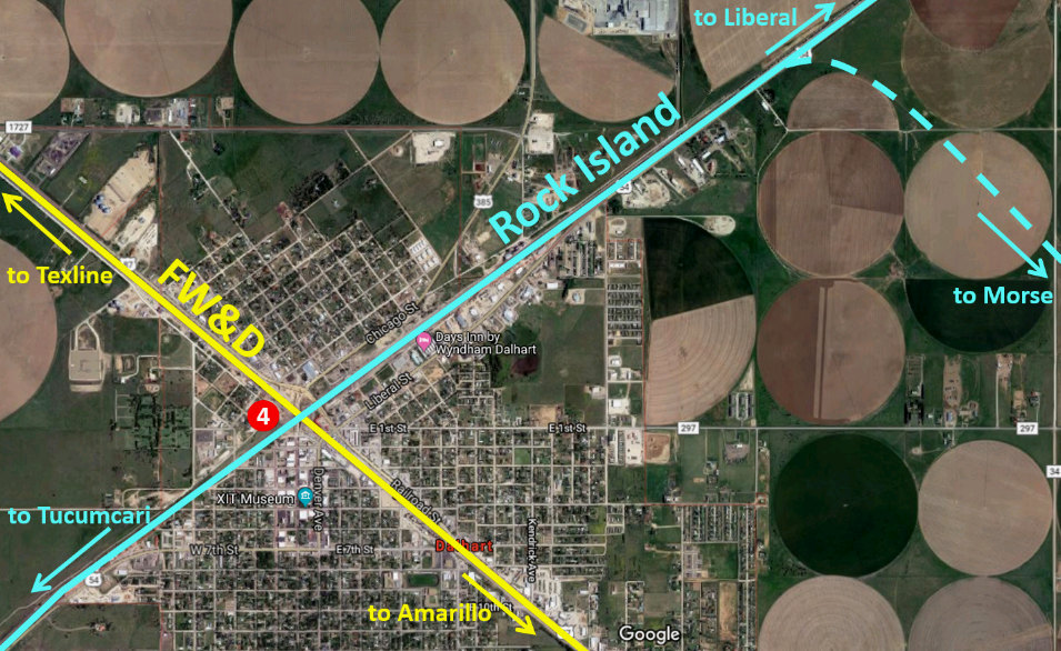
The railroads crossed in an
'X' pattern north
of the Dalhart business district. RCT archives at DeGolyer
Library, Southern Methodist University show Tower 4 originally on the north side of the 'X'. Over time, the proximity of the diamond
to Dalhart's growing downtown created a major traffic and safety problem. The
main street through downtown, Denrock Ave., crossed both lines very close to the
diamond. As waiting trains blocked this and other grade crossings frequently,
there was concern about getting emergency vehicles to the opposite side of town
at critical times. In 1939, the Texas Highway Department and the City of Dalhart
began a major project to tunnel Denrock Ave. beneath the crossing. Denrock's widening to
a divided four-lane boulevard in the tunnel
required Tower 4 to be relocated west of the diamond. A series of
temporary modifications to the interlocker was approved by RCT to facilitate continuous operation
during various phases of construction. At this time, US 87, which paralleled the
FW&DC, was tunneled beneath the Rock Island tracks 400 ft. northeast of Tower 4.
Left: Road construction at the north portal of Denrock
Ave. and along Railroad St. (US 87) was underway in 2016 when this Google Earth image of
the Tower 4 crossing was captured. The former
FW&DC runs upper left to lower right. The former Rock
Island tracks run upper right to lower left. |
In 1908, farmers in Ochiltree
County about sixty miles east of Dallam County began seeking a railroad into
their part of the eastern Panhandle. Their idea was to build a line to
Dalhart where two major railroads would offer complementary connections. A charter was granted to the Enid,
Ochiltree & Western (EO&W) Railroad on November 2, 1908, and a route was surveyed in 1909
between the town of Ochiltree and Dalhart. Between the two endpoints, the route ran far enough south into Moore
County to pass through the county seat, Dumas. Construction began at Dalhart
where materials could be shipped by rail, and the line was graded to Dumas by
the summer of 1910. A few miles of track was laid out of Dalhart to support
construction, but the work came to a halt when the EO&W was unable to pay the construction company.
The EO&W went into receivership in December, 1910 and never recovered.
In
1930, the CRI&G built a branch line between Dalhart and Morse, a town about
sixty miles east. The purpose was to connect the Rock Island Golden
State Route at Dalhart with a secondary line that Rock Island had built
between Liberal, Kansas and Amarillo in 1927. This
secondary line had been built primarily to serve agriculture production in the
central and eastern Panhandle, and in the Oklahoma Panhandle. It also served as
an alternate route between Tucumcari and Liberal using a Rock Island
line between Amarillo and Tucumcari. Should the Golden State Route become
blocked by a derailment, bridge outage, etc., the alternate route via Amarillo
was available. The new branch line between Dalhart and Morse would serve
agriculture production between the endpoints, an area in which there was no rail
service. Southeast from Dalhart, the line occupied 5.9 miles of the abandoned EO&W grade
and then turned due east to Morse. This branch
remained in service until 1960 when the first twelve miles out of Dalhart was
abandoned. After that, the remaining tracks on the west end were served from Etter,
where the branch to Morse crossed tracks built from Amarillo to
Stratford in 1931 by the Atchison, Topeka & Santa Fe
(AT&SF) Railway.
The
FW&DC tracks have remained in continuous use through the Texas Panhandle since
they were laid in 1888. In 1951, the FW&DC dropped "City" and became simply the
Fort Worth & Denver. By then, it was a property of the Burlington system, which
had acquired the Colorado & Southern in 1908. In 1970, a merger of several
railroads created Burlington Northern (BN) of which the FW&D remained a
wholly-owned subsidiary. In 1982, the FW&D was integrated into BN and ceased to
be a separate company. In 1995, BN merged with the AT&SF to create
Burlington Northern Santa Fe (BNSF). The former FW&D tracks through Dalhart
continue to be a major route for BNSF.
When
Rock Island went bankrupt in 1980, the Golden State Route was acquired
by Southern Pacific (SP) and assigned to its St. Louis Southwestern ("Cotton
Belt") subsidiary. SP's interest in the route stemmed from the fact that at Tucumcari,
SP owned a line that went south to El Paso
where it connected with their line to the west coast. From the beginning, SP and
Rock Island had cooperated on traffic between major Midwest cities and Los
Angeles via Tucumcari and El Paso. In 1996, Union Pacific (UP) acquired SP and
began operating the former Rock Island tracks through Dalhart, and continues to
do so. Tower 4 is no longer standing, and its fate is undetermined. It appears
to be visible in historic aerial imagery from 1971, but the poor image quality
makes this simply a guess.
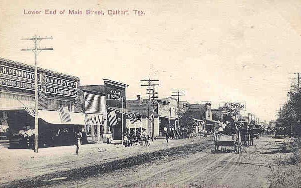
Above
Left: This photo shows
downtown Dalhart still in the
horse and buggy days.
At the edge of the
tree line on the
right side of the photo, at the far end of the street, Tower 4
is barely visible. (Texas
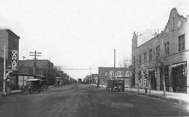
Historical Commission photo) Above Right and Below:
With early model cars and dirt streets, Tower 4 is visible in
the distance, appearing to be in the middle of Denrock Ave.! At the time, the
tower sat on the north side of the diamond and Denrock crossed the tracks
immediately beside it. (Dan Whatley
collection and Texas Historical Commission photos)
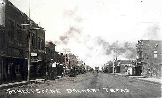

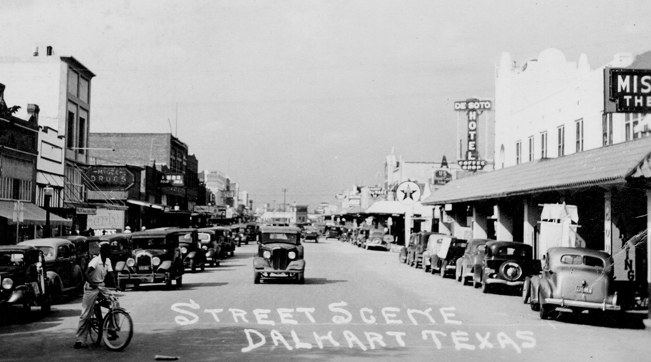
Above: Tower 4 was a prominent sight for Dalhart
residents when they went downtown. This photo is pre-1939; the tower has not yet
been relocated. (Texas A&M Corpus Christi, Special Collection)
Above Left: In this post-1939
photo, Tower 4 is on the
west side of the diamond, visible to the left of where it sat in
the older photos above. (Traces of Texas photo)
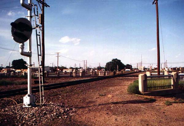
Above Right:
Facing northeast, the concrete and iron railings adjacent to the crossing
diamond serve to prevent railroad workers from falling onto the approaches to
the tunnels beneath the site of Tower 4. (Jim King photo c.1998)
Above: Tower 4 was moved west of the diamond during the 1939 tunnel
construction project. (annotated Google Earth image) Below:
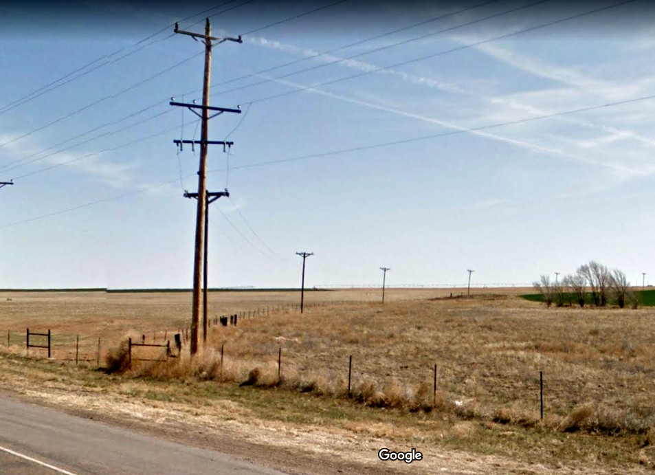
Utility poles curve to the southeast away from US 54 on the northeast side of
Dalhart showing the location where the former Rock Island right-of-way to Etter
and Morse departed the main line and crossed the highway. (Google Street View)
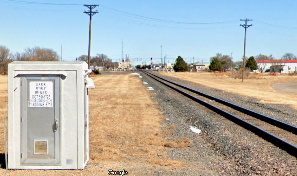
Above: This is the view from
Peters St. looking northeast along UP's tracks toward the diamond, about a
quarter mile away. Despite (or perhaps, "because of") the presence of two major
main lines, there are very few street crossings at grade in the town of
Dalhart. (Google
Street View, February, 2022)