Texas Railroad History - Tower 172 - Stratford
A Crossing of the Chicago, Rock Island and Pacific Railway and the
Panhandle & Santa Fe Railway

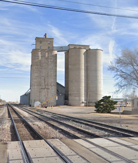
Above Left: John W.
Barriger III took this photo from the rear platform of his business car in the
late 1930's or early 1940's as his train passed through the town of Stratford
headed southwest toward Tucumcari, New Mexico. Perhaps his camera trigger finger was
prompted by the sudden appearance of the Rock Island depot to his left. Barriger's train is nearing, or perhaps already crossing, the Tower 172
diamond. Above Right: The
silos that Barriger photographed are still standing as of December, 2021.
(Google Street View)
In 1901, the Chicago, Rock Island & Pacific (CRI&P)
Railroad built southwesterly across the Texas Panhandle from Liberal, Kansas to
Tucumcari, New Mexico, passing through the tiny community of Stratford. The settlement had existed for several years on land owned by Aaron Norton; the Stratford name was reportedly chosen by
Norton's ranch foreman in honor of the Virginia hometown of
General Robert E. Lee. To comply with state law requiring railroads owning tracks in
Texas to have headquarters within the state, Rock Island's construction was done under a
Texas-chartered subsidiary, the Chicago, Rock Island & Mexico (CRI&M). The flat
grassland in the Texas and Oklahoma Panhandles had allowed Rock Island to chart
a perfectly straight track segment between Guymon, Oklahoma and a crossing of
the Fort Worth and Denver City (FW&DC) Railway where the town of
Dalhart, Texas would become established, a distance of 72 miles, one of the
longest such stretches in the country. Stratford
was near the middle, about thirty miles northeast of
Dalhart and twenty miles southwest of the Oklahoma border. The track-laying
through Stratford most likely occurred in April or May, 1901 given that the tracks
are known to have reached the FW&DC crossing on June 1st based on contemporary newspaper
reports. Rock Island's line through the northwest corner of the Texas Panhandle
was part of a lengthier route between Chicago and Los Angeles
via El Paso that became known as the Golden
State Route.
As
Rock Island was building in the northwest Panhandle, the
Atchison, Topeka & Santa Fe Railway was increasing and improving its operations
through the eastern Panhandle, a line that had been in place for a dozen
years. Their route entered Texas near the town of
Canadian and went
southwest to Amarillo, then farther southwest to
Clovis, New Mexico. Like Rock Island, Santa Fe had complied with state law by
accomplishing this work under Texas-based subsidiaries. Its operating company in
the Texas Panhandle had been known as the Southern Kansas Railway, but it was
renamed the Panhandle & Santa Fe (P&SF) in 1914.
 |
By the late 1920s, oil and gas
development north of Amarillo along with
major wheat production farther north in the Panhandle had begun to
interest both Rock Island and Santa Fe. To serve these areas, both
railroads asked the Interstate Commerce Commission (ICC) to approve
their construction plans for the Panhandle. One uncontroversial component of Santa Fe's plan was to connect
its southern main line at Amarillo with its northern main line at Las Animas,
Colorado. This would require a north / south route from Amarillo through Stratford and northwest from there to Boise City, Oklahoma. After
the ICC required the
two railroads to negotiate sharing an east / west line in the Panhandle between
Etter and Morse, it gave final approval to the railroads'
plans in
November, 1930. Santa Fe was able to begin construction immediately between Amarillo and Stratford.
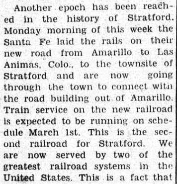
Left:
The Follett Times of December 11, 1930
quoting the Stratford Star reported
that track-laying was beginning at Stratford. Since Stratford was on the Rock
Island, Santa Fe could ship materials there by rail and build out in both
directions. This allowed more crews to work simultaneously, reducing the overall
construction time.
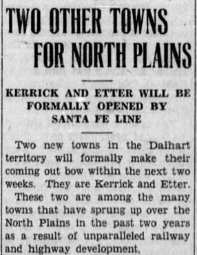
Right:
The Shamrock Texan of May 13,
1931 announced the imminent opening of two new towns, Etter and Kerrick,
on the new Santa Fe line. Etter is about 22 rail-miles south of
Stratford. Kerrick is on the Oklahoma border twenty miles southeast of
Boise City and fifteen miles northwest of
Stratford. Boise City remained the
northern terminus of the Amarillo line until 1937 when the line was
extended to Las Animas. |
 |
The two railroads crossed at Stratford in an X-pattern,
with the Rock Island running northeast / southwest and the Santa Fe running
northwest / southeast. Under Railroad Commission of Texas (RCT) rules, Santa Fe
(as the second railroad) was responsible for funding the capital outlay for an
interlocker to manage the crossing. The railroads had sufficient lead time to
design the signaling, acquire the interlocking plant, have it installed at the
crossing, and have the entire installation approved by RCT prior to the
commencement of regular operations on the Santa Fe tracks (operations on the
Rock Island continued throughout the process, interrupted only when
necessary for installation activities.) RCT records identify the interlocker as
Tower 172 and state that it was a semi-automatic interlocking plant
with eight functions commissioned on April 30, 1931. [This date happened to be
precisely one year after the first two automatic interlockers in Texas were
approved by RCT on May 1, 1930 for Lubbock and
Plainview.]
A
comprehensive listing of interlockers installed in 1931 that was published in the
January, 1932 issue of Railway Signaling
grouped Tower 172 with other automatic interlockers assigned to Rock Island,
implying that Rock Island had maintenance responsibility for the interlocker,
signals and crossing diamond (such maintenance expenses were shared with Santa
Fe.) This made sense; Rock Island had the busier line and its trains on the
Golden State Route were operating on transcontinental schedules. It was
strongly incentivized to keep the interlocker well-maintained to prevent
problems from occurring rather than simply reacting to them when they happened. Tower 172 was the only interlocker that
RCT characterized as being semi-automatic; the precise nature of how
it differed from a standard automatic interlocking is undetermined but semi
suggests that there may have been manually-operated electronic controls (most
likely placed in the Rock Island depot) that could affect the operation of the
interlocker.
A 1956 Santa Fe employee timetable indicates that the interlocker was fully
automatic by then, but the same notation does not appear in a 1950 timetable,
perhaps indicating that a change was made in that timeframe.
When Rock Island went bankrupt in the late 1970s, the Golden State Route
was sold to Southern Pacific (SP). In 1996, Union Pacific (UP) acquired SP and
inherited the former Rock Island line through Stratford, which continues to
see daily traffic. The Santa Fe line through Stratford is now operated by Santa
Fe's successor, Burlington Northern Santa Fe (BNSF).
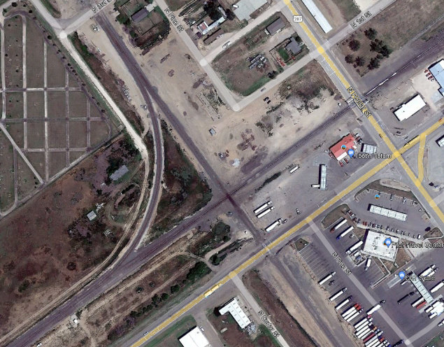
Above Left: This Google Earth satellite image from 2019
shows the X-pattern crossing at Tower 172. The connecting track in the western
quadrant was not historically present but was in place at least by 1997 as a
result of the mid-1990s mergers that created BNSF and merged SP into UP. Both
railroads have trackage rights on the other's line through Stratford.
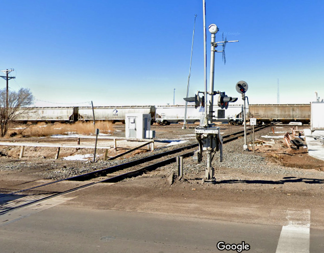
Above Right: Looking northwest
along the BNSF tracks, a UP train is crossing the Tower 172 diamond (Google
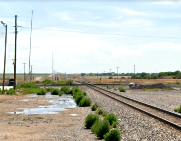
Street View, Feb. 2022) Below Left:
This view of the diamond looks southwest along the former Rock Island Golden
State Route. In the distance at right, the connecting track in the western
quadrant is barely visible. (Google Street View, Aug. 2022)
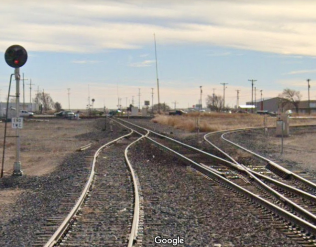
Below Right: The western
quadrant connector comes off of the BNSF line immediately south of the N. 3rd
St. grade crossing and curves to the southwest to join UP's line. (Google Street
View, Dec. 2021)
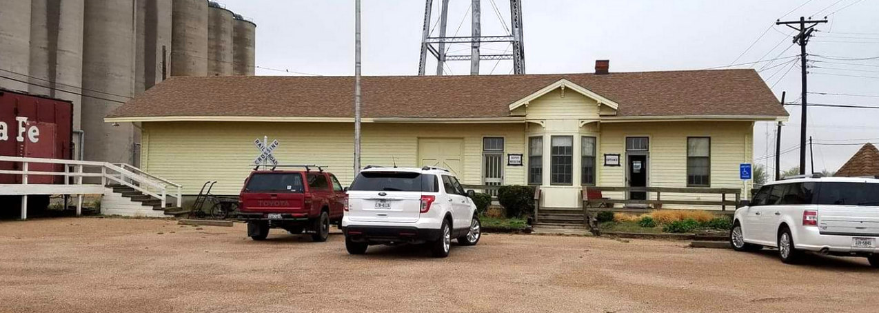
Above: Although the Rock
Island depot visible in Barriger's photo is no longer standing, Stratford's
Santa Fe depot has survived to become the Sherman County Depot Museum. It was
moved from its original trackside location and is now adjacent to the
former Rock Island tracks at 17 North Main St.