Texas Railroad History - Tower 190 - Canadian
A Panhandle & Santa Fe Railway
Interlocker for the Canadian River Bridge
 |
Left:
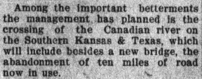
To reach a new steel bridge over the Canadian River, the Southern Kansas
Railway built new tracks (green) in the 1907-08 timeframe near the
Panhandle town of Canadian. The new bridge was three miles northwest of
the original timber bridge, which periodic floods regularly damaged,
impacting rail traffic. The
right-of-way between the two light red lines on this annotated Google
Maps image is indeterminate due to
those floods, at least as viewed from satellite imagery. Per the
El Paso Daily Times of April 19,
1905 (below), the new
bridge required
"the abandonment of ten miles of road now in use" due to the
alignment change.
Building south from Glazier, the original right-of-way (yellow) passed along the east side of Clear Creek.
Near the river, a railroad camp morphed into Hogtown (officially, the "Clear Creek"
community) while the bridge was under construction. Its completion in 1887 and the founding of the town of
Canadian led to Hogtown's gradual demise. The last school and church closed in
1913, and only a Texas Historical Commission Marker along Farm-to-Market
Road 2266 identifies its location.
Below: Santa Fe began building the new bridge in
late 1906. Track construction to the bridge site had most likely already
been completed on both sides to facilitate movement of construction
materials. The opening date for the bridge has not been
determined, but early 1908 is a good guess.
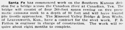
Railway Age, November 9, 1906 |
In 1914, the "Panhandle & Santa Fe (P&SF) Railway"
became the new name for the Southern Kansas Railway of Texas, a Texas-based subsidiary of the Atchison,
Topeka & Santa Fe Railway chartered in 1886 for compliance with Texas law
regarding railroad ownership. It was effectively an extension of Santa Fe's
Southern Kansas Railway subsidiary which had been laying tracks in southern Kansas and northern
"Indian Territory", now the state of Oklahoma. About 25 miles after crossing into
the northeastern Texas Panhandle, the
railroad bridged the Canadian River in the summer of 1887 where the town of Canadian
had been laid out three months earlier on the south bank. [...and as to why the Canadian River is so named,
there are various theories, but
no one really knows.]
Describing the new town, the Fort Worth Daily Gazette of September 22,
1887 reported "The Santa Fe Railroad Company have a large force of men at
work erecting a fine depot, and the largest stockyard ever built by the
company. The company have made Canadian the headquarters of this division. ...
A town but sixty days old, has only had a railroad a few days, and now contains
over 500 people, with more pouring in...every day." Among a series of
retrospective articles celebrating the 50th Anniversary of the
town of Canadian, the Canadian Record of
September 9, 1937 states that the first railroad bridge into Canadian "...was
completed either the latter part of July or the first of August, 1887. Freight
trains began to bring lumber and building material and the little tent town of
Canadian was changed into a town of wooden buildings." With the
railroad facilities completed, Canadian became a Santa Fe division headquarters
and maintenance center.
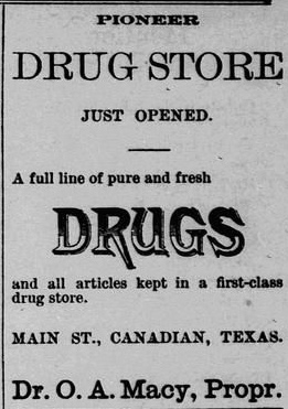
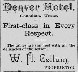
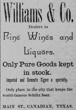
Above: The
Canadian Free Press began publishing weekly
in August, 1887, shortly after the bridge had become operational, enabling
regular delivery of newsprint, ink and printing press hardware. On September
28th, roughly sixty days after rail service had begun, these newspaper ads show how quickly
construction and commerce had
expanded in Canadian. (What? You've never heard of "world-famous Schlitz
beer"?) The main headline for the newspaper on this date was ... "Cattle Shipments are
Increasing; 8,000 Head Shipped This Week"
Beyond Canadian, the Southern Kansas continued southward into the Texas Panhandle, stopping in Carson County
where the new town of Panhandle City arose.
The Fort Worth & Denver City Railway passed nearby at Washburn, and a new
railroad, the Panhandle Railway, was chartered to fill the
15-mile gap between the two railroads. This enabled
Santa Fe to serve Amarillo using FW&DC trackage
rights through Washburn. In 1902, Santa Fe started a project, the Belen Cutoff,
to improve service to the west coast with new tracks across eastern New Mexico,
part of a faster, lower gradient route between Belen, New Mexico and Wichita,
Kansas. The Belen Cutoff would connect to existing Santa Fe tracks at
the Texas state line that ran northeast through the
Panhandle towns of Canyon, Amarillo,
Pampa and Canadian. To prepare for the traffic
surge that would follow the opening of the Belen Cutoff in 1908, Santa Fe undertook a variety of
track upgrades throughout the Panhandle, including a new bridge and alignment at
Canadian.
 |
Left: Santa Fe
needed a sturdier bridge over the Canadian River; the frequently damaged
timber bridge was twenty years old. Construction began in late 1906, and
a new alignment was built to reach the
bridge site three miles upstream from the existing bridge. The old tracks were eventually taken up, but the last mile or two into Canadian
remained intact to be used as a spur to serve the stockyards on the northeast
side of Canadian. (Fort Worth Record & Register,
March 14, 1906)
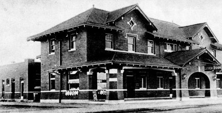
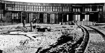
Below: Santa Fe also built
a Harvey House (1906) in Canadian
anticipating increased travelers, and a new roundhouse and machine shops
(1908) for improved maintenance. (photos from
Hemphill County by Susan Caudle)
 |
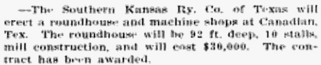
Railway & Engineering Review,
August 8, 1908
[8/8/8 !] |
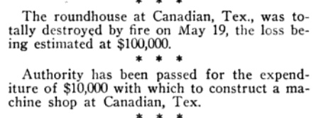
Sources
differ on the precise timing of some of this construction. The book
Hemphill County by Susan Caudle says the
new roundhouse and machine shops were built in 1907, but
Railway & Engineering Review (left)
has a different timeframe. And if the
Santa Fe
Employees Magazine of June, 1909 is correct (right),
the roundhouse was destroyed by fire on May 19th, but the machine shops
had not yet been built. |
 |

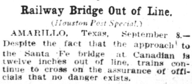
Above: Perhaps a year after the new
bridge over the Canadian River opened, it was
tested by a major flood. Despite some misalignment on the approach
to the bridge, it remained in service.
(Houston Post,
September 9, 1909) [9/9/9 !]
Left: A group of people
was photographed beside the flooded Canadian River on September 8, 1909, with Santa
Fe's steel bridge in the background. ((c) 1909, G. A. Addison, Canadian, Texas)
Below: A 1923 flood
created a new channel around the north end of the bridge, forcing Santa Fe ("This company") to extend
its length.
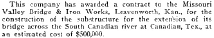
Railway Engineering & Maintenance, March,
1924
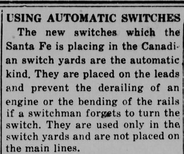
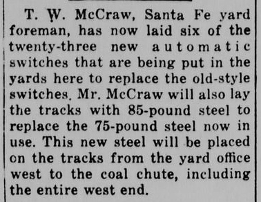
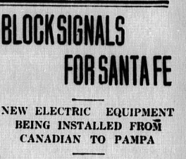
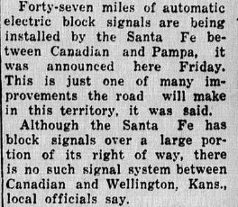
Above: Santa Fe continued periodic upgrades to the
facilities at Canadian, adding automatic switches and heavier steel rails in 1921. In 1927, a
major signaling upgrade was undertaken to install automatic block signals
between Canadian and Pampa. (Left-to-Right:
Canadian Record, January 13, 1921;
Canadian Record, January 20, 1921;
Canadian Record, April 30, 1927)
 |
By the 1930s, improving the roads in
Hemphill County had become a major issue for its residents. A three inch headline in the
Canadian Record of March 27, 1930 read "COUNTY
ROAD BONDS CARRY", announcing the election results approving a major
Hemphill County bond
issue devoted to road construction. By then, a few of the
main streets of Canadian had been paved, likely with bricks, but the county
roads were poorly constructed, mostly dirt, barely adequate for the semi-arid
climate and worthless during huge downpours that sometimes filled the river.
Among various projects, the bond money would help
the state fund improvement and conversion of select county roads into state highways,
albeit graveled, not paved. One of these state highways was to
pass through Canadian where it would use an existing paved street within the city limits.
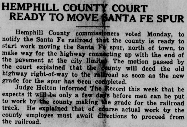
County
officials began negotiating with Santa Fe to eliminate the spur to the
stockyards so that the new highway would not
have to cross the tracks. This implies that the stockyards had already closed (date
undetermined), and
use of the spur had diminished. The
Canadian Record of February 23, 1933 titled an
article
"SANTA FE WILL MOVE SPUR FOR STATE HIGHWAY", and the story explained that "Agreement
has been reached between the commissioners court and the Panhandle & Santa Fe
Railway Company on moving the railroad spur track at the north edge of the city
in order to permit the new highway to be operated without having to cross
railroad tracks." The county agreed to pay for moving 900 feet of track
onto a new right-of-way it would build beside the new highway. The end result would be that the
new
spur track "...will parallel the road instead of crossing it."
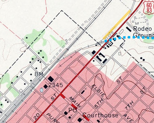
Left: This
1972 U. S. Geologic Survey topographic map has been annotated to show
where the spur crossed the highway (blue dashes), replaced by a spur
parallel to the highway (orange line.) By 1972, the spur had been
shortened from its original 900 ft. length, which terminated originally
at the angled road across the highway from the rodeo grounds. |
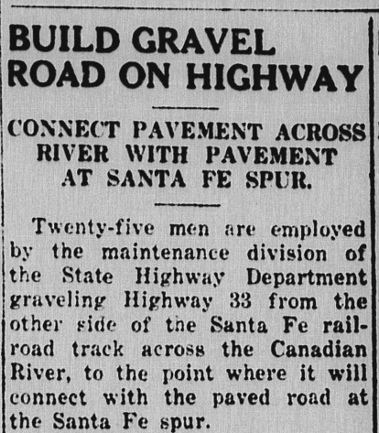 |
Left: The
Canadian Record of April 13, 1933 reported
significant work activity on the highway on both sides of the Canadian River. The
"paved road at the Santa Fe spur" was where the city limits ended; the spur had
not yet been relocated. The sub-headline mentions "Pavement Across River", but
this seems highly unlikely, especially since the story says the men were
"graveling" the highway.
Right:
It was another year later, April 12, 1934, when the
Canadian Record was able to report that the
County was finally ready to proceed with the spur relocation effort. |
 |
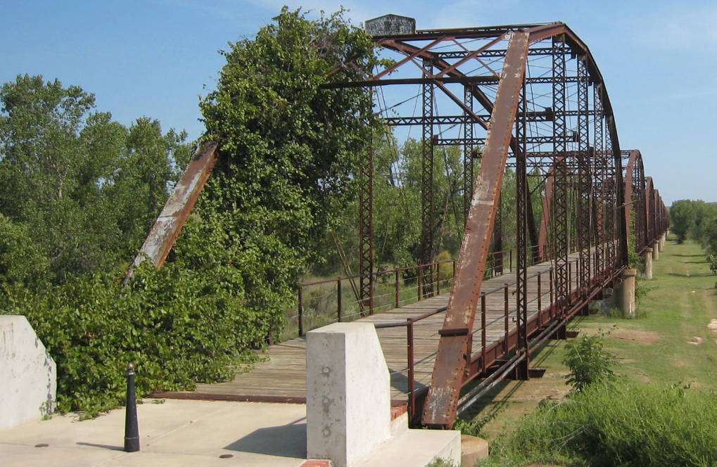
Below: The state highway
through Canadian used the "permanent" road bridge over the Canadian
River that had opened in July, 1916; two earlier bridges had washed away in floods. In 1923, another flood
cut a channel around the north end of the bridge, so five additional spans had
to be added, giving it a total length of 3,255 ft. Even in the 1930s, its 16-foot width was sometimes too narrow for passing traffic. A new highway bridge
was finally built in 1953, and the old bridge with its wooden plank surface was
allowed to rot away. In the late 1990s, it was completely rehabilitated and opened for
pedestrian traffic in 2000. (Jim King photo, August 30, 2008)
Railway Signaling & Communications
June, 1944 |
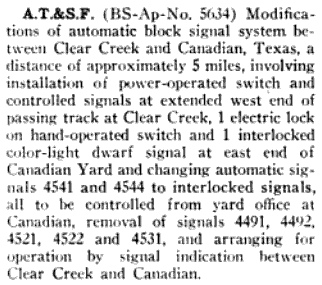
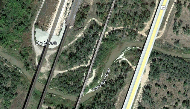
Left: In June, 1944,
Santa Fe obtained approval from the Interstate Commerce Commission (ICC)
to modify its block signaling system between the rail yard at Canadian
and the north end of the siding ("passing track") at Clear Creek (see
map at top of page.) The Clear Creek passing track was 4.15 miles long
and ended at the north end of the single-track rail bridge over the
Canadian River. Double track resumed off the south end of the bridge past
the depot and
into the Canadian yards. The entire distance was effectively five miles of double track except for the single track bridge. The
approved design change used an interlocker to manage access to the
bridge and the siding at Clear Creek, presumably under automatic
signaling with override controls housed in the yard office. The Railroad
Commission of Texas (RCT) identified the interlocker as Tower 190, but
the date that it was placed into service in the 1944-45 timeframe is undetermined.
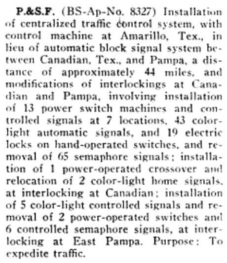
Right: Two years
later, Santa Fe was authorized by the ICC to install a Centralized
Traffic Control system at Amarillo to replace the automatic block
signal system between Canadian and Pampa. The changes resulted in
"...modifications of interlockings at Canadian and Pampa..." The
modifications to the Tower 190 interlocker involved "...installation of
1 power-operated crossover and relocation of 2 color-light home
signals..." And what was the purpose for all of this investment? "To
expedite traffic." (Railway Signaling,
August, 1946) |
 |
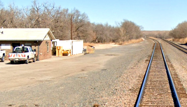
Above Left: This modest brick building became the Santa
Fe depot at Canadian and now serves as the local office for Burlington Northern
Santa Fe (BNSF), the surviving company from the 1995 merger of Santa Fe and Burlington Northern. Looking north toward the Canadian River, the double track main
line begins to diverge about 600 ft. past the building. The left track goes to
the newest bridge, a track added c.2004 to create a
double track over the river. (Google Street View, Feb. 2022)
Above Right: The four bridges
over the Canadian River north of town are (left-to-right): the newest BNSF
bridge, primarily for southbound traffic; the 1906 bridge that was extended in 1923, primarily for
northbound traffic; the 1916 wagon bridge; and U. S. Highway 60. And yes, trains do
sometimes cross both
bridges simultaneously.
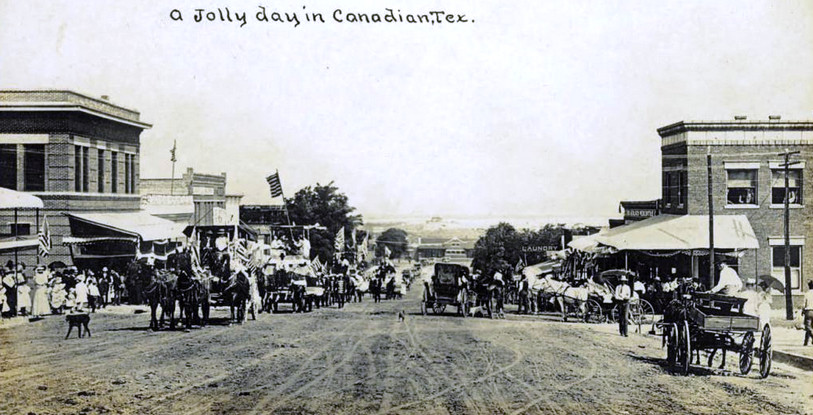
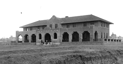
Above: This postcard photo
taken in Canadian by Henry R. Schmidt c.1910 shows the view to the northwest
along Main St. Note the two 2-story brick buildings in the foreground on the opposite
sides of the street; both are still standing in 2023. At the far end of the street, the
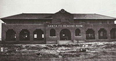
"street side" of the Santa Fe Reading Room building
is visible. The Santa Fe tracks ran behind the building. (The undated photos
below, courtesy River Valley
Pioneer Museum, were taken on the "track side.")
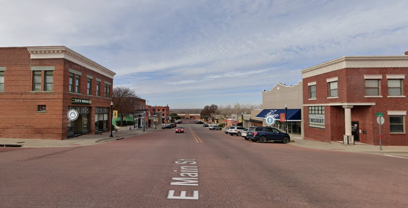
Below: This Google Street View
from December, 2021, shows the same two buildings in the foreground on opposite
sides of the street. What appears to be the Santa Fe Reading Room is visible at
the far end of Main St., but it is shifted slightly to the left compared to the
postcard photo. This is
because it's not the Santa Fe Reading Room, merely a facade designed to be a replica of the Reading
Room. It is the home of the River
Valley Pioneer Museum, built in a repurposed lumber yard structure that was erected
after the Reading Room was demolished. Unfortunately for Canadian, none of its
original railroad structures -- the Reading Room, the Harvey House, the Santa Fe
depot -- avoided demolition. The roundhouse was severely damaged in a locomotive
boiler explosion on April 12, 1951 and was not rebuilt. Santa Fe reassigned all
of its former activities to Amarillo and closed the division offices in
Canadian.
Thanks to Jeff Ford for his assistance in
researching the Santa Fe line change.