Texas Railroad History - Tower 165 - Corsicana
A Crossing of the Texas Electric Railway and the
Trinity & Brazos Valley Railway
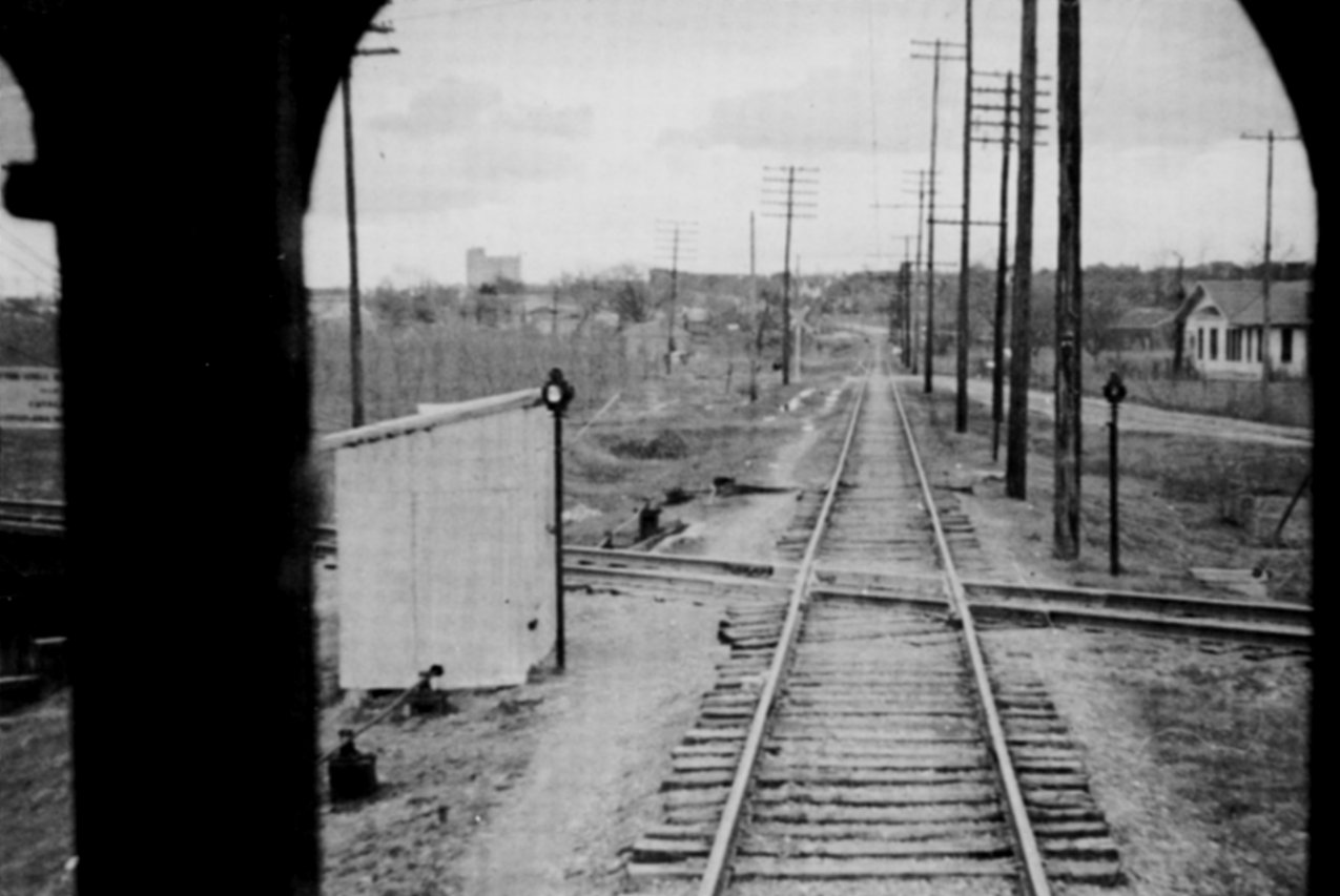
Above: Photographed through an
interurban car window by Charles Van Winkle sometime in the 1931-1941 timeframe, this is the Tower 165 crossing of the Texas Electric
Railway
and the Burlington-Rock Island railroad. The view is south-southeast along the Texas
Electric toward downtown Corsicana with the Commerce St. (also called Navarro
St.) grade crossing marked
by the white crossbuck. In the distance, the track can be seen curving to the
left where the TE reached Beaton St. and swung to a more southeasterly heading
toward downtown. This photo appears
in Texas Electric Railway by Johnnie Myers
(1982, Central Electric Railfans' Association, hat tip Jimmy Barlow.) The caption in the book reads:
"Burlington - Rock Island crossing just north of
Corsicana. Crossing was protected by derails normally set against Texas Electric
trains and manually controlled by the TE operator."
Corsicana became a major junction in the early days
of Texas railroading. By 1907, it had three railroads, a bounty of rail service
that greatly benefitted the community. Corsicana grew large enough that by 1913,
its size had enticed the Southern Traction Company to build an electric
railroad to Corsicana from Dallas. Entering the north side of Corsicana,
Southern Traction built across tracks of the Trinity & Brazos Valley (T&BV) Railway, one
of the three "steam railroads" serving Corsicana. This crossing was
approximately 425 yards northwest of a bridge where the Southern Pacific (SP)
main line simultaneously passed over the T&BV tracks and Post Oak Creek. In 1917, the Southern
Traction Company and the Texas Traction Company merged to form the Texas
Electric (TE) Railway.
In 1930, the TE began to establish controls for
its grade
crossings of steam railroads. A table of active interlockers dated December 31,
1930 published by the Railroad Commission of Texas (RCT) identifies Tower 165 as
the TE/T&BV crossing in Corsicana, and it is noted as under construction
in lieu of listing its commissioning date. Two
other crossings involving the TE -- Tower 166 (Plano) and
Tower
167 (Hillsboro) -- are also identified as under construction. In 1931, a
fourth such crossing was commissioned, Tower 174 in
Italy; it did not make the 1930 table because that list ended at
Tower 170. (As
1930 was the last comprehensive interlocker table published by RCT, the actual
commissioning dates for these interlockers have not been determined.) The
specific impetus for multiple TE interlocker installations c.1931 is unknown,
but it is very likely related to a push by RCT in the latter half of the 1920s
to upgrade minor crossings (where a lightly used line crossed a heavily used
line) throughout Texas using cabin interlockers or remote controlled electric
interlockers. This effort had begun in late 1925 and accelerated throughout the
remainder of the 1920s. Seventeen such interlockers were commissioned in 1929
alone. Activity continued into 1930 and then tapered off by 1932.
In 1930 while Tower 165 was in the planning
and construction stage, the T&BV was reconstituted as the Burlington-Rock Island
(B-RI) Railroad after a lengthy receivership. The bankruptcy plan put the B-RI
on a solid financial foundation, owned equally (and operated jointly) by two
large railroads, the Burlington and the Rock Island. The B-RI operated
successfully for many years through Corsicana, and its main line remains in
operation under current ownership of Burlington Northern Santa Fe (BNSF),
successor to the B-RI's interests. The TE, however, was not so fortunate.
Operations to Corsicana ceased in 1941, never to return.
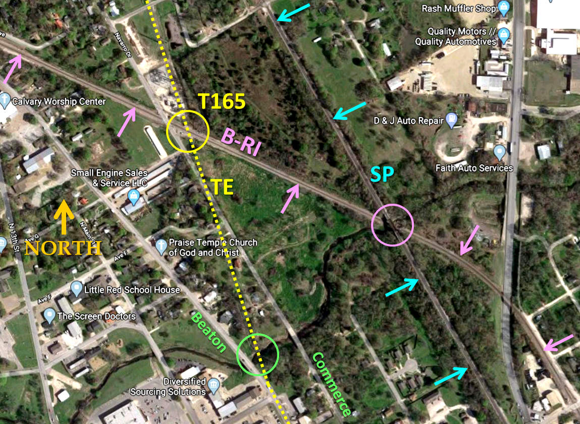
Above: This annotated Google Maps satellite image shows the path of
the TE (yellow dotted line) and the two nearby railroads. The SP tracks (blue
arrows) came first, and its construction would have included a bridge over Post
Oak Creek (pink circle). When the T&BV (pink arrows) came along in 1907, it
decided to lay its tracks beneath SP's Post Oak Creek bridge as a means for achieving a
grade-separated crossover. Whether this necessitated SP building a new, higher
bridge is unknown. The TE's crossing of the T&BV (yellow circle) was less
than 1,300 feet northwest of the T&BV bridge over Post Oak Creek. This crossing
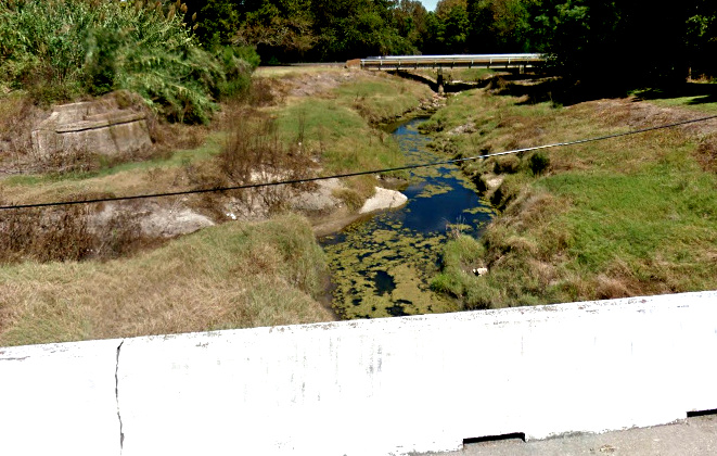
became Tower 165 in 1931 by which time the T&BV had become the B-RI. The green circle
identifies the location of the TE's Post Oak Creek bridge, for which an abutment (below left, left side of
Google Street View image )
remains in place, as seen from Beaton St., with the Commerce St. bridge
over Post Oak Creek visible in the distance. Below Right: The TE's oblique angle
crossing of Commerce St. is indicated by the path of the utility poles. This is
the street crossing marked by the white crossbuck in the image at top of page.
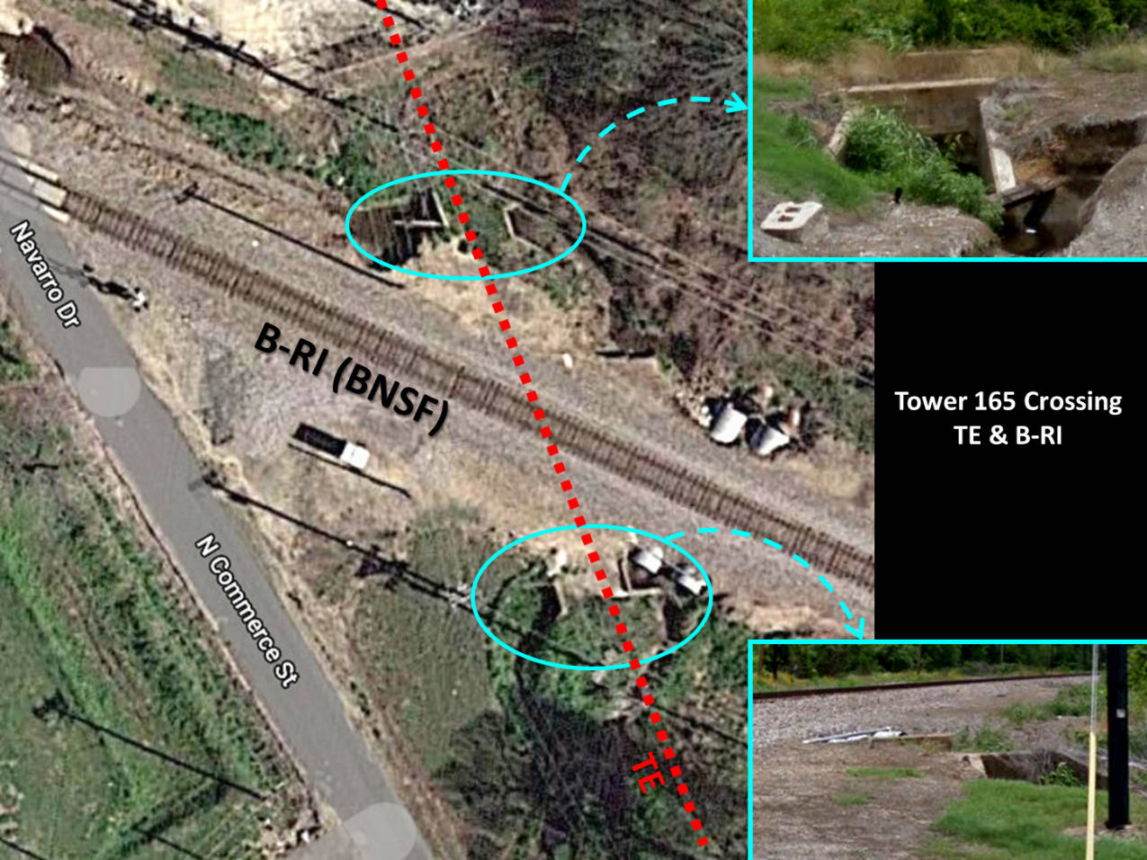
Above:
This annotated Google Maps satellite image (with Street View insets) shows two
concrete culverts that remain in place that carried the TE's tracks over a
drainage at the Tower 165 crossing. Below:
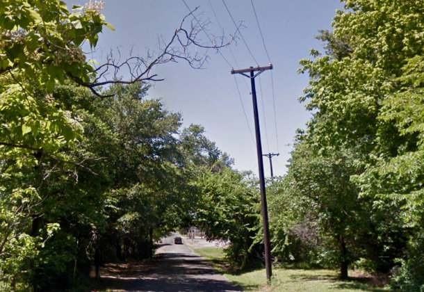
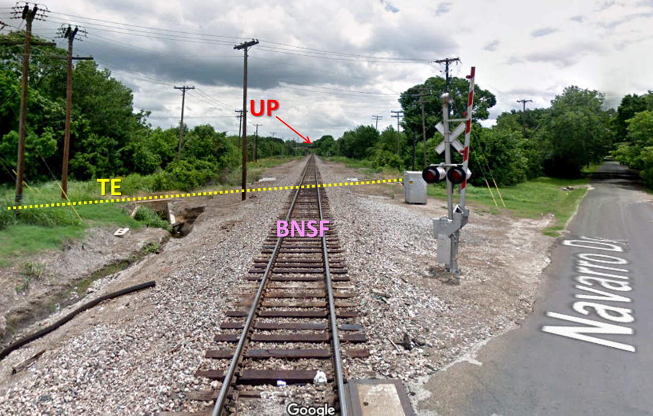
Looking southeast down the BNSF tracks in 2013, the abandoned TE culverts mark
the path of the TE. Utility poles also mark the TE right-of-way. UP's bridge
over Post Oak Creek is visible in the distance where the BNSF tracks pass beneath. Google Maps identifies the cross street as
Navarro, but immediately south of the tracks the name changes to Commerce.
(Google Street View)

Last Revised: 01/29/2021 - Contact the Texas
Interlocking Towers Website