Texas Railroad History - Tower 127 - Tenaha
Crossing of the Gulf, Colorado & Santa Fe Railway and the
Houston East & West Texas Railroad
 |
Tenaha, Timpson, Bobo and
Blair
On that H and a TC line, Old east Texas a-sure looks fine
Drop me off just a-anywhere, Tenaha, Timpson, Bobo, and Blair
Hear
those drivers a-pound the rails, Takin’ me back to Texas trails,
Bought my
ticket, I paid my fare, Tenaha, Timpson, Bobo, and Blair
Woo oo oo,
waitin' for the whistle, Woo oo oo, longin' for the whistle
It means the
station's not so far from where we are
Let’er highball, engineer,
Pull that throttle, track is clear,
There’s a gal a-waitin’ there, Tenaha,
Timpson, Bobo, and Blair.
by Woodward Maurice "Tex" Ritter
recorded
December 30, 1947, Capitol Records, Hollywood, California
Left:
The cabin for the Tower 127 interlocker at Tenaha used a common,
concrete construction design, intended to be occupied briefly and infrequently. Similar
brick and concrete huts built by Santa Fe to house cabin interlockers were located at
Wharton and Tuscola (photo by Bill King, 1999.) |
It was a marching and gambling chant coined by east
Texas soldiers that Tex Ritter adapted into a song title in the late 1940s, and it probably
didn't take him long to fill out the lyrics. Ritter understood the phrase; he was
from Panola County, north of Shelby County where Tenaha, Timpson, Bobo and
Blair were located. He took liberties with the first verse, opting to sing "H and a
TC", as in "H&TC", Houston & Texas Central Railroad,
which fit the beat of his simple melody much better than "H E and a W T" as in "HE&WT", Houston East
& West Texas Railroad, the railroad that actually passed through the four
"communities" (Tenaha and Timpson were and still are legitimate "towns"; Bobo
and Blair, not so much.) Ritter's railroad choice wasn't too far off -- the H&TC and HE&WT were
both owned by Southern Pacific (SP), and both had been merged into SP's operating
company for Texas and Louisiana lines, the Texas & New Orleans (T&NO) Railroad,
in 1934; by then, Ritter was nearly thirty years old. The theory that the chant originated with railroad conductors strolling
through passenger cars and calling out the names is suspect as the correct order
would have been "Tenaha, Bobo, Timpson and Blair" for a southbound train from
Shreveport heading for Houston.
Ritter's deep east Texas accent gives
"Ten-ee-haw" a sound perhaps similar to its original pronunciation which derives from "Tenehaw", the name
under which the future Shelby County was first organized by the Mexican
government in 1824. The Republic of Texas renamed it Shelby County in 1836 for Isaac Shelby, a war hero and governor of Kentucky. The town of
Tenaha was founded by the HE&WT as a
water stop and a shipping point for east
Texas agriculture. The tracks through Tenaha were part of the final HE&WT
segment of narrow gauge construction from
Houston to Shreveport in 1885. Nearly a decade later, the entire 191-mile railroad
was converted to standard gauge on a single day, July
29, 1894, making it a more attractive target for SP, which acquired the HE&WT in 1899.
 |
In 1894, lumber baron John H. Kirby
founded the Gulf, Beaumont & Kansas City (GB&KC) Railway to
provide port access for his east Texas lumber mills and to reach
additional forest areas where he held timber leases. By 1899, 63 miles
of
track had been laid between Beaumont and Roganville. Kirby sold out to
the vast Atchison, Topeka & Santa Fe Railway which leased it to the
Gulf, Colorado & Santa Fe (GC&SF) Railway, its main operating subsidiary
in Texas. In 1898, Kirby had also invested in the Gulf, Beaumont & Great
Northern (GB&GN) Railroad which laid tracks north out of Roganville.
It reached Center in 1904 and was then leased to the GC&SF. Other
investors chartered the Texas & Gulf (T&G) Railway to purchase three
smaller east Texas railroads south of Longview and construct additional
tracks, planning to complete a 150-mile line from Longview to the Gulf of Mexico.
Ambitious but underfunded, the T&G investors sold out to Santa Fe in
1906; the T&G was promptly leased to the
GC&SF. Under the T&G charter, the GC&SF built the final 21 miles between Center
and Gary, crossing the HE&WT at Tenaha to complete a Santa Fe line between Longview and Beaumont.
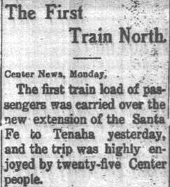
Top
Left: Quoting the Center News, the Timpson Times
of May 7, 1909 announced that the first Santa Fe excursion train from
Center to Tenaha ran on Sunday, May 2, 1909.
Bottom Left:
Santa Fe's crew built across the HE&WT
at Tenaha as track-laying began toward Gary. The Post Office had changed
the name from Zuber to Gary in 1899, but old names die hard.
(Panola
Watchman, May 12, 1909, quoting the
Tenaha Messenger)
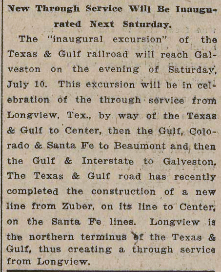
Right:
With the new tracks into Gary finished, the
Galveston Tribune of July 5, 1909
announced service between Longview and
Galveston via Beaumont. South of Beaumont, the Gulf & Inter-State
Railway, a Santa Fe property, would carry the train to Port Bolivar from
which a rail ferry to Galveston operated. Despite the T&G claim, the
"inaugural excursion" was
a Santa Fe train. |
 |

The crossing at Tenaha that was created in May, 1909 remained uncontrolled until May 22, 1928.
On that date, Tower 127 was
authorized for operation by the Railroad Commission of Texas (RCT) as a
cabin interlocker with an
8-function mechanical plant. Cabin interlockers were typically used where
a lightly used branch line of one railroad crossed the main line of another
railroad, providing an efficient option for such crossings. The alternatives
were to incur the capital, labor and maintenance expenses of
building and staffing a manned tower at a crossing where operators would change the signals
only infrequently, or ... suffer the delays (and increased fuel consumption) of
forcing all main line trains to come to a complete stop before crossing the
diamond, as required by state law for uncontrolled crossings. Instead, the
signals controlled by a cabin interlocker would be lined to allow unrestricted
movements on the busier track, to be reversed only when a crewmember from a train on the lightly used track entered the cabin to change the
signals so his train could cross. When
the crossing was complete, the signals would be returned to their normal
position by the crewmember, who would then re-board his train to continue its
journey, leaving the interlocker controls as he had found them upon arrival.
For Tower 127, the signals were set to allow unrestricted operations on SP's
line, and Santa Fe crews would use the controls in the cabin when they needed to
cross. Santa Fe built and maintained the cabin, and had responsibility for maintenance
of the interlocking plant, signals and derails. The eight interlocker functions
were most likely a home signal in each of the four directions, and a distant
signal and derail in both directions on the SP tracks. The Santa Fe tracks did
not need distant signals and derails -- fixed signs were sufficient to warn
trains they were approaching a
crossing where they were always required to
stop. The home signal was needed for Santa Fe
trains because even though its crewmember reversed the controls, the interlocking plant would not immediately grant
the signal to proceed if the SP tracks were occupied within the span of its distant signals.
 |
Left: This late 1970's photo of the Santa Fe
depot at Tenaha was taken by John Treadgold. The station was located
east and slightly south of the diamond, across the SP tracks from the
Tower 127 cabin visible in the photo. The depot appears to have been removed in the 1984-85
timeframe based on historic aerial imagery.
The Tenaha crossing remains active
today, with the former SP tracks owned by Union Pacific (UP) and the former
Santa Fe tracks owned by Burlington Northern Santa
Fe (BNSF). |
 |
Left:
The crossing at Tenaha is an 'X-'pattern, with UP rails running
northeast / southwest and the BNSF line running northwest / southeast.
The only connecting track is in the north quadrant. (Google Earth,
March, 2022)
Right:
This 1956 aerial image shows there was formerly a connecting track in the eastern quadrant
behind the Santa Fe depot. ((c)historicaerials.com) |
 |
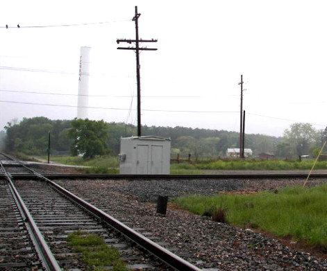
Right:
Tower 127 was the last interlocking in Texas to be guarded by
semaphores. The photo at far right faces northwest along the BNSF tracks toward Longview. The near photo faces
southwest down
UP's line toward Timpson and Nacogdoches. The original cabin sat north
of the diamond. In the satellite image above, its replacement is visible
in the west quadrant casting a shadow to the northwest. (Mark St. Aubin
photos, c.1994)
Below:
an SP train crosses the Tenaha diamond (Tom Kline, March 3, 1994)
 |
 |
 |

 Above Left: The cabinet
that replaced Tower 127's brick hut sits in the west quadrant of the crossing
as
photographed by Mark St. Aubin on November 9, 2006.
Above Right: The brick hut had been removed by the
time Mark photographed the crossing again on April 10, 2007.
Above Left: The cabinet
that replaced Tower 127's brick hut sits in the west quadrant of the crossing
as
photographed by Mark St. Aubin on November 9, 2006.
Above Right: The brick hut had been removed by the
time Mark photographed the crossing again on April 10, 2007.

Left: In an email dated November 10,
2006, Mark St. Aubin comments on this photo...
"On my way to Texarkana
yesterday I stopped by the BNSF/TIBR - UP crossing in Tenaha. The
UP has 3-color
block signals in place turned away from the main line out of service. The
BNSF's
2-color signals have been replaced by newer 2-color signals which are in
service.
The brick cabin style Tower 127 is being replaced by a metal cabin that
the UP has put
onto the northwest corner of the diamond. The ATSF Tenaha station
sign has been replaced
by a newer BNSF station sign."
Mark's view is northwest
along the BNSF tracks toward Longview. His reference to "BNSF/TIBR" reflects the
fact that at the time, the BNSF line had been leased to the Timber Rock ("TIBR")
Railroad. TIBR's lease on this BNSF route is no longer in place.
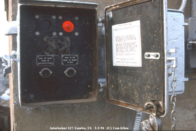

Above Left: Tower 127 was
converted to an automatic interlocker in 1982, but the interlocker retained
externally-mounted controls to facilitate the occasional situation where
overrides were necessary by train crews. A close-up of
the control box in 1994 shows two
buttons. The left button reads "PUSH TO
CLEAR SANTA FE NORTHWARD SIGNALS";
the right button reads "PUSH TO PUT SANTA FE SIGNALS TO STOP".
The operating
instructions were posted on the interior face of the control box door (Tom Kline
photo.) Above Right: The
new cabinet that replaced the brick hut has override controls for the automatic interlocker mounted on the side (Mark St. Aubin, April, 2007.)

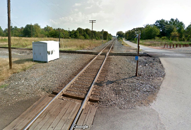
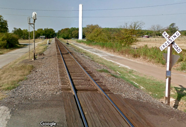
As there are two grade crossings
at right angles adjacent to the Tenaha diamond, Google Street View captured
views in all four directions in September, 2013.
Clockwise from upper left: northwest on BNSF, northeast
on UP, southeast on BNSF, southwest on UP.


Above: Cafe mural on N. Center
St., Tenaha (Google Street View, April, 2021)